The Green Line is a light rail system run by the Massachusetts Bay Transportation Authority (MBTA) in the Boston, Massachusetts, metropolitan area. It is the oldest MBTA subway line, and with tunnel sections dating from 1897, the oldest subway in North America. It runs underground through downtown Boston, and on the surface into inner suburbs via six branches on radial boulevards and grade-separated alignments. With an average daily weekday ridership of 137,700 in 2019, it is the third most heavily used light rail system in the country. The line was assigned the green color in 1967 during a systemwide rebranding because several branches pass through sections of the Emerald Necklace of Boston.

The Orange Line is a rapid transit line operated by the Massachusetts Bay Transportation Authority (MBTA) as part of the MBTA subway system. The line runs south on the surface from Oak Grove station in Malden, Massachusetts through Malden and Medford, paralleling the Haverhill Line, then crosses the Mystic River on a bridge into Somerville, then into Charlestown. It passes under the Charles River and runs through Downtown Boston in the Washington Street Tunnel. The line returns to the surface in the South End, then follows the Southwest Corridor southwest in a cut through Roxbury and Jamaica Plain to Forest Hills station.

Park Street station is an MBTA subway station in Boston, Massachusetts. It is located at the intersection of Park Street and Tremont Street at the eastern edge of Boston Common in Downtown Boston. One of the two oldest stations on the "T", Park Street is the transfer point between the Green and Red lines, as one of the quartet of "hub stations" on the MBTA subway system. Park Street is the fifth-busiest station in the MBTA network, with an average of 16,571 entries each weekday in FY2019.

North Station is a commuter rail and intercity rail terminal station in Boston, Massachusetts. It is served by four MBTA Commuter Rail lines – the Fitchburg Line, Haverhill Line, Lowell Line, and Newburyport/Rockport Line – and the Amtrak Downeaster intercity service. The concourse is located under the TD Garden arena, with the platforms extending north towards drawbridges over the Charles River. The eponymous subway station, served by the Green Line and Orange Line, is connected to the concourse with an underground passageway.
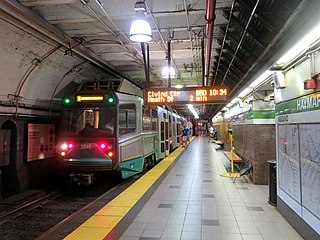
Haymarket station is an underground Massachusetts Bay Transportation Authority (MBTA) rapid transit station located at Haymarket Square in Boston, Massachusetts. It is a transfer station between the Green Line and Orange Line of the MBTA subway system, as well as a terminal for MBTA bus routes serving northern and northeastern suburbs. The two lines run parallel to each other through the station, with two side platforms for the Orange Line and a single island platform for the Green Line. The station is fully accessible.

Boylston station is a light rail station on the MBTA Green Line in downtown Boston, Massachusetts, located on the southeast corner of Boston Common at the intersection of Boylston Street and Tremont Street. A southbound street-level stop for the SL5 route of the bus rapid transit Silver Line is outside fare control. The station has two island platforms; each has one disused track, making them effectively side platforms. Boylston is not accessible for Green Line trains.

Lechmere station is a Massachusetts Bay Transportation Authority (MBTA) Green Line light rail station in Lechmere Square in East Cambridge, Massachusetts. It is located on the east side of Monsignor O'Brien Highway near First Street, adjacent to the NorthPoint development. The accessible elevated station has a single island platform, with headhouses at both ends. It opened on March 21, 2022, as part of the Green Line Extension (GLX). Lechmere station is served by Green Line D branch and E branch service.

The Atlantic Avenue Elevated was an elevated railway around the east side of Downtown Boston, Massachusetts, providing a second route for the Boston Elevated Railway's Main Line Elevated around the Washington Street tunnel. It was in use from 1901 to 1938, when it was closed due to low ridership, later being demolished.

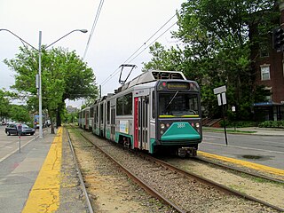
The E branch is a light rail line in Boston, Cambridge, Medford, and Somerville, Massachusetts, operating as part of the Massachusetts Bay Transportation Authority (MBTA) Green Line. The line runs in mixed traffic on South Huntington Avenue and Huntington Avenue between Heath Street and Brigham Circle, in the median of Huntington Avenue to Northeastern University, then into the Huntington Avenue subway. The line merges into the Boylston Street subway just west of Copley, running to North Station via the Tremont Street subway. It then follows the Lechmere Viaduct to Lechmere, then the Medford Branch to Medford/Tufts. As of February 2022, service operates on 7 to 7.5-minute headways on weekdays and 9-minute headways on weekends, using 12 to 15 trains.

As with many large cities, a large number of Boston-area streetcar lines once existed, and many continued operating into the 1950s. However, only a few now remain, namely the four branches of the Green Line and the Ashmont–Mattapan High-Speed Line, with only one running regular service on an undivided street.

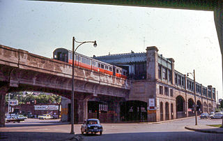
Community College station is a rapid transit station on the MBTA Orange Line in Boston, Massachusetts. It is located in the Charlestown neighborhood off Austin Street near New Rutherford Avenue (MA-99), under the double-decked elevated structure carrying Interstate 93 to the Zakim Bunker Hill Bridge. The station is named for the adjacent Bunker Hill Community College. The station opened in April 1975, replacing the City Square and Thompson Square stations of the Charlestown Elevated. It was made accessible around 2005.
The Washington Street Elevated was an elevated segment of Boston's Massachusetts Bay Transportation Authority subway system, comprising the southern stretch of the Orange Line. It ran from Chinatown through the South End and Roxbury, ending in Forest Hills in Jamaica Plain, Boston.

The Charlestown Elevated was a segment of the MBTA Orange Line rapid transit line that ran from the Canal Street Incline in downtown Boston, Massachusetts through Charlestown to a terminal in Everett, Massachusetts. It opened in June 1901 and was replaced by the Haymarket North Extension in April 1975.

The Tremont Street subway in Boston's MBTA subway system is the oldest subway tunnel in North America and the third oldest still in use worldwide to exclusively use electric traction, opening on September 1, 1897. It was originally built, under the supervision of Howard A. Carson as chief engineer, to get streetcar lines off the traffic-clogged streets, instead of as a true rapid transit line. It now forms the central part of the Green Line, connecting Boylston Street to Park Street and Government Center stations.
The Haymarket North Extension is a section of the Massachusetts Bay Transportation Authority's rapid transit Orange Line which currently constitutes the northern section of the line. It runs from North Station through an underground crossing of the Charles River, then along the Haverhill Line right-of-way to Oak Grove station in Malden, Massachusetts. Built to replace the Charlestown Elevated and originally intended to be extended as far as Reading, it opened in stages between 1975 and 1977.

The Massachusetts Bay Transportation Authority (MBTA) operates rapid transit, light rail, and bus rapid transit services in the Boston metropolitan area, collectively referred to as the rapid transit, subway, or the T system.

The Causeway Street elevated was an elevated section of the MBTA Green Line light rail system in Boston, located in the area near North Station. It was in operation from 1912 until 2004, when it was replaced with a new tunnel and underground station on a slightly different alignment.
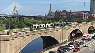
The Lechmere Viaduct is a concrete arch bridge connecting the West End neighborhood of Boston to East Cambridge, Massachusetts. Opened in 1912, the viaduct carries the MBTA's Green Line over the Charles River. It is adjacent to the Charles River Dam Bridge, but structurally separate.
North Station is an underground MBTA subway station in Boston, Massachusetts. Served by the Massachusetts Bay Transit Authority (MBTA) Green Line and Orange Line, it is connected to the North Station surface terminal used by MBTA Commuter Rail and Amtrak. The station is fully accessible.
