The North End is a neighborhood of Boston, Massachusetts, United States. It has the distinction of being the city's oldest residential community, which has been inhabited since it was colonized in the 1630s. It is only 0.36 square miles (0.93 km2), yet the neighborhood has nearly one hundred establishments and a variety of tourist attractions. It is known for its Italian American population and Italian restaurants.
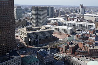
Government Center is an area in downtown Boston, centered on City Hall Plaza. Formerly the site of Scollay Square, it is now the location of Boston City Hall, courthouses, state and federal office buildings, and a major MBTA subway station, also called Government Center. Its development was controversial, as the project displaced thousands of residents and razed several hundred homes and businesses.

North Station is a commuter rail and intercity rail terminal station in Boston, Massachusetts. It is served by four MBTA Commuter Rail lines – the Fitchburg Line, Haverhill Line, Lowell Line, and Newburyport/Rockport Line – and the Amtrak Downeaster intercity service. The concourse is located under the TD Garden arena, with the platforms extending north towards drawbridges over the Charles River. The eponymous subway station, served by the Green Line and Orange Line, is connected to the concourse with an underground passageway.

Science Park station is an elevated light rail station on the Massachusetts Bay Transportation Authority (MBTA) Green Line in Boston, Massachusetts, United States. The station is located at the Boston end of the Charles River Dam Bridge at Leverett Circle. It is at the southeast end of the Lechmere Viaduct, which carries the Green Line over the Charles River. The station is named for the nearby Boston Museum of Science. With 873 daily boardings by a FY 2019 count, Science Park is the least-used fare-controlled station on the Green Line, and the second-lowest on the MBTA subway system after Suffolk Downs.

Lechmere station is a Massachusetts Bay Transportation Authority (MBTA) Green Line light rail station in Lechmere Square in East Cambridge, Massachusetts. It is located on the east side of Monsignor O'Brien Highway near First Street, adjacent to the NorthPoint development. The accessible elevated station has a single island platform, with headhouses at both ends. It opened on March 21, 2022, as part of the Green Line Extension (GLX). Lechmere station is served by Green Line D branch and E branch service.

The Rose Fitzgerald Kennedy Greenway is a linear park located in several Downtown Boston neighborhoods. It consists of landscaped gardens, promenades, plazas, fountains, art, and specialty lighting systems that stretch over one mile through Chinatown, the Financial District, the Waterfront, and North End neighborhoods. Officially opened in October 2008, the 17-acre Greenway sits on land created from demolition of the John F. Fitzgerald Expressway as part of the Big Dig project.
Dewey Square is a square in downtown Boston, Massachusetts which lies at the intersection of Atlantic Avenue, Summer Street, Federal Street, Purchase Street and the John F. Kennedy Surface Road, with the Central Artery (I-93) passing underneath in the Dewey Square Tunnel, which was built in the Big Dig. South Station is on the southeast corner of the square, with Amtrak and MBTA Commuter Rail services, as well as Red Line subway trains and Silver Line bus rapid transit underneath.

Haymarket Square is the historic name of a former town square in Boston, located between the North End, Government Center, the Bulfinch Triangle, and the West End. The square was a well-known feature of Boston from the mid-19th century to the mid-20th century, when the buildings around it were demolished to make way for the Central Artery and Government Center. The Haymarket produce market continues to operate at a location near the historic site of the square. The Haymarket MBTA station extends under the former site of the square.
The Canal Street incline was a ramp connecting two transit tunnels in Boston with surface and elevated lines. It was located in the Bulfinch Triangle between North Station and Haymarket Square in two blocks bounded by Canal Street to the west, Causeway Street to the north, Haverhill Street to the east, and Market Street to the south. The incline was the north end of the Tremont Street subway and the Washington Street Tunnel. Built in 1898, it remained in use until 2004 when the last connecting line was moved underground.

The Charlestown Elevated was a segment of the MBTA Orange Line rapid transit line that ran from the Canal Street Incline in downtown Boston, Massachusetts through Charlestown to a terminal in Everett, Massachusetts. It opened in June 1901 and was replaced by the Haymarket North Extension in April 1975.

The West End is a neighborhood of Boston, Massachusetts, United States, bounded generally by Cambridge Street to the south, the Charles River to the west and northwest, North Washington Street on the north and northeast, and New Sudbury Street on the east. Beacon Hill is to the south, North Point is across the Charles River to the north, Kendall Square is across the Charles River to the west, and the North End is to the east. A late 1950s urban renewal project razed a large Italian and Jewish enclave and displaced over 20,000 people in order to redevelop much of the West End and part of the neighboring Downtown neighborhood. After that, the original West End became increasingly non-residential, including part of Government Center as well as much of Massachusetts General Hospital and several high rise office buildings. More recently, however, new residential buildings and spaces, as well as new parks, have been appearing across the West End.

The Causeway Street elevated was an elevated section of the MBTA Green Line light rail system in Boston, located in the area near North Station. It was in operation from 1912 until 2004, when it was replaced with a new tunnel and underground station on a slightly different alignment.
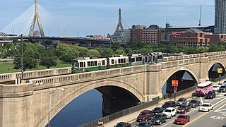
The Lechmere Viaduct is a concrete arch bridge connecting the West End neighborhood of Boston to East Cambridge, Massachusetts. Opened in 1912, the viaduct carries the MBTA's Green Line over the Charles River. It is adjacent to the Charles River Dam Bridge, but structurally separate.

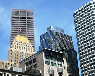
Downtown Boston is the central business district of Boston, Massachusetts, United States. Boston was founded in 1630. The largest of the city's commercial districts, Downtown is the location of many corporate or regional headquarters; city, county, state and federal government facilities; and many of Boston's tourist attractions. Similar to other central business districts in the U.S., Downtown has recently undergone a transformation that included the construction of new condos and lofts, renovation of historic buildings, and arrival of new residents and businesses. It is represented in the Boston City Council by District 2's Bill Linehan.

The North End Parks are the two northernmost parks on the Rose Kennedy Greenway, built over O'Neill Tunnel in Boston, Massachusetts and adjacent to the neighborhood known as the North End. Two landscape architecture firms designed the 3-acre (12,000 m2) North End Parks.

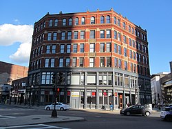
138–142 Portland Street is a historic commercial building located at the address of the same name in Boston, Massachusetts.

Hanover Street is located in the North End of Boston, Massachusetts.
The Bulfinch Companies, Inc. is an American real estate firm headquartered in Boston, Massachusetts.
The architecture of Boston is a robust combination of old and new architecture. As one of the oldest cities in North America, Boston, Massachusetts has accumulated buildings and structures ranging from the 17th-century to the present day, having evolved from a small port town to a large cosmopolitan center for education, industry, finance, and technology. The city is known for its granite buildings stemming from its early days. It is also known for being one of the origins of Federal Architecture.