Canal Uchusuma

Last updated

Canal Uchusuma
Txu-oclc-224300691-se19-6.jpg
Map of the general region, with the canal shown in the centre
Country Peru, Chile
Geography
DirectionSouthwest
Start point Uchusuma River
End pointRio Yungane
Beginning coordinates 17°34′00″S69°43′48″W / 17.56667°S 69.73000°W / -17.56667; -69.73000
Ending coordinates 17°46′04″S69°50′33″W / 17.76778°S 69.84250°W / -17.76778; -69.84250
Canal Uchusuma

Canal Uchusuma is a canal in Chile.

Geography

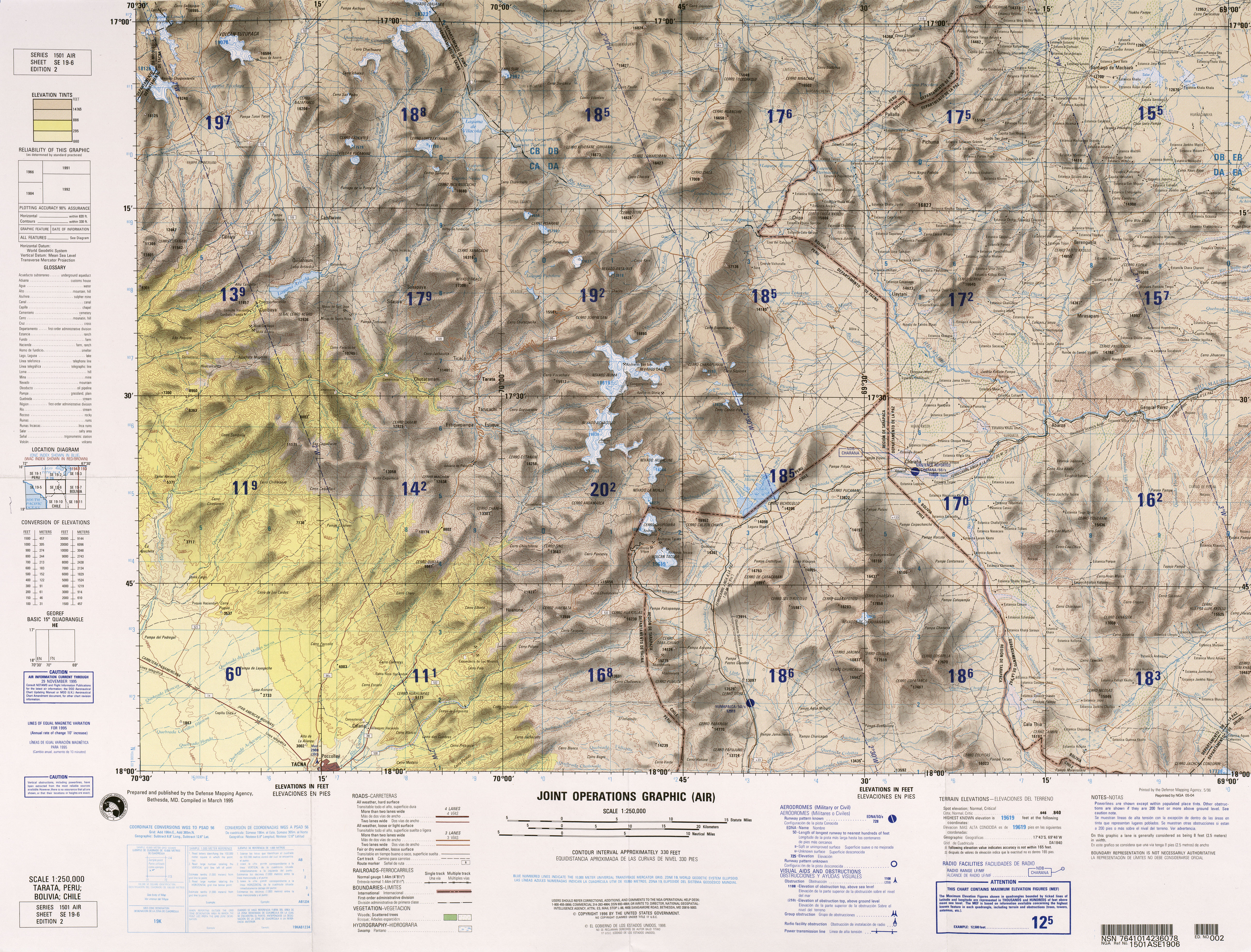
The canal begins at the northeastern foot of Cerro Huancune on the Uchusuma River, [1] a principal tributary of the Mauri River; [2] the diversion occurs at the locality Ancochaullanta at 4,460 metres (14,630 ft) elevation. [3] The path of the canal takes it southeastward through Peruvian territory until the Peru-Chile border at Laguna Blanca. It continues through Chilean territory from Laguna Blanca along the Arica–La Paz railway southwestward between the mountains Tacora and Caracarani, close to the Canal Mauri. It turns around Tacora's southern flank to its western side [1] while following a low-altitude moraine, [4] crosses the Rio Azufre westward and then the border between Chile and Peru. In Peru it continues southwestward and ends between the mountains of Cerro Huaylillas and Cerro Chulluncane into the Rio Yungane. [1] It does so by crossing the mountains through the Huaylillas Norte tunnel. The Rio Yungane subsequently joins the Quebrada Vilavilani. [3] The Quebrada Vilavilani descends the Andes in southwestward direction, where it has several different names, and ends close to the city of Tacna into the Caplina River. [1]

Contents

History

This canal was constructed in 1820. [3] There were numerous projects to expand the canal system to more water sources in the Mauri, [5] and the Canal Mauri was constructed in 1954. [3] According to a report in 1977, the Canal Uchusuma is still used when the other canal is under maintenance. [6]

Related Research Articles

<span class="mw-page-title-main">Jujuy Province</span> Province of Argentina

Jujuy is a province of Argentina, located in the extreme northwest of the country, at the borders with Chile and Bolivia. The only neighboring Argentine province is Salta to the east and south.

<span class="mw-page-title-main">Santa Cruz Province, Argentina</span> Province of Argentina

Santa Cruz Province is a province of Argentina, located in the southern part of the country, in Patagonia. It borders Chubut Province to the north, and Chile to the west and south, with an Atlantic coast on its east. Santa Cruz is the second-largest province of the country, and the least densely populated in mainland Argentina.

<span class="mw-page-title-main">Neuquén Province</span> Province of Argentina

Neuquén is a province of Argentina, located in the west of the country, at the northern end of Patagonia. It borders Mendoza Province to the north, Rio Negro Province to the southeast, and Chile to the west. It also meets La Pampa Province at its northeast corner.

<span class="mw-page-title-main">Ecuadorian–Peruvian War</span> 1941 South American border conflict

The Second Ecuadorian–Peruvian War, known locally as the War of '41, was a South American border war fought between 5–31 July 1941. It was the first of three military conflicts between Ecuador and Peru during the 20th century.

<span class="mw-page-title-main">Quebrada de Humahuaca</span> UNESCO World Heritage Site in Jujuy Province, Argentina

The Quebrada de Humahuaca is a narrow mountain valley located in the province of Jujuy in northwest Argentina, 1,649 km (1,025 mi) north of Buenos Aires. It is about 155 km (96 mi) long, oriented north–south, bordered by the Altiplano in the west and north, by the Sub-Andean hills in the east, and by the warm valleys in the south.

<span class="mw-page-title-main">Protected areas of Chile</span>

The protected areas of Chile are areas that have natural beauty or significant historical value protected by the government of Chile. These protected areas cover over 140,000 km2 (54,054 sq mi), which is 19% of the territory of Chile. The National System of Protected Wild Areas is regulated by law #18,362 passed in 1984, and administered by the National Forest Corporation (CONAF).

<span class="mw-page-title-main">Tacora</span> Stratovolcano in Parinacota Province, Chile

Tacora is a stratovolcano located in the Andes of the Arica y Parinacota Region of Chile. Near the border with Peru, it is one of the northernmost volcanoes of Chile. It is part of the Central Volcanic Zone in Chile, one of the four volcanic belts of the Andes. The Central Volcanic Zone has several of the highest volcanoes in the world. Tacora itself is a stratovolcano with a caldera and a crater. The youngest radiometric age is 50,000 years ago and it is heavily eroded by glacial activity.

<span class="mw-page-title-main">Argentina–Chile relations</span> Bilateral relations

International relations between the Republic of Chile and the Argentine Republic have existed for decades. The border between the two countries is the world's third-longest international border, which is 5,300 km (3,300 mi) long and runs from north to south along the Andes mountains. Although both countries gained their independence during the South American wars of liberation, during much of the 19th and the 20th century, relations between the countries were tense as a result of disputes over the border in Patagonia. Despite this, Chile and Argentina have never been engaged in a war with each other. In recent years, relations have improved. Argentina and Chile have followed quite different economic policies. Chile has signed free trade agreements with countries such as China, the United States, Canada, South Korea, as well as European Union, and it's a member of the APEC. Argentina belongs to the Mercosur regional free trade area. In April 2018, both countries suspended their membership from the UNASUR.

Hiking in Chile is characterized by a wide range of environments and climates for hikers, which largely results from Chile's unusual, ribbon-like shape, which is 4,300 kilometres long and on average 175 kilometres wide. These range from the world's driest desert, the Atacama, in the north, through a Mediterranean climate in the center, to the glaciers, fjords and lakes of Patagonia in the south.

<span class="mw-page-title-main">Treaty of Peace and Friendship (1904)</span> 1904 border demarcation treaty between Chile and Bolivia

The Treaty of Peace and Friendship of 1904 between Chile and Bolivia was signed in Santiago de Chile on 20 October 1904, to delineate the boundary through 96 specified points between Cerro Zapaleri and Cerro Chipe and to regulate the relations between the two countries 20 years after the end of the War of the Pacific.

Under UNESCO’s Man and the Biosphere Programme, there are 125 biosphere reserves recognized as part of the World Network of Biosphere Reserves in Latin America and the Caribbean. These are distributed across 21 countries in the region.

<span class="mw-page-title-main">Quilcayhuanca</span> Valley in the Ancash Region in Peru

Quilcayhuanca, Quillcay,Quilcay or Qelkaywanka is a river in the Ancash Region in Peru. It is a right affluent of the Santa River.

<span class="mw-page-title-main">Coropuna</span> Volcano in Peru

Coropuna is a dormant compound volcano located in the Andes mountains of southeast-central Peru. The upper reaches of Coropuna consist of several perennially snowbound conical summits, lending it the name Nevado Coropuna in Spanish. The complex extends over an area of 240 square kilometres (93 sq mi) and its highest summit reaches an altitude of 6,377 metres (20,922 ft) above sea level. This makes the Coropuna complex the third-highest of Peru. Its thick ice cap is the most extensive in Earth's tropical zone, with several outlet glaciers stretching out to lower altitudes. Below an elevation of 5,000 metres (16,000 ft), there are various vegetation belts which include trees, peat bogs, grasses and also agricultural areas and pastures.

<span class="mw-page-title-main">Olca-Paruma</span> Volcanic complex in Chile

Olca-Paruma is a volcanic complex in Chile. Lying on the border between Chile and Bolivia, it is formed by an east–west alignment of volcanoes. From west to east, these are Cerro Paruma, Volcan Paruma, Olca, and Mencheca or Michincha. Aside from the mines of Ujina, Rosario, and Quebrada Blanca, the area is sparsely populated.

<span class="mw-page-title-main">Isluga River</span> River

Isluga River is a river in Chile and Bolivia, and is also known as Sitani or Arabilla. It starts at the confluence of the rivers Chaguane and Huinchuta and flows for 54 kilometres (34 mi) before reaching the Laguna Mucalliri of the Salar de Coipasa. It receives water from the volcanoes Isluga, Cabaray and Quimsachata as well as the Sierra Uscana.

<span class="mw-page-title-main">Canal Mauri</span> Canal in Peru and Chile

Canal Mauri is a canal in Peru and Chile. It transfers water from the Mauri River watershed and transfers it into the Caplina River for irrigation purposes. An earlier canal Canal Uchusuma was constructed in the early 19th century and was replaced by the Canal Mauri. This canal collects water from several tributaries of the Mauri River and diverts it through Chilean territory into the Quebrada Vilavilani, a tributary of the Caplina River; from there it is later diverted for irrigation purposes in the Tacna region.

<span class="mw-page-title-main">Casiri (Tacna)</span> Volcano in Peru

Casiri, also known as Paucarani, is an about 5,650 metres (18,537 ft) high complex volcano in the Barroso mountain range of the Andes, in the Tacna Region of Peru. It consists of four individual volcanic edifices with lava domes; the southeasternmost edifice has been active during the Holocene, producing thick lava flows that have overrun moraines of Pleistocene age. The youngest lava flow has been dated to 2,600 ± 400 years ago. Although no historical eruptions are known, the volcano is considered to be potentially active and is monitored.

<span class="mw-page-title-main">Bolivian–Peruvian territorial dispute</span> Territorial dispute from 1825 to 1909

The Bolivian–Peruvian territorial dispute was a territorial dispute between Bolivia and Peru that lasted from the former's independence in 1825 to the signing of the Polo–Bustamante Treaty in 1909.

References

  1. 1 2 3 4 Tarata, Peru; Bolivia; Chile (Map) (2 ed.). 1:250000. Joint Operations Graphic. Defense Mapping Agency . Retrieved 27 February 2018.
  2. Ministry of Agriculture of Peru 1977, p. 5.
  3. 1 2 3 4 Ministry of Agriculture of Peru 1977, p. 13.
  4. Oregon State University. "Tacora". Volcano World. Archived from the original on 12 April 2018. Retrieved 27 February 2018.
  5. Ministry of Agriculture of Peru 1977, p. 2.
  6. Ministry of Agriculture of Peru 1977, p. 14.

Sources