Candiana | |
---|---|
Comune | |
Comune di Candiana | |
Coordinates: 45°13′N11°58′E / 45.217°N 11.967°E Coordinates: 45°13′N11°58′E / 45.217°N 11.967°E | |
Country | Italy |
Region | Veneto |
Province | Province of Padua (PD) |
Frazioni | Pontecasale |
Area | |
• Total | 22.2 km2 (8.6 sq mi) |
Population (Dec. 2004) | |
• Total | 2,468 |
• Density | 110/km2 (290/sq mi) |
Demonym(s) | Candianesi |
Time zone | CET (UTC+1) |
• Summer (DST) | CEST (UTC+2) |
Postal code | 35020 |
Dialing code | 049 |
Website | Official website |
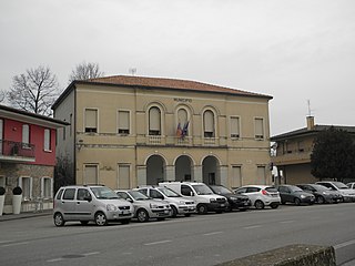
Candiana is a comune (municipality) in the Province of Padua in the Italian region Veneto, located about 35 kilometres (22 mi) southwest of Venice and about 25 kilometres (16 mi) southeast of Padua. As of 31 December 2004, it had a population of 2,468 and an area of 22.2 square kilometres (8.6 sq mi). [1]
The comune is a basic administrative division in Italy, roughly equivalent to a township or municipality.
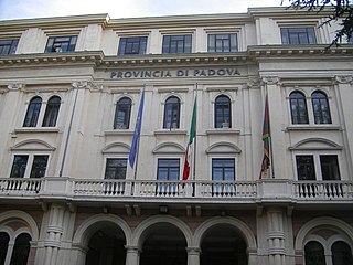
The Province of Padua is a province in the Veneto region of Italy. Its capital is the city of Padua.
Italy, officially the Italian Republic, is a country in Southern and Western Europe. Located in the middle of the Mediterranean Sea, Italy shares open land borders with France, Switzerland, Austria, Slovenia and the enclaved microstates San Marino and Vatican City. Italy covers an area of 301,340 km2 (116,350 sq mi) and has a largely temperate seasonal and Mediterranean climate. With around 61 million inhabitants, it is the fourth-most populous EU member state and the most populous country in Southern Europe.
The municipality of Candiana contains the frazione (subdivision) Pontecasale.
"Frazione" is the Italian name given in administrative law to a type of territorial subdivision of a comune; for other administrative divisions, see municipio, circoscrizione, quartiere. It is cognate to the English word fraction, but in practice is roughly equivalent to "parishes" or "wards" in other countries.
Candiana borders the following municipalities: Agna, Arre, Bovolenta, Correzzola, Pontelongo, Terrassa Padovana.
Agna is a town and commune in the province of Padua, in the Veneto region of northern Italy.
Bovolenta is a comune (municipality) in the Province of Padua in the Italian region Veneto, located about 35 kilometres (22 mi) southwest of Venice and about 15 kilometres (9 mi) southeast of Padua. As of 31 December 2004, it had a population of 3,127 and an area of 22.7 square kilometres (8.8 sq mi).
Correzzola is a comune (municipality) in the Province of Padua in the Italian region Veneto, located about 30 kilometres (19 mi) southwest of Venice and about 25 kilometres (16 mi) southeast of Padua. As of 31 December 2004, it had a population of 5,506 and an area of 42.5 square kilometres (16.4 sq mi).
Arre is a comune (municipality) in the Province of Padua in the Italian region Veneto, located about 40 kilometres (25 mi) southwest of Venice and about 25 kilometres (16 mi) south of Padua. As of 31 December 2004, it had a population of 2,067 and an area of 12.4 square kilometres (4.8 sq mi).
Boara Pisani is a comune (municipality) in the Province of Padua in the Italian region Veneto, located about 60 kilometres (37 mi) southwest of Venice and about 35 kilometres (22 mi) south of Padua. As of 31 December 2004, it had a population of 2,542 and an area of 16.5 square kilometres (6.4 sq mi).
Conselve is a comune (municipality) in the Province of Padua in the Italian region Veneto, located about 40 kilometres (25 mi) southwest of Venice and about 20 kilometres (12 mi) south of Padua. It has a population of 10,486 and an area of 24.2 square kilometres (9.3 sq mi).
Gazzo is a comune (municipality) in the Province of Padua in the Italian region Veneto, located about 50 kilometres (31 mi) northwest of Venice and about 25 kilometres (16 mi) northwest of Padua. As of 31 August 2017, it had a population of 4,302 and an area of 22.7 square kilometres (8.8 sq mi).
Limena is a comune (municipality) in the Province of Padua in the Italian region Veneto, located about 35 kilometres (22 mi) west of Venice and about 6 kilometres (4 mi) north of Padua. As of 31 December 2004, it had a population of 7,148 and an area of 15.0 square kilometres (5.8 sq mi).
Loreggia is a comune (municipality) in the Province of Padua in the Italian region Veneto, located about 35 kilometres (22 mi) northwest of Venice and about 20 kilometres (12 mi) northeast of Padua.
Megliadino San Vitale is a comune (municipality) in the Province of Padua in the Italian region Veneto, located about 70 kilometres (43 mi) southwest of Venice and about 35 kilometres (22 mi) southwest of Padua.
Piombino Dese is a comune (municipality) in the Province of Padua in the Italian region Veneto, located about 35 kilometres (22 mi) northwest of Venice and about 20 kilometres (12 mi) north of Padua.
Ponso is a comune (municipality) in the Province of Padua in the Italian region Veneto, located about 60 kilometres (37 mi) southwest of Venice and about 35 kilometres (22 mi) southwest of Padua. As of 31 December 2004, it had a population of 2,435 and an area of 10.9 square kilometres (4.2 sq mi).
Pontelongo is a comune (municipality) in the Province of Padua in the Italian region Veneto, located about 30 kilometres (19 mi) southwest of Venice and about 20 kilometres (12 mi) southeast of Padua. As of 31 December 2004, it had a population of 3,853 and an area of 10.8 square kilometres (4.2 sq mi).
San Giorgio delle Pertiche is a comune (municipality) in the Province of Padua in the Italian region Veneto, located about 35 kilometres (22 mi) northwest of Venice and about 14 kilometres (9 mi) northeast of Padua. As of 31 December 2004, it had a population of 8,617 and an area of 18.8 square kilometres (7.3 sq mi).
Santa Giustina in Colle is a comune (municipality) in the Province of Padua in the Italian region Veneto, located about 35 kilometres (22 mi) northwest of Venice and about 15 kilometres (9 mi) north of Padua. As of 31 December 2004, it had a population of 6,823 and an area of 17.9 square kilometres (6.9 sq mi).
Sant'Urbano is a comune (municipality) in the Province of Padua in the Italian region Veneto, located about 60 kilometres (37 mi) southwest of Venice and about 35 kilometres (22 mi) southwest of Padua. As of 31 December 2004, it had a population of 2,189 and an area of 31.8 square kilometres (12.3 sq mi).
Saonara is a comune (municipality) in the Province of Padua in the Italian region Veneto, located about 25 kilometres (16 mi) southwest of Venice and about 11 kilometres (7 mi) southeast of Padua. As of 31 December 2004, it had a population of 9,399 and an area of 13.5 square kilometres (5.2 sq mi).
Terrassa Padovana is a comune (municipality) in the Province of Padua in the Italian region Veneto, located about 40 kilometres (25 mi) southwest of Venice and about 20 kilometres (12 mi) south of Padua. As of 31 December 2004, it had a population of 2,321 and an area of 14.7 square kilometres (5.7 sq mi).
Vescovana is a comune (municipality) in the Province of Padua in the Italian region Veneto, located about 60 kilometres (37 mi) southwest of Venice and about 35 kilometres (22 mi) southwest of Padua. As of 31 December 2004, it had a population of 1,601 and an area of 22.3 square kilometres (8.6 sq mi).
Vigodarzere is a comune (municipality) in the Province of Padua in the Italian region Veneto, located about 35 kilometres (22 mi) west of Venice and about 4 kilometres (2 mi) northeast of Padua.
Villa Estense is a comune (municipality) in the Province of Padua in the Italian region Veneto, located about 60 kilometres (37 mi) southwest of Venice and about 30 kilometres (19 mi) southwest of Padua. As of 31 December 2004, it had a population of 2,407 and an area of 16.0 square kilometres (6.2 sq mi).
This article on a location in Veneto is a stub. You can help Wikipedia by expanding it. |