Canton of Bricquebec

Last updated
Bricquebec
Country France
Region Normandy
Department Manche
No. of communes27
SeatBricquebec
Area
  Total337.29 km2 (130.23 sq mi)
Population
 (2012)
  Total18,352
  Density54/km2 (140/sq mi)
INSEE code 50 04

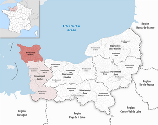
The Canton of Bricquebec in France is situated in the department of Manche and the region of Normandy. Bricquebec is also the name of its seat. At the French canton reorganisation which came into effect in March 2015, the canton was expanded from 14 to 33 communes (6 of which merged into the new commune Bricquebec-en-Cotentin): [1]

France Republic in Europe with several non-European regions

France, officially the French Republic, is a country whose territory consists of metropolitan France in Western Europe and several overseas regions and territories. The metropolitan area of France extends from the Mediterranean Sea to the English Channel and the North Sea, and from the Rhine to the Atlantic Ocean. It is bordered by Belgium, Luxembourg and Germany to the northeast, Switzerland and Italy to the east, and Andorra and Spain to the south. The overseas territories include French Guiana in South America and several islands in the Atlantic, Pacific and Indian oceans. The country's 18 integral regions span a combined area of 643,801 square kilometres (248,573 sq mi) and a total population of 67.02 million. France is a unitary semi-presidential republic with its capital in Paris, the country's largest city and main cultural and commercial centre. Other major urban areas include Lyon, Marseille, Toulouse, Bordeaux, Lille and Nice.

In the administrative divisions of France, the department is one of the three levels of government below the national level, between the administrative regions and the commune. Ninety-five departments are in metropolitan France, and five are overseas departments, which are also classified as regions. Departments are further subdivided into 334 arrondissements, themselves divided into cantons; the last two have no autonomy, and are used for the organisation of police, fire departments, and sometimes, elections.

Manche Department of France

Manche is a French department in Normandy (Normandie), named for the English Channel, which is known as La Manche, literally "the sleeve" in French. The department borders its northern and western shores and part of its eastern shore.

Besneville Commune in Normandy, France

Besneville is a commune in the Manche department in the Normandy region in northwestern France.

Biniville Commune in Normandy, France

Biniville is a commune in the Manche department in the Normandy region in northwestern France.

La Bonneville Commune in Normandy, France

La Bonneville is a commune in the Manche department in Normandy in northwestern France.

Related Research Articles

Arrondissement of Cherbourg Arrondissement in Normandy, France

The arrondissement of Cherbourg is an arrondissement of France in the Manche department in the Normandy region. Since the January 2017 reorganization of the arrondissements of Manche, it has 144 communes.

Bricquebec Part of Bricquebec-en-Cotentin in Normandy, France

Bricquebec is a former commune in the Manche department in Normandy in northwestern France. On 1 January 2016, it was merged into the new commune of Bricquebec-en-Cotentin.

The Canton of Barneville-Carteret in France is a former canton situated in the department of Manche and the region of Basse-Normandie. Barneville-Carteret was also the name of its seat. It was disbanded following the French canton reorganisation which came into effect in March 2015. It consisted of 14 communes, which joined the canton of Les Pieux in 2015.

This page lists the armoury of the communes in la Manche.

Bricquebec-en-Cotentin Commune in Normandy, France

Bricquebec-en-Cotentin is a commune in the department of Manche, northwestern France. The municipality was established on 1 January 2016 by merger of the former communes of Bricquebec, Les Perques, Quettetot, Saint-Martin-le-Hébert, Le Valdécie and Le Vrétot.

The canton of Avranches is an administrative division of the Manche department, northwestern France. Its borders were modified at the French canton reorganisation which came into effect in March 2015. Its seat is in Avranches.

The canton of Bréhal is an administrative division of the Manche department, northwestern France. Its borders were modified at the French canton reorganisation which came into effect in March 2015. Its seat is in Bréhal.

The canton of Cherbourg-Octeville-1 is an administrative division of the Manche department, northwestern France. It was created at the French canton reorganisation which came into effect in March 2015. Its seat is in Cherbourg-en-Cotentin.

The canton of Cherbourg-Octeville-2 is an administrative division of the Manche department, northwestern France. It was created at the French canton reorganisation which came into effect in March 2015. Its seat is in Cherbourg-en-Cotentin.

The canton of Cherbourg-Octeville-3 is an administrative division of the Manche department, northwestern France. It was created at the French canton reorganisation which came into effect in March 2015. Its seat is in Cherbourg-en-Cotentin.

The canton of Équeurdreville-Hainneville is an administrative division of the Manche department, northwestern France. Its borders were modified at the French canton reorganisation which came into effect in March 2015. Its seat is in Cherbourg-en-Cotentin.

The canton of La Hague is an administrative division of the Manche department, northwestern France. It was created at the French canton reorganisation which came into effect in March 2015. Its seat is in Cherbourg-en-Cotentin.

The canton of Tourlaville is an administrative division of the Manche department, northwestern France. Its borders were modified at the French canton reorganisation which came into effect in March 2015. Its seat is in Cherbourg-en-Cotentin.

The canton of Condé-sur-Vire is an administrative division of the Manche department, northwestern France. It was created at the French canton reorganisation which came into effect in March 2015. Its seat is in Condé-sur-Vire.

The canton of Le Mortainais is an administrative division of the Manche department, northwestern France. It was created at the French canton reorganisation which came into effect in March 2015. Its seat is in Mortain-Bocage.

The canton of Les Pieux is an administrative division of the Manche department, northwestern France. Its borders were modified at the French canton reorganisation which came into effect in March 2015. Its seat is in Les Pieux.

The canton of Pont-Hébert is an administrative division of the Manche department, northwestern France. It was created at the French canton reorganisation which came into effect in March 2015. Its seat is in Pont-Hébert.

The canton of Valognes is an administrative division of the Manche department, northwestern France. Its borders were modified at the French canton reorganisation which came into effect in March 2015. Its seat is in Valognes.

The canton of Val-de-Saire is an administrative division of the Manche department, northwestern France. It was created at the French canton reorganisation which came into effect in March 2015. Its seat is in Saint-Vaast-la-Hougue.

Communauté d'agglomération du Cotentin is the communauté d'agglomération, an intercommunal structure, centred on the city of Cherbourg-en-Cotentin, on the Cotentin Peninsula. It is located in the Manche department, in the Normandy region, northwestern France. It was created in January 2017 by the merger of 9 communautés de communes and the 2 new communes Cherbourg-en-Cotentin and La Hague. Its population was 187,335 in 2014, of which 83,790 in Cherbourg-en-Cotentin proper.

References

Coordinates: 49°28′14″N1°37′50″W / 49.47056°N 1.63056°W / 49.47056; -1.63056

Geographic coordinate system Coordinate system

A geographic coordinate system is a coordinate system that enables every location on Earth to be specified by a set of numbers, letters or symbols. The coordinates are often chosen such that one of the numbers represents a vertical position and two or three of the numbers represent a horizontal position; alternatively, a geographic position may be expressed in a combined three-dimensional Cartesian vector. A common choice of coordinates is latitude, longitude and elevation. To specify a location on a plane requires a map projection.