Picauville

Last updated

Picauville
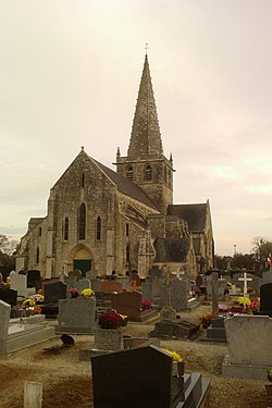
Eglise Saint-Candide de Picauville (4).jpg
The church of Saint-Candide
Blason ville fr Picauville (Manche).svg
Location of Picauville
Picauville
France location map-Regions and departements-2016.svg
Red pog.svg
Picauville
Normandie region location map.svg
Red pog.svg
Picauville
Coordinates: 49°22′46″N1°24′01″W / 49.3794°N 1.4002°W / 49.3794; -1.4002
Country France
Region Normandy
Department Manche
Arrondissement Cherbourg
Canton Carentan-les-Marais
Intercommunality Baie du Cotentin
Government
  Mayor (20202026) Marie-Hélène Perrotte [1]
Area
1
64.89 km2 (25.05 sq mi)
Population
 (2022) [2]
3,222
  Density50/km2 (130/sq mi)
Time zone UTC+01:00 (CET)
  Summer (DST) UTC+02:00 (CEST)
INSEE/Postal code
50400 /50360
Elevation2–30 m (6.6–98.4 ft)
(avg. 26 m or 85 ft)
1 French Land Register data, which excludes lakes, ponds, glaciers > 1 km2 (0.386 sq mi or 247 acres) and river estuaries.

Picauville (French pronunciation: [pikovil] ) is a commune in the Manche department in Normandy in north-western France. On 1 January 2016, the former communes of Amfreville, Cretteville, Gourbesville, Houtteville and Vindefontaine were merged into Picauville. [3] On 1 January 2017, the former commune of Les Moitiers-en-Bauptois was merged into Picauville. [4] The inhabitants are called Picauvillais. Picauville also has a 17th-century castle, classified as a historical landmark by the French government, called the Isle-Marie Castle. Parts of the structure date to the 11th century.

Contents

Population

Historical population
YearPop.±% p.a.
1968 4,250    
1975 4,190−0.20%
1982 3,949−0.84%
1990 3,523−1.42%
1999 3,294−0.74%
2007 3,399+0.39%
2012 3,412+0.08%
2017 3,278−0.80%
Source: INSEE [5]

Heraldry

Arms of Picauville Blason ville fr Picauville (Manche).svg
Arms of Picauville
The arms of Picauville are blazoned  :
Or, a crown of thorns sable between 3 mallets vert, and on a chief gules a leopard Or.


World War II

Picauville was one of the first towns liberated by Allied forces following the Normandy landings in early June 1944; German General Wilhelm Falley was killed there by an American paratrooper shortly after the invasion began. Engineers of the Ninth Air Force IX Engineering Command began construction of a combat Advanced Landing Ground to the northwest of the town. Declared operational on 26 June, the airfield was designated as "A-8", it was used by the 405th Fighter Group which flew P-47 Thunderbolts until mid-September when the unit moved to St. Dizier, near Nancy. [6] Afterward, the airfield was closed. [7] [8] A cairn marking the location of the airfield is on the east side of the D69, 2.3 km outside of Picauville on the way to Gourbesville (49°23'34.19"N, 1°25'07.69"E). [9]

See also

References

  1. "Répertoire national des élus: les maires" (in French). data.gouv.fr, Plateforme ouverte des données publiques françaises. 13 September 2022.
  2. "Populations de référence 2022" (in French). The National Institute of Statistics and Economic Studies. 19 December 2024.
  3. Arrêté préfectoral 23 December 2015 (in French)
  4. Arrêté préfectoral 4 July 2016 (in French)
  5. Population en historique depuis 1968, INSEE
  6. Nolte, Reginald G. Thunder Monsters Over Europe: A History of the 405th Fighter Group in World War II, Sunflower University Press, 1986, ISBN   0-89745-075-2.
  7. Johnson, David C. U.S. Army Air Forces Continental Airfields (ETO), D-Day to V-E Day; Research Division, USAF Historical Research Center, Maxwell AFB, Alabama, 1988.
  8. Maurer, Maurer. Air Force Combat Units of World War II. Maxwell AFB, Alabama: Office of Air Force History, 1983. ISBN   0-89201-092-4.
  9. http://www.normandie44lamemoire.com/versionanglaise/fichesvillesus/picauvilleus2.html Archived 2010-11-28 at the Wayback Machine retrieved January 18, 2010, and Google Earth.