Laulne | |
|---|---|
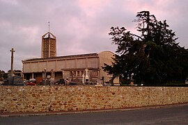 The church of Saint-Cyr-et-Sainte-Julitte | |
Location of Laulne  | |
 Laulne  Laulne | |
| Coordinates: 49°14′45″N1°27′28″W / 49.2458°N 1.4578°W | |
| Country | France |
| Region | Normandy |
| Department | Manche |
| Arrondissement | Coutances |
| Canton | Créances |
| Government | |
| • Mayor (2020–2026) | Denis Pépin [1] |
Area 1 | 9.06 km2 (3.50 sq mi) |
| Population (2022) [2] | 185 |
| • Density | 20/km2 (53/sq mi) |
| Time zone | UTC+01:00 (CET) |
| • Summer (DST) | UTC+02:00 (CEST) |
| INSEE/Postal code | 50265 /50430 |
| Elevation | 13–103 m (43–338 ft) (avg. 50 m or 160 ft) |
| 1 French Land Register data, which excludes lakes, ponds, glaciers > 1 km2 (0.386 sq mi or 247 acres) and river estuaries. | |
Laulne is a commune in the Manche department in north-western France.