
The arrondissement of Lunéville is an arrondissement of France in the Meurthe-et-Moselle department in the Grand Est region. It has 164 communes. Its population is 78,662 (2016), and its area is 1,450.7 km2 (560.1 sq mi).
The arrondissement of Nancy is an arrondissement of France in the Meurthe-et-Moselle department in the Grand Est region. It has 188 communes. Its population is 419,699 (2016), and its area is 1,509.4 km2 (582.8 sq mi).
The arrondissement of Toul is an arrondissement of France in the Meurthe-et-Moselle department in the Grand Est region. It has 111 communes. Its population is 69,151 (2016), and its area is 1,143.0 km2 (441.3 sq mi).
The arrondissement of Boulay-Moselle is a former arrondissement of France in the Moselle department in the Lorraine region. In 2015 it was merged into the new arrondissement of Forbach-Boulay-Moselle. It had 96 communes, and its population was 79,847 (2012).

The arrondissement of Château-Salins is a former arrondissement of France in the Moselle department in the Lorraine region. In January 2016 it was merged into the new arrondissement of Sarrebourg-Château-Salins. It had 128 communes, and its population was 29,818 (2012).

The arrondissement of Forbach is a former arrondissement of France in the Moselle department in the Lorraine region. In 2015 it was merged into the new arrondissement of Forbach-Boulay-Moselle. It had 73 communes, and its population was 167,518 (2012).

The arrondissement of Metz-Campagne is a former arrondissement of France in the Moselle department in the Lorraine region. In 2015 it was merged into the new arrondissement of Metz. It had 142 communes, and its population was 222,352 (2012).

The arrondissement of Sarrebourg is a former arrondissement of France in the Moselle department in the Lorraine region. In January 2016 it was merged into the new arrondissement of Sarrebourg-Château-Salins. It had 102 communes, and its population was 64,374 (2012).

The arrondissement of Thionville-Est is a former arrondissement of France in the Moselle department in the Lorraine region. In 2015 it was merged into the new arrondissement of Thionville. It had 75 communes, and its population was 79,847 (2012).
The arrondissement of Thionville-Ouest is a former arrondissement of France in the Moselle department in the Lorraine region. In 2015 it was merged into the new arrondissement of Thionville. It had 30 communes, and its population was 121,927 (2012).
The arrondissement of Metz-Ville is a former arrondissement of France in the Moselle department in the Lorraine region. In 2015 it was merged into the new arrondissement of Metz. It had 1 commune, and its population was 119,551 (2012).

The arrondissement of Épinal is an arrondissement of France in the Vosges department in the Grand Est region. It has 236 communes. Its population is 204,222 (2016), and its area is 2,598.2 km2 (1,003.2 sq mi).

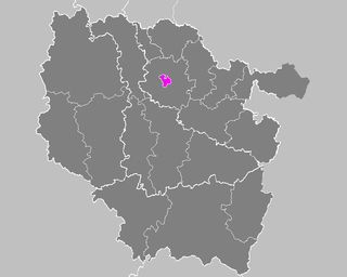
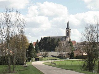
Delme is a commune in the Moselle department in Grand Est in north-eastern France. It was the center of the canton of Delme until 2015. It had a population of 989 in 2010.
Insming is a commune in the Moselle department in Grand Est in north-eastern France.
The Canton of Chaulnes is a former canton situated in the department of the Somme and in the Picardie region of northern France. It was disbanded following the French canton reorganisation which came into effect in March 2015. It consisted of 22 communes, which joined the canton of Ham in 2015.
The Canton of Oisemont is a former canton situated in the department of the Somme and in the Picardy region of northern France. It was disbanded following the French canton reorganisation which came into effect in March 2015. It consisted of 31 communes, which joined the canton of Poix-de-Picardie in 2015.
The Canton of Clères is a former canton situated in the Seine-Maritime département and in the Haute-Normandie region of northern France. It was disbanded following the French canton reorganisation which came into effect in March 2015.
The Canton of Châtel-sur-Moselle is a French former administrative and electoral grouping of communes in the Vosges département of eastern France and in the region of Lorraine. It covered an area directly to the north-west of Épinal. It was disbanded following the French canton reorganisation which came into effect in March 2015.
The Canton of Saulzais-le-Potier is a former canton situated in the Cher département and in the Centre region of France. It was disbanded following the French canton reorganisation which came into effect in March 2015. It consisted of 17 communes, which joined the canton of Châteaumeillant in 2015.
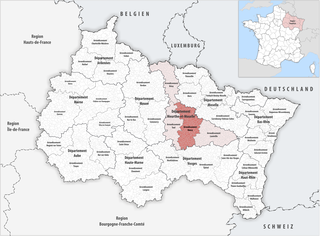
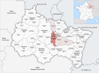
The canton of Le Saulnois is an administrative division of the Moselle department, northeastern France. Its borders were modified at the French canton reorganisation which came into effect in March 2015. Its seat is in Château-Salins.
