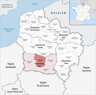
The arrondissement of Clermont is an arrondissement of France in the Oise departement in the Hauts-de-France region. It has 146 communes. Its population is 130,333 (2016), and its area is 1,141.7 km2 (440.8 sq mi).

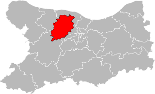
The arrondissement of Senlis is an arrondissement of France in the Oise department in the Hauts-de-France region. It has 132 communes. Its population is 281,760 (2016), and its area is 1,344.2 km2 (519.0 sq mi).
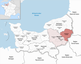
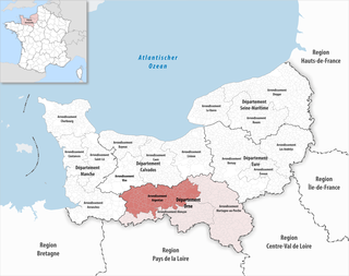
The arrondissement of Les Andelys is an arrondissement of France in the Eure department in the Normandy region. It has 185 communes. Its population is 235,732 (2016), and its area is 1,854.4 km2 (716.0 sq mi).

The arrondissement of Bernay is an arrondissement of France in the Eure department in the Normandy region. It has 297 communes. Its population is 227,054 (2016), and its area is 3,226.7 km2 (1,245.8 sq mi).
The arrondissement of Argentan is an arrondissement of France, located in the Orne department, region of Normandy. It has 123 communes. Its population is 110,239 (2016), and its area is 1,904.1 km2 (735.2 sq mi).
The following is a list of the 21 cantons of the Oise department, in France, following the French canton reorganisation which came into effect in March 2015:
The following is a list of the 23 cantons of the Var department, in France, following the French canton reorganisation which came into effect in March 2015:

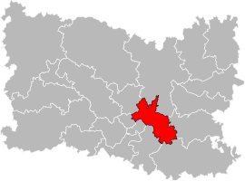
Pont-Sainte-Maxence is a commune in the Oise department in northern France, in the region of Hauts-de-France. It is named after Saint Maxentia of Beauvais, whose relics were taken here. Pont-Sainte-Maxence station has rail connections to Saint-Quentin, Compiègne, Creil and Paris.

The canton of Ribemont is an administrative division in northern France. At the French canton reorganisation which came into effect in March 2015, the canton was expanded from 15 to 52 communes:
The canton of Saint-Porchaire is an administrative division of the Charente-Maritime department, western France. Its borders were modified at the French canton reorganisation which came into effect in March 2015. Its seat is in Saint-Porchaire.
The canton of Thue et Mue is an administrative division of the Calvados department, northwestern France. It was created at the French canton reorganisation which came into effect in March 2015. Its seat is in Thue et Mue.

The canton of Pont-l'Évêque is an administrative division of the Calvados department, northwestern France. Its borders were modified at the French canton reorganisation which came into effect in March 2015. Its seat is in Pont-l'Évêque.
The canton of Vire Normandie is an administrative division of the Calvados department, northwestern France. Its borders were modified at the French canton reorganisation which came into effect in March 2015. Its seat is in Vire Normandie.
The canton of Athis-Val de Rouvre is an administrative division of the Orne department, northwestern France. Its borders were modified at the French canton reorganisation which came into effect in March 2015. Its seat is in Athis-Val de Rouvre.
The canton of Magny-le-Désert is an administrative division of the Orne department, northwestern France. It was created at the French canton reorganisation which came into effect in March 2015. Its seat is in Magny-le-Désert.
The canton of Semur-en-Auxois is an administrative division of the Côte-d'Or department, eastern France. Its borders were modified at the French canton reorganisation which came into effect in March 2015. Its seat is in Semur-en-Auxois.
The canton of Ornans is an administrative division of the Doubs department, eastern France. Its borders were modified at the French canton reorganisation which came into effect in March 2015. Its seat is in Ornans.
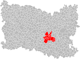
The Communauté de communes des Pays d'Oise et d'Halatte is a communauté de communes located in the Oise département and in the Hauts-de-France région of France. It was created in December 1997 and its seat is Pont-Sainte-Maxence. It includes 17 communes with a population of about 34,000 inhabitants.
The canton of Argonne Suippe et Vesle is an administrative division of the Marne department, northeastern France. It was created at the French canton reorganisation which came into effect in March 2015. Its seat is in Sainte-Menehould.

The metre gauge railway from Fleurines and Villers-Saint-Frambourg to Pont-Sainte-Maxence was a 8.2 km (5.1 mi) long light railway with a gauge of 1,000 mm running from the sand pits at Fleurines and Villers-Saint-Frambourg to the wharf at Pont-Sainte-Maxence on the River Oise in the department Oise in the Hauts-de-France region of France.