
Vigneux-sur-Seine is a commune in the southern suburbs of Paris, France. It is located 17.6 km (10.9 mi) from the center of Paris.

The arrondissement of Évry is an arrondissement of France in the Essonne department in the Île-de-France region. It has 52 communes.
The following is a list of the 21 cantons of the Essonne department, in France, following the French canton reorganisation which came into effect in March 2015:

The canton of Fontainebleau is a French administrative division, located in the arrondissement of Fontainebleau, in the Seine-et-Marne département.

The canton of Claye-Souilly is a French administrative division, located in the arrondissement of Torcy, in the Seine-et-Marne département.
The 8th constituency of Essonne is a French legislative constituency in the Essonne department. Its member of the National Assembly has been Nicolas Dupont-Aignan since 1997.
The canton of Fontenay-Trésigny is an administrative division of the Seine-et-Marne department, in northern France. It was created at the French canton reorganisation which came into effect in March 2015. Its seat is in Fontenay-Trésigny.
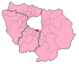
The canton of Arpajon is an administrative division of the Essonne department, Île-de-France region, northern France. Its borders were modified at the French canton reorganisation which came into effect in March 2015. Its seat is in Arpajon.
The canton of Brétigny-sur-Orge is an administrative division of the Essonne department, Île-de-France region, northern France. Its borders were modified at the French canton reorganisation which came into effect in March 2015. Its seat is in Brétigny-sur-Orge.
The canton of Draveil is an administrative division of the Essonne department, Île-de-France region, northern France. Its borders were modified at the French canton reorganisation which came into effect in March 2015. Its seat is in Draveil.
The canton of Épinay-sous-Sénart is an administrative division of the Essonne department, Île-de-France region, northern France. Its borders were modified at the French canton reorganisation which came into effect in March 2015. Its seat is in Épinay-sous-Sénart.
The canton of Étampes is an administrative division of the Essonne department, Île-de-France region, northern France. Its borders were modified at the French canton reorganisation which came into effect in March 2015. Its seat is in Étampes.
The canton of Gif-sur-Yvette is an administrative division of the Essonne department, Île-de-France region, northern France. Its borders were modified at the French canton reorganisation which came into effect in March 2015. Its seat is in Gif-sur-Yvette.
The canton of Longjumeau is an administrative division of the Essonne department, Île-de-France region, northern France. Its borders were modified at the French canton reorganisation which came into effect in March 2015. Its seat is in Longjumeau.
The canton of Mennecy is an administrative division of the Essonne department, Île-de-France region, northern France. Its borders were modified at the French canton reorganisation which came into effect in March 2015. Its seat is in Mennecy.
The canton of Sainte-Geneviève-des-Bois is an administrative division of the Essonne department, Île-de-France region, northern France. Its borders were modified at the French canton reorganisation which came into effect in March 2015. Its seat is in Sainte-Geneviève-des-Bois.
The canton of Savigny-sur-Orge is an administrative division of the Essonne department, Île-de-France region, northern France. Its borders were modified at the French canton reorganisation which came into effect in March 2015. Its seat is in Savigny-sur-Orge.
The Communauté d'agglomération Grand Paris Sud Seine-Essonne-Sénart is the communauté d'agglomération, an intercommunal structure, in the southern suburbs of Paris. It is located in the Essonne and Seine-et-Marne departments, in the Île-de-France region, northern France. It was created in January 2016. Its population was 347,022 in 2014. Its seat is in Courcouronnes.
Communauté d'agglomération Val d'Yerres Val de Seine is the communauté d'agglomération, an intercommunal structure, covering southern suburbs of Paris. It is located in the Essonne department, in the Île-de-France region, northern France. It was created in January 2016. Its population was 177,769 in 2014. Its seat is in Brunoy.

