Tahara is a city in Aichi Prefecture, Japan. As of 1 October 2019, the city had an estimated population of 60,206 in 22,576 households, and a population density of 315 persons per km2. The total area of the city is 191.12 square kilometres (73.79 sq mi).
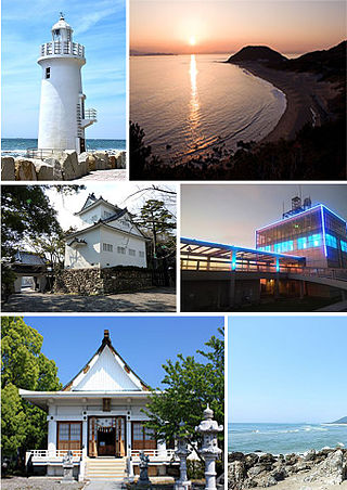
Minamichita is a town in Chita District, Aichi Prefecture, Japan. As of 1 October 2019, the town had an estimated population of 17,393 in 7338 households, and a population density of 453 persons per km2. The total area of the town was 38.37 square kilometres (14.81 sq mi).

Matsushima (松島) is a group of islands in Miyagi Prefecture, Japan. There are some 260 tiny islands (shima) covered in pines (matsu) – hence the name – and it is considered to be one of the Three Views of Japan.

The Miura Peninsula is a peninsula located in Kanagawa, Japan. It lies south of Yokohama and Tokyo and divides Tokyo Bay, to the east, from Sagami Bay, to the west. Cities and towns on the Miura Peninsula include Yokosuka, Miura, Hayama, Zushi, and Kamakura. The northern limit of the peninsula runs from Koshigoe, Kamakura in the west, across to Mt. Enkai, in the southern wards of Yokohama in the east, overlooking Tokyo Bay.

Shiretoko Peninsula is located on the easternmost portion of the Japanese island of Hokkaidō, protruding into the Sea of Okhotsk. It is separated from Kunashir Island, which is now occupied by Russia, by the Nemuro Strait. The name Shiretoko is derived from the Ainu word sir etok, meaning "the end of the Earth" or "the place where the Earth protrudes". The towns of Rausu and Shari are found on the peninsula.

The Shakotan Peninsula in Shiribeshi, on the west coast of Hokkaidō, Japan, is a mountainous peninsula which projects some 30 kilometres (19 mi) into the Sea of Japan. The Shakotan Peninsula forms part of the Niseko-Shakotan-Otaru Kaigan Quasi-National Park.

The Ōsumi Peninsula projects south from the Japanese island of Kyūshū and includes the southernmost point on the island, Cape Sata. Its east coast lies on the Pacific Ocean, while to the west it faces the Satsuma Peninsula across Kagoshima Bay. Politically it is part of Kagoshima Prefecture. Lava erupted in 1914 by Sakurajima made a land connection with the northwest of the Ōsumi Peninsula.

The Tsugaru Peninsula is a peninsula in Aomori Prefecture, at the northern end of Honshū island, Japan. The peninsula projects north into the Tsugaru Strait separating Honshū from Hokkaidō. The western coast is on the Sea of Japan, while on its eastern coast are Aomori Bay and Mutsu Bay. The peninsula is bisected from Cape Tappi at its northern end to the Hakkōda Mountains on its southern end by the Tsugaru Mountains. Across the Tsugaru strait to the north is Hokkaidō's Matsumae Peninsula, to which it is linked by the Seikan Tunnel.

The Nemuro Peninsula is a peninsula which extends from the east coast of Hokkaidō, Japan. It is some 30 kilometres (19 mi) long and 8 kilometres (5.0 mi) wide, and forms part of Nemuro City. Cape Nosappu at its tip is the easternmost point of Hokkaidō. The northern coastline is on Nemuro Bay, while the south faces the Pacific Ocean. Islands of the Habomai (Khabomai) Archipelago, administered by Russia but claimed by Japan, extend eastward from the peninsula.
The Ise-Shima (伊勢志摩) region of Japan, also called the Shima Peninsula, refers to the areas of eastern Mie Prefecture in or around Ise-Shima National Park, which include the cities Ise, Toba, Shima, and parts of the town of Minami-Ise. The area thrives on tourism, with many resort hotels and beaches in the area. Ise-Shima is also famed for fresh seafood, particular oysters.

The Aguni Islands are a group of islands in Okinawa Prefecture, Japan. They are about 60 km west of Okinawa Island.
Tourism Areas are areas or zones designated by the Japan Tourism Agency from 2008. As of April 2009, 30 Tourism Areas are located throughout Japan. The Japan Tourism Agency set the law in 2008 regarding this area to support and promote more synergistic activities among local governments, tourism associations, tourism industries and local hotels and other local organizations and individuals.
Shimokita Hantō Quasi-National Park is a quasi-national park in the Shimokita Peninsula of Aomori Prefecture in the Tōhoku region of far northern Honshū in Japan. It is rated a protected landscape according to the IUCN. The park, consists of several discontinuous locations, which include:

Atsumi Peninsula is a peninsula in southern Aichi Prefecture, central Honshū, Japan.

Ōshima is a rocky island off the northern coast of Natsudomari Peninsula in Mutsu Bay. The island is a part of Hiranai in Aomori Prefecture. The island has 3 km (1.9 mi) of coastline and an area of 0.16 km2 (0.062 sq mi). It is a part of the prefecture-maintained, Asamushi-Natsudomari Prefectural Natural Park.
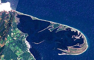
Notsuke Peninsula is a peninsula on the east coast of Hokkaidō, Japan, with its northwestern base in Shibetsu and southeast tip in Betsukai. The name is derived from the Ainu for jawbone, notkeu (ノッケウ), purportedly due to the landform's visual resemblance to that of a whale. The curved peninsula, the longest sandspit in the country, with a length of some 26 kilometres (16 mi) to 28 kilometres (17 mi), extends into the Nemuro Strait, which lies between Shiretoko Peninsula, Nemuro Peninsula, and the disputed island of Kunashiri in the Sea of Okhotsk; it was formed by the deposition of sand sediment carried by the currents in the strait, and itself forms and largely encloses Notsuke Bay. There remain on the peninsula traces of Satsumon culture pit dwellings, while during the Edo period samurai were stationed at a checkpoint controlling the crossing to Kunashiri. It is said that from the Edo period to the beginning of the Meiji period there was a settlement known as Kiraku (キラク) at the tip of the peninsula, with streets lined with samurai residences and even pleasure quarters, but this is not shown on contemporary maps and is poorly attested in the literature. Prominent features today include withered and eroded stretches of Sakhalin fir at Todowara and Mongolian oak at Narawara (ナラワラ), while to be found in the Notsuke Peninsula Primeval Flower Garden near Notsukezaki Lighthouse towards the eastern tip are the Kamchatka lily, Japanese iris, sea pea, Rosa rugosa, Eriophorum vaginatum, and Hemerocallis esculenta. The c.15 kilometres (9.3 mi) stretch of Hokkaido Prefectural Road Route 950 from the base of the peninsula to the nature centre is commonly known as the "Flower Road" (フラワーロード). Together with Notsuke Bay, Notsuke Peninsula has been designated a Ramsar Site, a Special Wildlife Protection Area, and an Important Bird Area, and forms part of Notsuke-Fūren Prefectural Natural Park.

The Wajima Museum of Urushi Art is a museum located in Wajima, Japan. The museum specializes in lacquer art.


