

Cape Three Forks, Cape des Trois Fourches, or Cape Tres Forcas is a headland on the Mediterranean coast of northeastern Morocco.
Cape Three Forks, Cape des Trois Fourches, or Cape Tres Forcas is a headland on the Mediterranean coast of northeastern Morocco.
The cape is a large mountainous promontory of North Africa into the Mediterranean Sea. For centuries, this cape has provided both a nautical landmark and a maritime hazard for ships in the Alboran Sea. The Spanish exclave of Melilla surrounds a smaller cape on the eastern side of the peninsula.

In antiquity, the cape was known to the Phoenicians and Carthaginians as Rusadir (Punic : 𐤓𐤔𐤀𐤃𐤓, ršʾdr), [1] giving its name to a nearby port (now Melilla). The name meant "Powerful" [2] or "High Cape", [3] but can also be understood as "Cape of the Powerful One", in reference to Baal, Tanit, and other important Punic deities. [4] [5] It was known to the Romans as Cape Metagonites (Latin : Metagonites Promontorium). [6] [7]
Cape Three Forks is known in Spanish as Cabo de Tres Forcas, in French as Cap des Trois Fourches, and in Arabic as Raʾs ith-Thalāth ash-Shawkāt or Raʾs Thalātha Madari, all meaning "Cape of the Three Forks".
It was also known in Arabic as "Raʾs Uarc". [8]
On 26 August 1923 the España ran aground and eventually wrecked on the cape. [9] [10]

A lighthouse is located in the north end of the cape. It is a gray tower on white two-story dwelling.
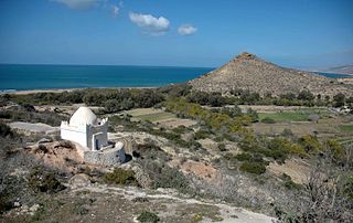
At least 11 locations in the Cape Three Forks have been identified as places of pious reflection, either small hermitages, bushes or trees, five of them featuring the tomb of the marabout. [11]
| Designations | |
|---|---|
| Official name | Cap des Trois Fourches |
| Designated | 15 January 2005 |
| Reference no. | 1473 [12] |
Cape Three Forks is a Ramsar designated site with no. 1473. It hosts different species, some of them threatened, such as the monk seal, two species of limpets ( Patella ferruginea and Patella nigra ), the loggerhead turtle, the fin whale and two species of dolphin ( Tursiops truncatus and Delphinus delphis ). The main activities taking place in the area are fishing and tourism. [13]

Melilla is an autonomous city of Spain on the North African coast. It lies on the eastern side of the Cape Three Forks, bordering Morocco and facing the Mediterranean Sea. It has an area of 12.3 km2 (4.7 sq mi). It was part of the Province of Málaga until 14 March 1995, when the Statute of Autonomy of Melilla was passed.
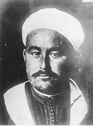
Muhammad bin ‘Abd al-Karīm al-Khaṭābī, better known as Abd el-Krim, was a Moroccan political and military leader and the president of the Republic of the Rif. He and his brother M'Hammad led a large-scale revolt by a coalition of Riffian tribes against the Spanish and French Protectorates of the Rif and the rest of Morocco. His guerrilla tactics, which included the first-ever use of tunneling as a technique of modern warfare, directly influenced Ho Chi Minh, Mao Zedong and Che Guevara. He also became one of the major figures of Arab nationalism, which he actively supported.
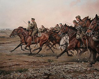
The Battle of Annual was fought on 22 July 1921 at Annual, in northeastern Morocco, between the Spanish Army and Rifian Berbers during the Rif War. The Spanish suffered a major military defeat, which is almost always referred to by the Spanish as the Disaster of Annual which is widely considered to be the worst defeat suffered by the modern Spanish Army.

The Spanish protectorate in Morocco was established on 27 November 1912 by a treaty between France and Spain that converted the Spanish sphere of influence in Morocco into a formal protectorate.

The Rif or Riff, also called Rif Mountains, is a geographic region in northern Morocco. It is bordered on the north by the Mediterranean Sea and Spain and on the west by the Atlantic Ocean, and is the homeland of the Rifians and the Jebala people. This mountainous and fertile area is bordered by Cape Spartel and Tangier to the west, by Berkane and the Moulouya River to the east, by the Mediterranean to the north, and by the Ouergha River to the south. The Rif mountains are separated into the eastern Rif mountains and western Rif mountains.
The Army of Africa, also known as the Moroccan Army Corps, was a field army of the Spanish Army that garrisoned the Spanish protectorate in Morocco from 1912 until Morocco's independence in 1956.
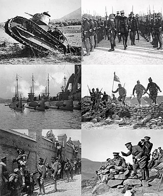
The Rif War was an armed conflict fought from 1921 to 1926 between Spain and the Berber (Amazigh) tribes of the mountainous Rif region of northern Morocco.

Tíjola is a municipality of Almería province, in the autonomous community of Andalusia, Spain. It borders the municipalities of Lúcar, Armuña de Almanzora, Bayarque and Serón.

The Second Melillan campaign was a conflict in 1909 in northern Morocco around Melilla. The fighting involved local Riffians and the Spanish Army.

Melilla Airport is an airport located in Melilla, an exclave of Spain in Africa. The airport is located about 4 km (2.5 mi) southwest of the city, near the border with Morocco. Between 1931 and 1967 Melilla was served by the Tauima Aerodrome, even when Morocco had gained its independence in 1956. This Spanish controlled airport did not open until 1969. It has the capacity to move up to 500,000 passengers and the annual average number of passengers is around 400,000.

Juan Picasso González was a Spanish military man and general who participated in the Rif War with the Spanish Army of Africa in late 19th century and early 20th century. He was a military investigation instructor known for "Expediente Picasso", an investigation report related to the historical defeat of the Spanish Army, some 20,000 soldiers and officers, of which some 8,000 were killed, against the Riffian rebels at the Battle of Annual, on July 1, 1921; known as The disaster of Annual.
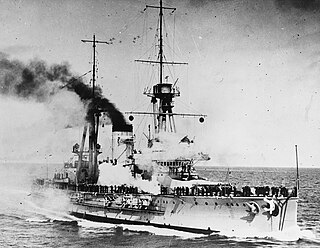
Alfonso XIII was the second of three España-class dreadnought battleships built in the 1910s for the Spanish Navy. Named after King Alfonso XIII of Spain, the ship was not completed until 1915 owing to a shortage of materials that resulted from the start of World War I the previous year. The España class was ordered as part of a naval construction program to rebuild the fleet after the losses of the Spanish–American War; the program began in the context of closer Spanish relations with Britain and France. The ships were armed with a main battery of eight 305 mm (12 in) guns and were intended to support the French Navy in the event of a major European war.

Rusadir was an ancient Punic and Roman town at what is now Melilla, Spain, in northwest Africa. Under the Roman Empire, it was a colony in the province of Mauretania Tingitana.

PauknAir Flight 4101 was a British Aerospace 146 that crashed on a flight from Málaga, Spain, to the Spanish North African exclave of Melilla on 25 September 1998. All 38 passengers and crew on board the aircraft were killed in the accident.

Francisco Gómez-Jordana y Sousa, 1st Count de Jordana, was a Spanish soldier and politician who served as Minister of Foreign Affairs during the rule of Francisco Franco.
Cazaza was a Spanish enclave on the western coast of Cape Three Forks, in what is today Morocco, around 18 km from Melilla. It was here that the exiled Boabdil, last Emir of Granada, landed when he left the Iberian Peninsula in 1492.

The Port of Melilla is a cargo, fishing, and passenger port and marina located in Melilla, a Spanish autonomous city off the coast of North Africa.

José Marina Vega was a Spanish military officer and politician. Leader of the military operations in Melilla during the 1909 Melilla Campaign, he later served as High Commissioner of Spain in Morocco (1913–1915) and as Minister of War.
Emilio Blanco Izaga (1892–1949) was a Spanish military comptroller, ethnographer and architect, who developed his career in the Spanish protectorate in Morocco. He published a number of ethnographic and architectural essays on the Rif region.
Abd el-Kader bel Hach Tieb was a Riffian tribal leader, caïd of the Bni Chiker, in northeastern Morocco.
{{citation}}: CS1 maint: location missing publisher (link). (in Spanish)| International | |
|---|---|
| Geographic | |