Three Islands and Three Islands Reef are part of the Three Islands Group National Park in Far North Queensland, Australia, in the Coral Sea, 1,581 km (982 mi) northwest of Brisbane, about 44 km (27 mi) north-northeast of Cooktown.
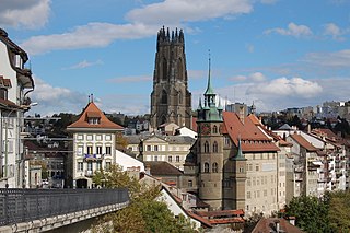
Fribourg or Freiburg is the capital of the Swiss canton of Fribourg and district of La Sarine. Located on both sides of the river Saane/Sarine, on the Swiss Plateau, it is a major economic, administrative and educational centre on the cultural border between German-speaking and French-speaking Switzerland. Its Old City, one of the best-maintained in Switzerland, sits on a small rocky hill above the valley of the Sarine. In 2018, it had a population of 38,365.

The North West Highlands Geopark is a geopark in the Scottish Highlands. Awarded UNESCO geopark status in 2004, it was Scotland's first geopark, featuring some of the oldest rocks in Europe, around 3,000 million years old. The park contains many notable geological features, such as the Moine Thrust Belt and Smoo Cave and covers an area of around 2,000 square kilometres (770 sq mi).

The Vanil Noir is a mountain of the Fribourg Prealps, located on the border between the cantons of Fribourg and Vaud in western Switzerland. Reaching a height of 2,389 metres above sea level, the Vanil Noir is the highest summit of the canton of Fribourg and of the Alpine foothills lying north of the Saane and Simme. It is also the northernmost point in the canton of Vaud above 2,300 metres and the most prominent summit of both cantons.

The Dent de Lys is a mountain in the Bernese Alps, in the canton of Fribourg.

The Dent de Combette is a mountain of the western Bernese Alps, located north of Rougemont in the Swiss canton of Vaud. It lies south of the border with the canton of Fribourg, on the chain culminating at the Dent de Savigny.
The Dent de Savigny is a mountain of the Bernese Alps, located on the border between the Swiss cantons of Vaud and Fribourg. With an elevation of 2,252 metres above sea level, it one of the highest mountains in the canton of Fribourg.
The Schafberg is a mountain peak above Boltigen located on the border between the cantons of Fribourg and Berne, north of Jaun. With a height 2,239 metres above sea level, it is the highest summit on the range lying north of the Jaun Pass. It is also the most isolated mountain in the canton of Fribourg.

The Vanil des Artses is a mountain of the Swiss Prealps, located west of Montbovon in the canton of Fribourg. It is among a crest of peaks extending south of the Dent de Lys to the Cape au Moine (1,941m) on the border between the Cantons of Vaud and Fribourg, which in turn is just north of the Col de Jaman from Rochers de Naye, all lying on the range between Lake Geneva and the valley of Gruyère.

The Dent de Broc is a mountain of the Swiss Prealps, overlooking Broc and the Lake of Gruyère in the canton of Fribourg. It lies on the range north of the Vanil Noir, between the valleys of the Sarine and the Motélon.

The Dent du Chamois is a mountain of the Swiss Prealps, located east of Gruyères in the canton of Fribourg. It lies on the range north of the Vanil Noir, between the valleys of the Sarine and the Motélon.

The Dent du Bourgo is a mountain of the Swiss Prealps, located east of Gruyères in the canton of Fribourg. It lies on the range north of the Vanil Noir, between the valleys of the Sarine and the Motélon.

The Chörblispitz is a mountain of the Swiss Prealps, located north of Jaun in the canton of Fribourg. It lies on the range between the valley of the Breccaschlund and the valley of the Jaunbach.
The Col de Jaman is a mountain pass in the western Swiss Alps, connecting Montreux in the canton of Vaud to Montbovon in the canton of Fribourg. The pass itself, overlooked by the Dent de Jaman, is located within the canton of Vaud, the border with the canton of Fribourg running one kilometre east.

The Cape au Moine is a mountain of the Bernese Alps, located between L'Etivaz and Les Diablerets in the canton of Vaud. It lies east of La Para.

The Pointe de Paray is a mountain of the Swiss Prealps, located on the border between the cantons of Fribourg and Vaud. It has a height of 2,375 metres above sea level, making it both the third highest summit of the Vanil Noir massif and the canton of Fribourg. The mountain lies approximately halfway between the Vanil de l'Ecri and the Gros Perré.
The Vanil de l'Ecri is a mountain of the Swiss Prealps, located on the border between the cantons of Fribourg and Vaud. Reaching a height of 2,376 metres above sea level, it is both the second highest summit of the Vanil Noir massif and the canton of Fribourg. The mountain lies between the Pointe de Paray and the Vanil Noir.
Mont Vully is a hill of the Swiss Plateau, located between Lake Morat and Lake Neuchâtel in the canton of Fribourg, east of the border with the canton of Vaud.

The col de Soladier is a mountain pass in the canton de Vaud, in Switzerland. It is located 1 km west of a ridge linking the Vanil des Artses and the Cape au Moine, and east of Le Molard.

