
The Rochers de Naye is a mountain of the Swiss Alps, overlooking Lake Geneva near Montreux and Villeneuve, in the canton of Vaud. They lie on the range separating the basin of Lake Geneva from the valley of the Sarine, on the watershed between the Rhone and the Rhine. The mountain is partially located in the canton of Fribourg, the border between the two cantons culminating on a lower summit named Grande Chaux de Naye.

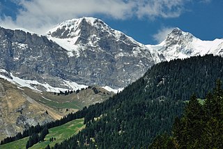
The Vanil Noir is a mountain of the Fribourg Prealps, located on the border between the cantons of Fribourg and Vaud in western Switzerland. Reaching a height of 2,389 metres above sea level, the Vanil Noir is the highest summit of the canton of Fribourg and of the Alpine foothills lying north of the Saane and Simme. It is also the northernmost point in the canton of Vaud above 2,300 metres and the most prominent summit of both cantons.
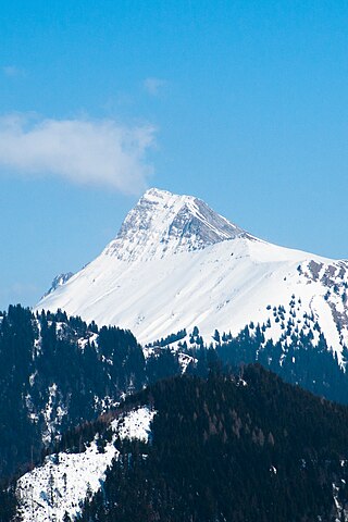
The Dent de Lys is a mountain in the Bernese Alps, in the canton of Fribourg.

The Dent de Brenleire is a mountain of the Fribourg Alps, located south of Charmey in the Swiss canton of Fribourg. It has an elevation of 2,353 metres above sea level and is amongst the highest summits in the canton of Fribourg, after the Vanil Noir, the Vanil de l'Ecri and the Pointe de Paray. It is also the highest mountain entirely within the canton.

The Dent de Combette is a mountain of the western Bernese Alps, located north of Rougemont in the Swiss canton of Vaud. It lies south of the border with the canton of Fribourg, on the chain culminating at the Dent de Savigny.

The Dent de Broc is a mountain of the Swiss Prealps, overlooking Broc and the Lake of Gruyère in the canton of Fribourg. It lies on the range north of the Vanil Noir, between the valleys of the Sarine and the Motélon.

The Dent du Chamois is a mountain of the Swiss Prealps, located east of Gruyères in the canton of Fribourg. It lies on the range north of the Vanil Noir, between the valleys of the Sarine and the Motélon.

The Dent du Bourgo is a mountain of the Swiss Prealps, located east of Gruyères in the canton of Fribourg. It lies on the range north of the Vanil Noir, between the valleys of the Sarine and the Motélon.

The Dent de Folliéran is a mountain of the Fribourg Alps, located south of Charmey in the Swiss canton of Fribourg. It lies on the chain connecting the Vanil Noir to the Dent de Brenleire. It is one of the five summits above 2,300 metres in the canton, the other being the Vanil Noir, the Vanil de L'Ecri, the Pointe de Paray and the Dent de Brenleire.
The Vanil des Cours (1,562) is a mountain of the Swiss Prealps, overlooking the Lake of Gruyère in the canton of Fribourg. It lies in the group culminating at La Berra.

The Vanil d'Arpille is a mountain of the Swiss Prealps, located north of Im Fang in the canton of Fribourg.

The Cape au Moine is a mountain of the Swiss Prealps, located on the border between the cantons of Vaud and Fribourg. It lies north of the Col de Jaman and south of the Col de Soladier, among of a crest of peaks extending roughly north into Fribourg to the Dent de Lys, on the range between Lake Geneva and the valley of Gruyère.
Gros Mont is an alp and mountain pass of the Swiss Alps, located south of Charmey in the canton of Fribourg. The alp lies at the upper end of the Vallée du Gros Mont, just north of a 1,404 metre high pass connecting Charmey with Rougemont. This mountain pass, on the watershed between the Jogne and the upper Sarine, is the lowest point between the massifs of the Vanil Noir and the Gastlosen.

The Cape au Moine is a mountain of the Bernese Alps, located between L'Etivaz and Les Diablerets in the canton of Vaud. It lies east of La Para.

The Pointe de Paray is a mountain of the Swiss Prealps, located on the border between the cantons of Fribourg and Vaud. It has a height of 2,375 metres above sea level, making it both the third highest summit of the Vanil Noir massif and the canton of Fribourg. The mountain lies approximately halfway between the Vanil de l'Ecri and the Gros Perré.
The Vanil de l'Ecri is a mountain of the Swiss Prealps, located on the border between the cantons of Fribourg and Vaud. Reaching a height of 2,376 metres above sea level, it is both the second highest summit of the Vanil Noir massif and the canton of Fribourg. The mountain lies between the Pointe de Paray and the Vanil Noir.

The Niremont is a mountain of the Swiss Prealps, in the canton of Fribourg. Due to its rounded shape, it has 2 sub-summits : The Gros Niremont and the Petit Niremont.

Corbetta is a mountain of the Swiss Prealps, in the canton of Fribourg.

The col de Soladier is a mountain pass in the canton de Vaud, in Switzerland. It is located 1 km west of a ridge linking the Vanil des Artses and the Cape au Moine, and east of Le Molard.

