Capitola, Florida

Last updated
Capitola, Florida
USA Florida location map.svg
Red pog.svg
Capitola
Usa edcp location map.svg
Red pog.svg
Capitola
Coordinates: Coordinates: 30°27′04″N84°05′17″W / 30.45111°N 84.08806°W / 30.45111; -84.08806
Country Flag of the United States.svg  United States
State Flag of Florida.svg  Florida
County   Leon
ZIP code

Capitola is a small unincorporated community in eastern Leon County, Florida, United States, located at County Road 1540 (Capitola Road) and County Road 1541 (Baum Road).

Contents

History

Evergreen Hills Plantation, a large cotton plantation, occupied the land that is now or extremely close to Capitola. From 1908 through the 1940s Capitola was served by the Florida Central Railroad. Capitola was originally called the town of Mays. Some of the first families that moved into Capitola were the Duprees, Boyds, and the Upchurches.

On March 7, 2008 a confirmed EF1 tornado struck the community with winds estimated at 105 miles per hour. Six to eight houses were damaged near the intersection of Capitola and Whitehouse roads. One minor injury was reported. [1]

Today

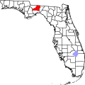
The small town of Capitola, with just a few dozen residents in eastern Leon County, is often overshadowed by its neighbor, Chaires, to the southwest. Fire and rescue services are provided to the community by the Chaires-Capitola Volunteer Fire Department.

The heart of town is marked by the Capitola Joy Mart, a small grocery / convenience store. The area is also home to the Capitola Baptist Church which was established in 1926 and The Capitola Cemetery, where the towns namesake is buried, Capitola DuPree. The Cemetery is located off of Cap Tram road in a very wooded area. Capitola is known for its beautiful southern landscapes with several farms inside the heart of it.

Capitola is also home to the Chaires-Capitola Volunteer Fire Department. [2]

Political

Capitola Governmental Representation
PositionNameParty

County Commission At-LargeCliff ThaellDemocrat
County Commission At-LargeEd DePuyRepublican
CommissionerBob RackleffDemocrat
U.S. House Ander Crenshaw Republican
Florida House Loranne Ausley Democrat

Note: DePuy was appointed by Governor Jeb Bush in 2004.

Related Research Articles

Leon County, Florida County in Florida, United States

Leon County is a county located in the Panhandle of the U.S. state of Florida. It was named after the Spanish explorer Juan Ponce de León. As of 2017 Census estimates, the population was 290,292.

Algonquin, Illinois Village in Illinois, United States

Algonquin is a village in McHenry and Kane counties, Illinois, in the United States. It is a suburb of Chicago, located approximately 40 miles (64 km) northwest of the Loop. As of the 2010 census the village's population was 30,046, and as of 2017 the estimated population was 31,017.

Dover, New York Town in New York, United States

Dover is a town in Dutchess County, New York, United States. The population was 8,699 at the 2010 census. The town was named after Dover in England, the home town of an early settler.

Mount Pleasant, South Carolina Suburban town in Charleston, South Carolina, United States

Mount Pleasant is a large suburban town in Charleston County, South Carolina, United States. It is the fourth largest municipality and largest town in South Carolina, and for several years was one of the state's fastest-growing areas, doubling in population between 1990 and 2000. The population was 67,843 at the 2010 census,. The estimated population in 2018 was 89,338. At the foot of the Arthur Ravenel Bridge is Patriots Point, a naval and maritime museum, home to the World War II aircraft carrier USS Yorktown, which is now a museum ship. The Ravenel Bridge, an eight-lane highway that was completed in 2005, spans the Cooper River and links Mount Pleasant with the city of Charleston.

Vineland, Florida Unincorporated community in Florida, United States

Vineland is an unincorporated community in southwest Orange County, Florida, United States, located just north of Interstate 4 along State Road 535 and continues along County Road 435, which is South Apopka Vineland Road. The name is no longer often used since the more well-known City of Lake Buena Vista lies just to the south and west. Orange County officially calls the area Buena Vista North or Orange Center, its original name. Mailing addresses for residents in the area are typically Orlando, Florida except many businesses in the area use Lake Buena Vista as their address. The area is most famous due to the name appearing on a large number of major Orange County roads, including Apopka-Vineland Road, Winter Garden-Vineland Road, Kissimmee-Vineland Road and Taft-Vineland Road. There was also a small town which was abandoned in the 1960s called Vineland. An ACL Railway Depot, Housing, a schoolhouse, a church, the Vineland Cemetery, and many more community facilities were a part of the original town. These roads begin/terminate in the area known as Vineland and Lake Buena Vista, Florida.

Miccosukee, Florida Unincorporated community in Florida, United States

Miccosukee is a former small unincorporated community in northeastern Leon County, Florida, United States. It is located at the junction of County Road 59 and County Road 151. Miccosukee was a major center of the Miccosukee tribe, one of the tribes of the developing Seminole nation, during the 18th century.

Lake Iamonia lake of the United States of America

Lake Iamonia is a large, subtropical prairie lake in northern Leon County, Florida, United States, created during the Pleistocene epoch.

Evergreen Hills Plantation human settlement in United States of America

Evergreen Hills Plantation was a large cotton plantation of 6700 acres (27 km²) located in eastern Leon County, Florida, United States established by Green H. Chaires.

Southwood Plantation human settlement in United States of America

Southwood Plantation was a large cotton plantation of 5,000 acres (20 km2) located in southern Leon County, Florida, United States and owned by George Taliafero Ward.

R. G. Shepard Plantation human settlement in United States of America

The R. G. Shepard Plantation was a small cotton plantation of 1,400 acres (570 ha) located in south central Leon County, Florida, United States established by R.G. Shepard.

Chaires, Florida human settlement in Florida, United States of America

Chaires is an unincorporated community located just east of Tallahassee in Leon County, Florida, United States. It is located near the intersection of Chaires Cross Road and Capitola Road, northeast of Lake Lafayette and the Edwards Wildlife Area.

Waverly Plantation (Leon County, Florida) human settlement in United States of America

Waverly Plantation was a large cotton plantation of unknown size, located in southern Leon County, Florida, United States, owned by George Taliaferro Ward.

Magnolia, Florida Former town in the United States

Magnolia, Florida was a thriving river port town in southern Wakulla County, Florida, established in the 1820s and is classified as an "extinct city" by the State Library and Archives of Florida.↵All that remains of the city is the cemetery, the last known burial was in 1859. The cemetery is on land now owned by the St. Joe Paper Company. The town was located near the small city of St. Marks, Florida.

The history of Tallahassee, like the history of Leon County, begins with the Native American population and its interaction with British and Spanish colonists as well as colonial Americans and fugitive slaves, as the Florida Territory moved toward statehood. Growing numbers of cotton plantations increased the settlement's population greatly. It became a city and capital in 1821.

Poplar Springs is a small unincorporated community in southwestern Surry County, North Carolina, on Poplar Springs Road between the town of Elkin and the community of Mulberry. Prominent landmarks include Poplar Springs Baptist Church and cemetery. The community is serviced by State Road Volunteer Fire Department, founded in 1960. Also located in the area is Cedar Brook Country Club popular for golf, tennis, and swimming for area citizens. Businesses in the area include: Poplar Springs Grocery and Service, Tracy's Garage, Elk Electric Motors, L & A Emergency Equipment, Inc., Watson Metals, and Pine Log Company.

Rosharon, Texas Census-designated place in Texas, United States

Rosharon, also known as "Buttermilk Station," is an unincorporated community and census-designated place (CDP) in Brazoria County, Texas, United States, at the intersection of Farm to Market Road 521 and Farm to Market Road 1462. As of the 2010 census, it had a population of 1,152.

Chaires-Capitola Volunteer Fire Department

The Chaires-Capitola Volunteer Fire Department is an all volunteer fire department located in eastern Leon County, Florida. The department provides service for the communities of Chaires and Capitola, as well as 76 square miles (200 km2) of unincorporated Leon County east of Tallahassee which includes over 7,600 homes. The department is under the administrative oversight and medical direction of Leon County Emergency Medical Services and contracts with the Tallahassee Fire Department for mutual-aid to emergencies outside of the city limits.

Sandy Point, Texas City in Texas, United States

Sandy Point is a city on Farm to Market Road 521 (FM 521) in north central Brazoria County, Texas, United States. The small community is located near a state prison. In the 19th century, the settlement served nearby sugar cane and cotton plantations. Sandy Point's post office, school and railroad have disappeared, but there were two churches in the community in December 2013.

Marion Station, Maryland Unincorporated community in Maryland, United States

Marion Station, also known as Marion, is an unincorporated community in Somerset County, Maryland, United States. It is located at the northern intersection of Maryland Route 413 and Maryland Route 667. After the arrival of the Pennsylvania Railroad arm known as the "Eastern Shore Railroad" toward Crisfield in 1866, Marion was locally hailed as the "strawberry capital of the world". After the trains stopped coming it has gone into decline, with some sources even hailing it as a ghost town.

Loma Chiquita, California Populated Place in California, United States

Loma Chiquita is an unincorporated rural area along the ridge leading to Loma Chiquita summit in southwest Santa Clara County, California. The area covers the associated ridgeline and hillsides, from the eastern base of Loma Prieta, towards the west near the intersection with upper Little Uvas Road. The northern part faces the Mountain Home area, and the southern part overlaps with Uvas Canyon.

References

  1. National Weather Service Storm Report
  2. "About Us". Chaires-Capitola Volunteer Fire Department. Retrieved 17 April 2015.