
Snowdonia, or Eryri, is a mountainous region and national park in North Wales. It contains all 15 mountains in Wales over 3000 feet high, including the country's highest, Snowdon, which is 1,085 metres (3,560 ft) tall. These peaks are all part of the Snowdon, Glyderau, and Carneddau ranges in the north of the region. The shorter Moelwynion and Moel Hebog ranges lie immediately to the south.

The history of what is now Wales begins with evidence of a Neanderthal presence from at least 230,000 years ago, while Homo sapiens arrived by about 31,000 BC. However, continuous habitation by modern humans dates from the period after the end of the last ice age around 9000 BC, and Wales has many remains from the Mesolithic, Neolithic, and Bronze Age. During the Iron Age the region, like all of Britain south of the Firth of Forth, the culture had become Celtic, with a common Brittonic language. The Romans, who began their conquest of Britain in AD 43, first campaigned in what is now northeast Wales in 48 against the Deceangli, and gained total control of the region with their defeat of the Ordovices in 79. The Romans departed from Britain in the 5th century, opening the door for the Anglo-Saxon settlement. Thereafter, the culture began to splinter into a number of kingdoms. The Welsh people formed with English encroachment that effectively separated them from the other surviving Brittonic-speaking peoples in the early middle ages.

Powys is a county and preserved county in Wales. It borders Gwynedd, Denbighshire, and Wrexham to the north; the English ceremonial counties of Shropshire and Herefordshire to the east; Monmouthshire, Blaenau Gwent, Merthyr Tydfil, Caerphilly, Rhondda Cynon Taf, and Neath Port Talbot to the south; and Carmarthenshire and Ceredigion to the west. The largest settlement is Newtown, and the administrative centre is Llandrindod Wells.

Dinas Emrys is a rocky and wooded hillock near Beddgelert in Gwynedd, north-west Wales. Rising some 76 m (250 ft) above the floor of the Glaslyn river valley, it overlooks the southern end of Llyn Dinas in Snowdonia.

A hillfort is a type of fortified refuge or defended settlement located to exploit a rise in elevation for defensive advantage. They are typically European and of the Bronze Age or Iron Age. Some were used in the post-Roman period. The fortification usually follows the contours of a hill and consists of one or more lines of earthworks or stone ramparts, with stockades or defensive walls, and external ditches. If enemies were approaching, the civilians would spot them from a distance.

Gruffudd ap Cynan, sometimes written as Gruffydd ap Cynan, was King of Gwynedd from 1081 until his death in 1137. In the course of a long and eventful life, he became a key figure in Welsh resistance to Norman rule.

The Berwyn range is an isolated and sparsely populated area of moorland in the northeast of Wales, roughly bounded by Llangollen in the northeast, Corwen in the northwest, Bala in the southwest, and Oswestry in the southeast.

The Kingdom of Gwynedd was a Welsh kingdom and a Roman Empire successor state that emerged in sub-Roman Britain in the 5th century during the Anglo-Saxon settlement of Britain.

Aberffraw is a village and community on the south west coast of the Isle of Anglesey in Wales. The village is 9 miles from the island's county town, Llangefni, and is located on the west bank of the Afon Ffraw. The community includes Soar and Dothan. Located near the A4080 and the nearest rail station is Bodorgan.

The Glyderau are a mountain group in Snowdonia, North Wales. The name derives from the highest peaks in the range, Glyder Fawr and Glyder Fach. According to Sir Ifor Williams, the word "Glyder" derives from the Welsh word "Cludair", meaning a heap of stones.

Yr Eifl, sometimes called the Rivals in English, is a group of hills on the north coast of the Llŷn Peninsula in Gwynedd, Wales.

Dolbadarn Castle is a fortification built by the Welsh prince Llywelyn the Great during the early 13th century, at the base of the Llanberis Pass, in northern Wales. The castle was important both militarily and as a symbol of Llywelyn's power and authority. The castle features a large stone keep, which historian Richard Avent considers "the finest surviving example of a Welsh round tower". In 1284 Dolbadarn was taken by Edward I, who removed some of its timbers to build his new castle at Caernarfon. The castle was used as a manor house for some years, before falling into ruin. In the 18th and 19th centuries, it was a popular destination for painters interested in Sublime and Picturesque landscapes. It is now owned by Cadw and managed as a tourist attraction, and is protected as a grade I listed building.

Pen Dinas is a large hill in Penparcau, on the coast of Ceredigion, Wales, upon which an extensive Iron Age, Celtic hillfort is situated. The site can easily be reached on foot from Aberystwyth town centre and is accessible via a series of well marked trails. Boasting a commanding position at the confluence of the River Ystwyth and Afon Rheidol, it has been described as "the pre-eminent hillfort on the Cardigan Bay coast".

Rhos is a region to the east of the River Conwy in North Wales. It started as a minor kingdom then became a medieval cantref, and was usually part of the Kingdom of Gwynedd.
The Llŷn Peninsula extends 30 miles (50 km) into the Irish Sea from North West Wales, south west of the Isle of Anglesey. It is part of the historic county of Caernarfonshire, and historic region and local authority area of Gwynedd. Much of the eastern part of the peninsula, around Criccieth, may be regarded as part of Eifionydd rather than Llŷn, although the boundary is somewhat vague. The area of Llŷn is about 400 km2 (150 sq mi), and its population is at least 20,000.

The Isle of Anglesey is a county off the north-west coast of Wales. It is named after the island of Anglesey, which makes up 94% of its area, but also includes Holy Island and some islets and skerries. The county borders Gwynedd across the Menai Strait to the southeast, and is otherwise surrounded by the Irish Sea. Holyhead is the largest town, and the administrative centre is Llangefni. The county is part of the preserved county of Gwynedd.

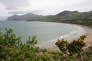
Sarn Meyllteyrn is a village and former civil parish in the Welsh county of Gwynedd. It is in the west of the Llŷn Peninsula, 8.4 miles (13.5 km) west of Pwllheli and 24.3 miles (39.2 km) south-west of Caernarfon. The village is often referred to simply as Sarn. The parish was abolished in 1934 and divided between the communities of Botwnnog and Tudweiliog.
Gaer Penrhôs, in Ceredigion, Wales, was a ringwork castle at the summit of a steep hill near the village of Llanrhystud; now all that remains are the outlines of its ringworks. Through the years it has variously been referred to as Llanrhystud Castle and Castell Cadwaladr and has likely been the site of more than one structure.

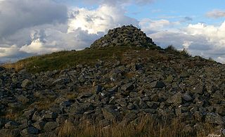
Garn Boduan is an Iron Age hillfort and hill near Nefyn, on the Llŷn Peninsula in Wales.
Caer Drewyn is an early Iron Age hillfort to the north of the town of Corwen, Denbighshire. It has a large stone rampart with entrances on the west and north sides; there is a guard chamber within the north-east entrance, and it has a deep defensive ditch.


