The Seven Summits are the highest mountains of each of the seven traditional continents. Climbing to the summit of all of them was first done on 30 April 1985 by Richard Bass. Once considered a mountaineering challenge, in January 2023, Climbing said "Today, the Seven Summits are a relatively common—almost cliché—tour of each continent's highest peak", and that the real challenge was the Explorer's Grand Slam, the Seven Summits with the North and South poles.
Patrick Allan Morrow, is a Canadian photographer and mountain climber. In 1986 he was the first person to climb the Seven Summits in the Carstensz-Version.

Puncak Trikora, until 1963 Wilhelmina Peak, is a 4,730 or 4,750-metre-high (15,584 ft) mountain in the Highland Papua province of Indonesia on New Guinea. It lies in the eastern part of the Sudirman (Nassau) Range of the Maoke Mountains.
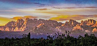
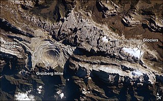
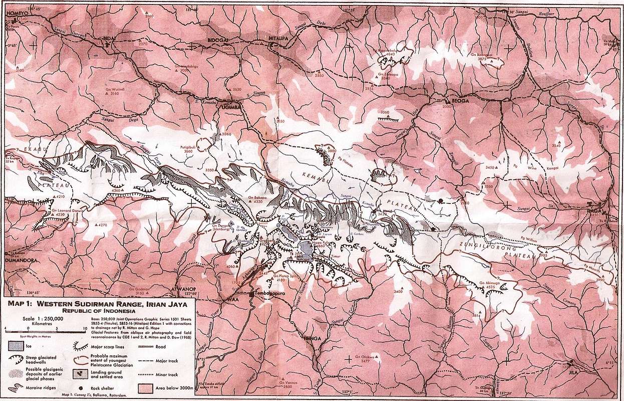
The Sudirman Range, also known as the Snow Mountains, Dugunduguoo, or Nassau Range is a mountain range in Central Papua province, Indonesia. It is named after the first armed forces commander-in-chief and Indonesian national hero Sudirman. It comprises a western portion of the Maoke Mountains. The highest peak in Oceania and Australasia, Puncak Jaya, is located here, as well as the large Grasberg copper and gold mine, operated by the Freeport company based out of the United States. Other peaks of the Sudirman Range are:

The Seven Second Summits are the second-highest mountains of each of the seven continents. All of these mountain peaks are separate peaks rather than a sub-peak of the continents' high point. The Seven Second Summits are considered a harder challenge than the traditional Seven Summits.
The glacier rat is a species of rodent in the family Muridae. It is endemic to the New Guinea Highlands near Puncak Trikora and Puncak Jaya, West Papua, Indonesia. Its altitudinal range is 3,225–4,500 m (10,581–14,764 ft) above sea level.

Puncak Jaya Regency is one of the regencies (kabupaten) in the Indonesian province of Central Papua. It is an inland highland regency, lying directly east of Paniai Regency and west of Jayawijaya Regency and Tolikara Regency. As of 2004, it was reported that these four regencies had a population that is 93–97% ethnic Papua; however this included areas which have subsequently been formed into new regencies.
Tsinga or Singa is a village in Indonesia located in Western New Guinea, in the kabupaten of Mimika Regency.

The Carstensz expedition was made in 1936 by Anton Colijn, Jean Jacques Dozy and Frits Wissel. They left on October 29, 1936, from Aika, a town on the southern coast of Dutch New Guinea and returned on December 24. The aim of the expedition was reached by climbing the highest peak of the Carstenzgebergte, which at the time was the snow-covered peak of Ngga Pulu. Since 1936, massive snow melt has caused the nearby rocky spires of Carstensz Pyramid, which the expedition was unable to climb, to become the highest summit.

Puncak Jaya, or Carstensz Pyramid on the island of New Guinea, with an elevation of 4,884 m (16,024 ft), is the highest mountain peak of an island on Earth. The mountain is located in the Sudirman Range of the highlands of Mimika Regency, Central Papua, Indonesia.
The West Northwall Firn was a glacial body on Mount Carstensz in the Sudirman Range on the island of New Guinea in Central Papua province, Indonesia. The glacier was situated at an elevation of approximately 4,600 metres (15,100 ft) to 4,750 metres (15,580 ft), centered a little over 3 kilometres (1.9 mi) northwest of Ngga Pulu and 5 kilometres (3.1 mi) of Puncak Jaya, the highest peak of Oceania.
The East Northwall Firn was a glacier on Mount Carstensz in the Sudirman Range on the island of New Guinea in Central Papua province, Indonesia. Situated at an elevation of approximately 4,750 metres (15,580 ft) 2.5 kilometres (1.6 mi) NNW of Puncak Jaya, the highest summit in Oceania. It broke up in three patches in or before 2017.
The Carstensz Glacier is near the peak of Puncak Jaya which is a mountain in the Sudirman Range of the island of New Guinea, territorially the eastern highlands of Central Papua, Indonesia. The glacier is situated at an elevation of approximately 4,600 metres (15,100 ft) and is 1.5 kilometres (0.93 mi) east of the summit tower of Puncak Jaya. In 2002 the Carstensz Glacier was 1.4 kilometres (0.87 mi) in length and .60 kilometres (0.37 mi) wide.

Ngga Pulu is a summit on the north rim of Mount Carstensz in the western part of the island of New Guinea rising 4,862 metres (15,951 ft). Trigonometric measurements showed that Ngga Pulu was the highest mountain of New Guinea and also the highest summit of the Australia-New Guinea continent. The elevation of Ngga Pulu in 1936 was about 4,907 m (16,099 ft), and it was the highest and most prominent peak between the Himalaya and the Andes. However, due to glacial melting, Ngga Pulu lost a lot of elevation in the 20th century, being surpassed by Puncak Jaya.
Ngga Pilimsit is a mountain located in the Indonesian province of Papua, in the Maoke Mountains. It rises 4,717 meters (15,476 ft). It is a little over thirteen miles west-northwest of Puncak Jaya, the highest peak of Oceania and Indonesia. The nearest peaks are Carstensz Pyramid, Wataikwa, Ubia, Venusberg, Otakwa, and Papua Peak 4061. Dependent on the definition used for an independent mountain, the peak ranks as the fourth to seventh highest mountain on New Guinea and in Indonesia.

The Seven Third Summits are the third-highest mountains of each of the seven continents. All of these mountain peaks are separate peaks rather than a sub-peak of the continents' high point. Christian Stangl from Austria claims to be the first person to reach the summit of all seven third summit mountains after climbing Puncak Mandala and Puncak Trikora. He did this as a part of his "Triple Seven Summits" project. Because of glacial melting and the disagreement over exactly which three peaks are the tallest in the Australian continent, Stangl also climbed several additional candidate peaks including Sumantri and Ngga Pulu.

The Eight Summits is the collective name for the eight highest mountain peaks on each of the seven continents. It is an alternative name for the "Seven Summits" due to different ways in naming the highest mountain on the continent of Australia.

Central Papua, officially the Central Papua Province is an Indonesian province located in the central region of Western New Guinea. It was formally established on 11 November 2022 from the former eight western regencies of the province of Papua. It covers an area of 61,072.92 km2 and had an officially estimated population of 1,430,951 in mid 2022. It is bordered by the Indonesian provinces of West Papua to the west, province of Papua to the north, and by Highland Papua and South Papua to the east. The designated administrative capital is located in Nabire Regency.

