Sousel is a municipality in the District of Portalegre in Portugal. The population in 2011 was 5,074, in an area of 279.32 km2.

Jacareí is a city in the state of São Paulo, Brazil. The population is 235,416 in an area of 464.27 km2. The city is known as "Capital of Beer" by the daily output of its factories, considered the biggest in Latin America. The economic activity is mainly based on industrial production. The industries produce mainly paper, chemicals, glass, wire, and rubber.

Aguaí is a Brazilian municipality located in the eastern part of the state of São Paulo. The population is 36,648 in an area of 475 square kilometres (183 sq mi). The settlement Cascavel was established in 1887 near a railway station. In 1944, when it was separated from São João da Boa Vista, it became an independent municipality with the name Aguaí.

São Pedro is a municipality in the state of São Paulo in Brazil. The population is of 35,980 (2020) in an area of 611.278 km2 (236.02 sq mi).

Graciosa Island is referred to as the White Island, the northernmost of the Central Group of islands in the Azores. The ovular Portuguese island has an area of 60.65 square kilometres, a length of 10 kilometres and a width of 7 kilometres. It is a volcanic island, dominated by a 1.6-kilometre-wide (1.0-mile) central caldera located in the southeast.

Santa Branca is a municipality in the state of São Paulo in Brazil. It is part of the Metropolitan Region of Vale do Paraíba e Litoral Norte. The population is 14,857 in an area of 272.24 km2. The elevation is 648 m. The Rodovia Governador Carvalho Pinto (SP-070) passes north of Santa Branca.

Nelas is a municipality located in the Centro Region of continental Portugal. The population in 2011 was 14,037, in an area of 125.71 km².
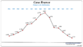
Casa Branca is a municipality in the state of São Paulo in Brazil. The population is 30,520 in an area of 864 km². It was founded in 1841. Its nickname is "the Jabuticaba capital"

Pedra Branca do Amapari, also known simply as Amapari, is a municipality located in the midwest of the state of Amapá in Brazil. Its population is 17,067 and its area is 9,495 square kilometres (3,666 sq mi). The municipality has a population density of 1.13/km2, and the population remains even divided between rural and village areas.
Areia Branca is a municipality located in the Brazilian state of Sergipe. Its population was 18,686 (2020) and it covers 148.13 km2 (57.19 sq mi). Areia Branca has a population density of 120 inhabitants per square kilometer. It is located 36 km (22 mi) from the state capital of Sergipe, Aracaju. The municipality contains part of the Serra de Itabaiana National Park.

Laranjeiras is a municipality located in the Brazilian state of Sergipe. Its population was 30,080 (2020) and covers 162.27 km2 (62.65 sq mi). Laranjeiras has a population density of 180 inhabitants per square kilometer. Laranjeiras is located 19 km (12 mi) from the state capital of Sergipe, Aracaju. It borders the municipalities of Riachuelo, Areia Branca, Nossa Senhora do Socorro, São Cristóvão, Maruim, and Santo Amaro das Brotas, all within the state of Sergipe. The municipality contains part of the Serra de Itabaiana National Park.
Branca is a given name and surname.
Louriçal is a Portuguese freguesia of Pombal municipality. The population in 2011 was 4,645, in an area of 47.66 km2.
The Portuguese postal code is formed by four digits, a hyphen, then three digits, followed by a postal location of up to 25 characters in capitals.
Avenida Marconi 4C 1000-205 Lisboa

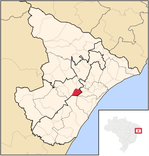
Jeremoabo is a municipality in the state of Bahia in the North-East region of Brazil.
Casa Branca or Casabranca may refer to:
Ribeira dos Calhaus is a settlement in the western part of the island of São Nicolau, Cape Verde. It is part of the municipality of Tarrafal de São Nicolau. It is situated in a valley northwest of Monte Gordo, 3 km southeast of Praia Branca and 7 km north of Tarrafal de São Nicolau.
Xoxocotla is a municipality in the Mexican state of Veracruz, located 103 kilometres (64 mi) south of the state capital Xalapa.

Zacualpan is a municipality in the Mexican state of Veracruz, located 179 kilometres (111 mi) northwest of the state capital of Xalapa and 56 kilometres (35 mi) northeast of the city of Pachuca, Hidalgo.
Zaragoza is a municipality in the Mexican state of Veracruz, located 297 kilometres (185 mi) southeast of the state capital of Xalapa and 10 kilometres (6.2 mi) southwest of the city of Minatitlán.