
Puebla de Zaragoza, formally Heroica Puebla de Zaragoza, formerly Puebla de los Ángeles during colonial times, or known simply as Puebla, is the seat of Puebla Municipality. It is the capital and largest city of the state of Puebla, and the fourth largest city in Mexico, after Mexico City, Monterrey, and Guadalajara. A viceregal era planned city, it is located in the southern part of Central Mexico on the main route between Mexico City and Mexico's main Atlantic port, Veracruz—about 100 km (62 mi) east southeast of Mexico City and about 220 km (140 mi) west of Veracruz.

Coyoacán is a borough in Mexico City. The former village is now the borough's "historic center". The name comes from Nahuatl and most likely means "place of coyotes", when the Aztecs named a pre-Hispanic village on the southern shore of Lake Texcoco dominated by the Tepanec people. Against Aztec domination, these people allied with the Spanish, who used the area as a headquarters during the Spanish conquest of the Aztec Empire and made it the first capital of New Spain between 1521 and 1523.
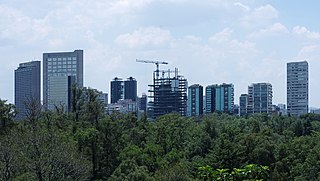
Miguel Hidalgo is a borough (alcaldía) in western Mexico City, it encompasses the historic areas of Tacuba, Chapultepec and Tacubaya along with a number of notable neighborhoods such as Polanco and Lomas de Chapultepec. With landmarks such as Chapultepec Park and the Museo Nacional de Antropología, it is the second most visited borough in Mexico City after Cuauhtémoc where the historic center of Mexico City is located. Tacubaya and Tacuba both have long histories as independent settlements and were designated as “Barrios Mágicos” by the city for tourism purposes.
Talavera de la Reina is a city and municipality of Spain, part of the autonomous community of Castile–La Mancha. Its population of 83,303 makes it the second most populated municipality of the province of Toledo and the fourth largest in the region.

San Ángel is a colonia or neighborhood of Mexico City, located in the southwest in Álvaro Obregón borough. Historically, it was a rural community, called Tenanitla in the pre-Hispanic period. Its current name is derived from the El Carmen monastery school called San Ángel Mártir. San Ángel remained a rural community, centered on the monastery until the 19th and 20th centuries, when the monastery was closed and when the area joined urban sprawl of Mexico City. However, the area still contains many of its former historic buildings and El Carmen is one of the most visited museums in the city. It is also home to an annual flower fair called the Feria de las Flores, held since 1856.

Colonia Roma, also called La Roma or simply, Roma, is a district located in the Cuauhtémoc borough of Mexico City just west of the city's historic center. The area comprises two colonias: Roma Norte and Roma Sur, divided by Coahuila street.

The historic center of Mexico City, also known as the Centro or Centro Histórico, is the central neighborhood in Mexico City, Mexico, focused on the Zócalo and extending in all directions for a number of blocks, with its farthest extent being west to the Alameda Central. The Zocalo is the largest plaza in Latin America. It can hold up to nearly 100,000 people.

Talavera pottery is a Mexican and Spanish pottery tradition from Talavera de la Reina, in Spain. In 2019, it was included in UNESCO's Representative List of the Intangible Cultural Heritage of Humanity.
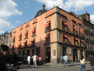
The Mexico City administrative buildings are two buildings on the south side of the Zócalo in Mexico City divided by the avenue Avenida 20 de Noviembre. They house offices of the governing authority of Mexico City. The building to the west of 20 de Noviembre is the older one and has been the site of city administration since the Conquest. The one to the east is newer, built in the 20th century.
The House of the First Printing Press in the Americas at the corner of Moneda and Licenciado Primo Verdad streets in Mexico City was the home of the first printing press/print shop in the New World. The printer Juan Pablos oversaw the printing of at least 35 books at this print shop between 1539, the date of the first book printed in the Americas, and his death in 1560.
The Convent of Nuestra Señora de La Merced was a Roman Catholic colonial religious complex in present-day Historic center of Mexico City, that was destroyed to give more space to future buildings. The cloister is all that is left of a monastery complex built in the late 16th and early 17th century by the Mercedarian order. It is located on Uruguay and Talavera Streets in the historic downtown of Mexico City. The complex lent its name to the area around it, La Merced, which in turn, inspired the name of the metro station and the well-known neighborhood Market.

The Caricature Museum is located in an 18th-century Baroque building in the historic center of Mexico City. It was opened in 1987 to preserve and promote the history of Mexican cartooning, done for both political and entertainment purposes. The historic building it occupies was originally the home of Cristo College, a royal college established in 1612.

Francisco Antonio de Guerrero y Torres was a Mexican Baroque architect who was prominent in Mexico City, the capital of New Spain. He built several palaces and buildings at the basilica devoted to Our Lady of Guadalupe.

The Palacio de la Autonomía is a museum and site where the Universidad Nacional Autónoma de México gained autonomy from direct government control in 1929. The building is from the late 19th century, and located on the corner of Licenciado de Verdad and Rep de Guatemala streets, north of Santa Teresa la Antigua and east of Templo Mayor. The site has a 500-year history, starting from part of lands granted by Hernán Cortés. The current building was constructed by the administration of President Porfirio Díaz, but it was ceded to the university in 1910. Since that time, the building has had a number of uses, including housing a dental school and a preparatory school. Today it houses the Museo de la Autonomía Universitaria.

The Universidad Autónoma de la Ciudad de México (UACM) is a public university from México City founded in 2001. Before, the Federal District was the only federal entity without a state university.

La Merced is a barrio or a neighborhood of Mexico City defined by its socioeconomics and history rather than by an official designation. It extends over the southeast of the historic center of Mexico City and is one of the oldest sections of the city, established over 700 years ago by the Mexica as part of the founding of Tenochtitlan. Over its history the area was associated with commerce, first as a major docking area for boats bringing goods to Tenochtitlan/Mexico City on Lake Texcoco, later via canals as the lake was slowly drained. In the latter 19th century, the La Merced market was established in the area replacing the massive La Merced monastery which was almost completely destroyed in the 1860s. This market was established to centralize the marketing of foodstuffs for the city on one area. The first La Merced market was built in 1890 and then replaced by the current building in 1957, one of the largest traditional Mexican markets in Mexico City. In the 1980s, the wholesale function of this market was taken over by the newly constructed Centro de Abasto in the south of the city, with the barrio then going into economic and social decline, with the area having problems with poverty, prostitution and population loss. Although there have been efforts to revitalize the area and the La Merced market remains important.

Mixcoac is an area of southern Mexico City which used to be a separate town and municipality within the Mexican Federal District until it was made part of Mexico City proper in 1928.
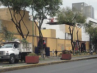
The Ciudadela Market is a traditional style Mexican market which specializes in the sale of Mexican handcrafts and folk art, located in the southwest corner of the historic center of Mexico City. The market is the first of its kind in the country, established just before the 1968 Summer Olympics to promote this aspect of Mexico's cultural heritage. It is home to over 350 vendors, mostly small operators selling to Mexican and foreign tourists.

Handcrafts and folk art in Mexico City is a microcosm of handcraft production in most of the rest of country. One reason for this is that the city has attracted migration from other parts of Mexico, bringing these crafts. The most important handcraft in the city is the working of a hard paper mache called cartonería, used to make piñatas and other items related to various annual celebrations. It is also used to make fantastic creatures called alebrijes, which originated here in the 20th century. While there are handcrafts made in the city, the capital is better known for selling and promoting crafts from other parts of the country, both fine, very traditional wares and inexpensive curio types, in outlets from fine shops to street markets.
