
Santo Domingo, once known as Santo Domingo de Guzmán and Ciudad Trujillo, is the capital and largest city of the Dominican Republic and the largest metropolitan area in the Caribbean by population. As of 2022, the Distrito Nacional had a population of 1,484,789, while the total population is 2,995,211 when including the metropolitan area. The city is coterminous with the boundaries of the Distrito Nacional, itself bordered on three sides by Santo Domingo Province.

The Casa Rosada is the office of the president of Argentina. The palatial mansion is known officially as Casa de Gobierno. Normally, the president lives at the Quinta de Olivos, the official residence of the president of Argentina, which is located in Olivos, Greater Buenos Aires. The characteristic color of the Casa Rosada is baby pink, and is considered one of the most emblematic buildings in Buenos Aires. The building also houses a museum, which contains objects relating to former presidents of Argentina. It has been declared a National Historic Monument of Argentina.

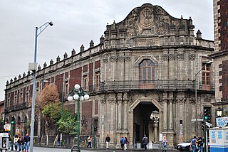
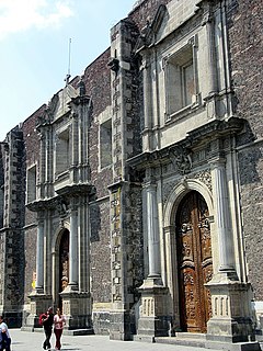
The National Palace is the seat of the federal executive in Mexico. Since 2018 it has also served as the official residence for the President of Mexico. It is located on Mexico City's main square, the Plaza de la Constitución. This site has been a palace for the ruling class of Mexico since the Aztec Empire, and much of the current palace's building materials are from the original one that belonged to the 16th-century leader Moctezuma II.

The historic center of Mexico City, also known as the Centro or Centro Histórico, is the central neighborhood in Mexico City, Mexico, focused on Zócalo or main plaza and extending in all directions for a number of blocks, with its farthest extent being west to the Alameda Central. The Zocalo is the largest plaza in Latin America. It can hold up to nearly 100,000 people.

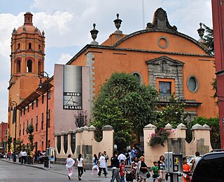
Santo Domingo in Mexico City refers to the Church of Santo Domingo and its Plaza, also called Santo Domingo. Both are located three blocks north of the Mexico City Metropolitan Cathedral following República de Brasil Street with Belisario Dominguez Street separating the two.

The Nacional Monte de Piedad is a not-for-profit institution and pawnshop whose main office is located just off the Zócalo, or main plaza of Mexico City. It was commanded to be built between 1774 and 1777 by Don Pedro Romero de Terreros, the Count of Regla as part of a movement to provide interest-free or low-interest loans to the poor. It was recognized as a national charity in 1927 by the Mexican government. In the first decade of the 21st century, it is a fast-growing institution, with over 200 branches all over Mexico and plans to open a branch in every Mexican city.
The Mexico City administrative buildings are two buildings on the south side of the Zócalo in Mexico City divided by the avenue Avenida 20 de Noviembre. They house offices of the governing authority of Mexico City. The building to the west of 20 de Noviembre is the older one and has been the site of city administration since the Conquest. The one to the east is newer, built in the 20th century.

The Palace of Iturbide is a large palatial residence located in the historic center of Mexico City at Madero Street #17. It was built by the Count of San Mateo Valparaíso as a wedding gift for his daughter. It gained the name “Palace of Iturbide” because Agustín de Iturbide lived there and accepted the crown of the First Mexican Empire at the palace after independence from Spain. Today, the restored building houses the Fomento Cultural Banamex; it has been renamed the Palacio de Cultura Banamex.

Colegio de San Ildefonso, currently is a museum and cultural center in Mexico City, considered to be the birthplace of the Mexican muralism movement. San Ildefonso began as a prestigious Jesuit boarding school, and after the Reform War it gained educational prestige again as National Preparatory School. This school and the building closed completely in 1978, then reopened as a museum and cultural center in 1992. The museum has permanent and temporary art and archeological exhibitions in addition to the many murals painted on its walls by José Clemente Orozco, Fernando Leal, Diego Rivera and others. The complex is located between San Ildefonso Street and Justo Sierra Street in the historic center of Mexico City.
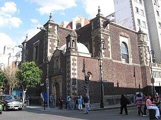
The Palace of the Inquisition stands on the corner of República de Brasil and República de Venezuela streets in Mexico City, Mexico. As neither side of the building faces Santo Domingo Plaza, the entrance is placed at a canted corner to face the plaza. Its long association with the Inquisition, which ended during the Mexican War of Independence, made it difficult to convert to other purposes. However, it eventually became the School of Medicine for the reconstructed National University. When UNAM moved to the Ciudad Universitaria in the 1950s, it retained ownership of this building, eventually converting the structure in what is today the Museum of Mexican Medicine.
The San Pedro y San Pablo College is a colonial church and former Jesuit house (collegium), built in the late 16th and early 17th centuries, located in the historical center of Mexico City, Mexico.

The House of the Marquis of Uluapa is located on 5 de Febrero Street in the historic center of Mexico City, Mexico. No one knows who originally owned the house but it has been proven that it never belonged to the Marquis of Uluapa. For this reason, it is officially archived only as “the house at number 18, 5 de Febrero Street.” However, the house remains popularly known as the House of the Marquis of Uluapa.
The Secretariat of Public Education Main Headquarters building is on the northeast corner of San Ildefonso and República de Argentina streets in the historic center of Mexico City, and used to be part of the largest and most sumptuous convents in New Spain. It was secularized in the 19th century and then taken over by the then-new Secretariat of Public Education after the Mexican Revolution in the early 20th century. The new agency did extensive remodeling work on the building, including covering nearly all the walls of the two inner courtyards with murals. These murals include Diego Rivera’s first large-scale mural project, which he completed in 1928.

The Palacio de la Aduana is a building in Málaga, Andalusia, Spain, originally a customs house for the Port of Málaga.
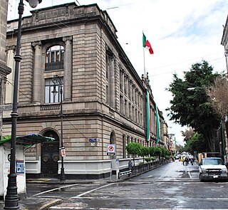
The Library of the Congress of Mexico mostly contains the records of the country's legislative sessions since its Independence. It is located at 29 Tacuba Street, near the corner with Bolivar in the historic center of Mexico City. This structure was originally part of a Poor Clares convent founded in the 16th century, but was confiscated by the Reform Laws of the 19th century. Since then, this building has been used as government offices, barracks and even a canteen. It current use was established in 1962, when the Library of Congress was founded by the Mexican government. Since then, the archives it houses have outgrown the building and a number are housed at the Palacio Legislativo de San Lázaro as well.

The Aduana Building, also known as the Intendencia, was a Spanish colonial structure in Manila, Philippines that housed several government offices through the years. It is located in front of the BPI Intramuros at Plaza España, Soriano (Aduana) Ave. corner Muralla St. in Intramuros.
Plaza Mexico is a historic riverside square in Manila, Philippines, located at the west end of Magallanes Drive and Riverside Drive in Intramuros bordering the Pasig River in the north. It is surrounded by the Aduana Building on the south, the Bureau of Immigration Building on the east and the ruins of the Bastión de Maestranza and Puerta de Almacenes on the west. The Pasig River Ferry has a station also named Plaza Mexico located northeast of the square behind the Immigration building. The square was named Plaza Mexico in 1964 to commemorate the 4th centenary of the expedition of Miguel López de Legazpi and Andres de Urdaneta from New Spain (Mexico) and the historic Manila-Acapulco galleon trade relations between the two nations that lasted 250 years.

Plaza de España, also known simply as Plaza España, is a diminutive open space in Intramuros, Manila, Philippines formed by the intersection of Andres Soriano Avenue, Solana Street and Muralla Street. It is a triangular "square" which features a monument to King Philip II of Spain after whom the Philippines was named. The square is one of 47 parks and plazas in the City of Manila maintained by the city's Park Development Office in partnership with the Intramuros Administration. It is surrounded by the Aduana Building, the BPI Intramuros building which replaced the old Santo Domingo Church destroyed during World War II, and the Banco Filipino condominium building built on a portion of the old Ayuntamiento de Manila.
The Convent of Santa Inés was a convent in Mexico City from 1600 to 1861, later separated into the present day Church of Santa Inés and José Luis Cuevas Museum, located just off the Zócalo within the Historic center of Mexico City.


