List of colonial non-religious buildings in Mexico City

Last updated

This is a list of the preserved important colonial government and civil buildings in Mexico City , the capital of Mexico.

Contents

Mexico City was traditionally known as La Ciudad de los Palacios ("the City of the Palaces"), a nickname attributed to Baron Alexander von Humboldt when visiting the city in the 19th century.

Aside from being a notable city in colonial times, the city grew in the 20th century enormously in terms of population, adhering to over a hundred of suburbs close to the city (former suburbs today called "pueblos originarios" or "colonias").

List

NameImageBuiltArchitectural styleArchitect(s)Belonged to the religious orderSourceLocationID
Casa de los Azulejos or
Palacio de los Condes del Valle de Orizaba (it currently houses a restaurant)
Casa de Azulejos 3.jpg 16th century-1737 Baroque and Azulejos Count of the Valle de Orizaba family [1]
Location map Mexico City.png
Red pog.svg
Location within Mexico City
General information
LocationAv Francisco I. Madero 4, Centro. 06500, Centro Histórico
Coordinates 19°26′3.19″N99°8′24.74″W / 19.4342194°N 99.1402056°W / 19.4342194; -99.1402056 (Casa de los Azulejos)
National Palace (in the colonial the Palace of the Viceroys of Mexico) Palacio Nacional, Mexico D.F., Mexico, 2013-10-16, DD 119.JPG 1522-1845 Baroque Claudio de Arciniega, Juan Gómez de Trasmonte [2]
Location map Mexico City.png
Red pog.svg
Location within Mexico City
General information
LocationPlaza de la Constitución s/n, Centro (ZMH "A")
Coordinates 19°25′57″N99°07′52″W / 19.43250°N 99.13111°W / 19.43250; -99.13111 (Palacio Nacional (México))
00208
House of the First Printing Press in the Americas CasaImprentaDF.JPG 1524 Gerónimo de Aguilar [3]
Location map Mexico City.png
Red pog.svg
Location within Mexico City
General information
LocationLicenciado Verdad 10, Centro Histórico (ZMH "A")
Coordinates 19°26′0.82″N99°7′51.53″W / 19.4335611°N 99.1309806°W / 19.4335611; -99.1309806 (Home of America's First Printing Press, Mexico City)
05346
Casa del Mayorazgo de Medina Casa del mayorazgo de Medina.jpg 1525-18th century Baroque [4]
Location map Mexico City.png
Red pog.svg
Location within Mexico City
General information
LocationRepública de Cuba 99, Centro (ZMH "A")
Coordinates 19°26′12″N99°08′02″W / 19.43667°N 99.13389°W / 19.43667; -99.13389 (Casa del Mayorazgo de Medina)
I-09-00791
Old Archbishop's Palace (currently the Museum of the Ministry of Finance) Arzobispado Mexico.jpg 1530-1771 Baroque José Miguel de Rivera Saravia [5]
Location map Mexico City.png
Red pog.svg
Location within Mexico City
General information
LocationMoneda 4, Centro Histórico (ZMH "A")
Coordinates 19°26′01″N99°07′53″W / 19.43361°N 99.13139°W / 19.43361; -99.13139 (Antiguo Palacio del Arzobispado)
00277
Palacio de los Condes de Santiago de Calimaya (currently the Museum of Mexico City) Museo de la Ciudad de Mexico. Fotografia Viviana Martinez 2017.jpg 1536-1779 Baroque Francisco Antonio de Guerrero y Torres [6]
Location map Mexico City.png
Red pog.svg
Location within Mexico City
General information
LocationJosé María Pino Suárez 30, Centro (ZMH "A")
Coordinates 19°25′45.12″N99°7′57.17″W / 19.4292000°N 99.1325472°W / 19.4292000; -99.1325472 (Museum of Mexico City)
00241
Academia de San Carlos (currently is part of the UNAM) Academia de San Carlos esquina de Calle de Moneda y Academia.JPG 1540-1781 Neoclassical [7]
Location map Mexico City.png
Red pog.svg
Location within Mexico City
General information
LocationLa Academia 22, Centro Histórico de la Cdad. de México
Coordinates 19°25′59.11″N99°7′43.84″W / 19.4330861°N 99.1288444°W / 19.4330861; -99.1288444 (Academia de San Carlos)
00120
Casa de las Gallas (it was a colonial brothel) Casa de las Gayas.jpg 1542-16th century Baroque [8]
General information
Locationcalle de Mesones número 167
Colegio de San Ildefonso (it currently houses a museum) Museo de la Luz.jpg 1588-1749 Churrigueresque Jesuits [9] [10]
Location map Mexico City.png
Red pog.svg
Location within Mexico City
General information
LocationJusto Sierra 16, Centro Histórico de la Cdad. de México
Coordinates 19°26′9.78″N99°7′50.37″W / 19.4360500°N 99.1306583°W / 19.4360500; -99.1306583 (Colegio de San Ildefonso)
00273
Centro Cultural Casa Talavera Casa talavera.jpg 16th century-1711 Baroque Marquess of San Miguel de Aguayo [11]
Location map Mexico City.png
Red pog.svg
Location within Mexico City
General information
LocationBarrio de Temazcaltitlán (Barrio de los temascales), Talavera 20, Centro Histórico
Coordinates 19°25′42″N99°07′39″W / 19.42833°N 99.12750°W / 19.42833; -99.12750 (Casa Talavera)
00243
Colegio de Cristo (currently houses the Caricature Museum) FacadeCaricatureMusDF.JPG 1612-1694 Churrigueresque Jesuits [12]
Location map Mexico City.png
Red pog.svg
Location within Mexico City
General information
LocationCentro Histórico
Coordinates 19°26′08″N99°07′58″W / 19.43556°N 99.13278°W / 19.43556; -99.13278 (Colegio de Cristo)
00223
Hospicio de San Nicolás Tolentino Hospicio san Nicolas.jpg 17th century Order of Augustinian Recollects [13]
Location map Mexico City.png
Red pog.svg
Location within Mexico City
General information
LocationRepública de Guatemala 84, Centro (ZMH "A")
Coordinates 19°26′05″N99°07′43″W / 19.43472°N 99.12861°W / 19.43472; -99.12861 (Hospicio de San Nicolás Tolentino)
00257
Portal de los Evangelistas Mexico City 2015 039.jpg 1685-18th centuryDiego Pedraza, Juan Jaramillo [14]
Location map Mexico City.png
Red pog.svg
Location within Mexico City
General information
Location Plaza de Santo Domingo, República de Brasil, Centro Histórico de la Cdad. de México
Coordinates 19°26′14″N99°08′02″W / 19.43722°N 99.13389°W / 19.43722; -99.13389 (Portal de los Evangelistas)
Casa de los Condes de Miravalle (currently houses a hotel) Casa de los condes de Miravalle.jpg 1690-early 18th centuryAlonso Dávalos Bracamontes de Ulibarri y de la Cueva, 1st Count of Miravalle [15]
Location map Mexico City.png
Red pog.svg
Location within Mexico City
General information
LocationIsabel la Católica 30, Centro (ZMH "A")
Coordinates 19°25′58″N99°08′10″W / 19.43278°N 99.13611°W / 19.43278; -99.13611 (Casa de los Condes de Miravalle)
I-09-01023
Hospital del Divino Salvador 20200627 111347 HDR.jpg 1700-1809 Congregación del Divino Salvador, Society of Jesus [16]
Location map Mexico City.png
Red pog.svg
Location within Mexico City
General information
LocationDonceles 39, Centro (ZMH "A")
Coordinates 19°26′11″N99°08′14″W / 19.43639°N 99.13722°W / 19.43639; -99.13722 (Hospital del Divino Salvador)
00221
Alhóndiga of Mexico City Edificio de la Alhondiga.JPG 1711
List of colonial non-religious buildings in Mexico City
General information
LocationAlhóndiga 12, Centro Histórico de la Cdad. de México
Coordinates 19°25′54″N99°07′37″W / 19.43167°N 99.12694°W / 19.43167; -99.12694 (Alhóndiga of Mexico City)
00019
Old Customs Building 00187 Aduana de Santo Domingo o Casa de los Marqueses de Villa Mayor.JPG 1729-1790 Manuel Joseph de Herrera, Pedro Arrieta, Miguel Costansó [17]
Location map Mexico City.png
Red pog.svg
Location within Mexico City
General information
LocationRepública de Brasil #31, Centro Histórico de la Cdad. de México (ZMH "A")
Coordinates 19°26′14.01″N99°8′0.68″W / 19.4372250°N 99.1335222°W / 19.4372250; -99.1335222 (Old Customs Building)
00187
Old Mint of Mexico (currently houses the National Museum of Cultures) ANTIGUA CASA DE MONEDA 1.JPG 1731-1734 Luis Diez Navarro y Albuquerque, Bernardino de Orduña [18]
Location map Mexico City.png
Red pog.svg
Location within Mexico City
General information
Coordinates 19°26′00″N99°07′49″W / 19.43333°N 99.13028°W / 19.43333; -99.13028 (Old Mint of Mexico)
M-09-066-05-00
Palace of the Inquisition (it currently houses the Museum of Mexican Medicine) FacadeInquisDF.JPG 1732-1736 Baroque Pedro de Arrieta [19]
Location map Mexico City.png
Red pog.svg
Location within Mexico City
General information
LocationRepública de Brasil 33, Centro Histórico de la Cdad. de México (ZMH "A")
Coordinates 19°26′16.34″N99°8′0.18″W / 19.4378722°N 99.1333833°W / 19.4378722; -99.1333833 (Palace of the Inquisition)
00188
Palacio del Marqués de Selva Nevada Marques de selva nevada.jpg 1753 Baroque [20]
Location map Mexico City.png
Red pog.svg
Location within Mexico City
General information
LocationCalle de Venustiano Carranza 49, Centro Histórico
Coordinates 19°21′01″N99°09′43″W / 19.35028°N 99.16194°W / 19.35028; -99.16194 (Palacio del Marqués de Selva Nevada)
00101
Old Town Hall of Coyoacán (it is still the seat of the town hall) Coyoacan 001.jpg 1755-1756 [21]
Location map Mexico City.png
Red pog.svg
Location within Mexico City
General information
LocationPlaza Hidalgo 1, Villa Coyoacán (ZMH)
Coordinates 19°21′01″N99°09′43″W / 19.35028°N 99.16194°W / 19.35028; -99.16194 (Palace of the Inquisition)
00101
Casas de los Camilos Casa de las Calderas restaurada.jpg 1756-early 19th century Baroque Camillians [22]
Location map Mexico City.png
Red pog.svg
Location within Mexico City
General information
LocationSan Jerónimo 114, (ZMH "A") Centro Histórico
Coordinates 19°25′35″N99°07′54″W / 19.42639°N 99.13167°W / 19.42639; -99.13167 (Casas de los Camilos)
Palacio de los Condes de Heras y Soto Casa de Soto.jpg 1760-1769 Baroque [23]
Location map Mexico City.png
Red pog.svg
Location within Mexico City
General information
Locationesquina que conforman las calles de República de Chile y la Calle de los Donceles, antes las calles de Manrique y la Canoa, Centro Histórico
Coordinates 19°26′10″N99°08′10″W / 19.43611°N 99.13611°W / 19.43611; -99.13611 (Palacio de los Condes de Heras y Soto)
06428
Casa de los Condes de San Bartolomé de Xala Conde de xala.jpg 1763-1764 Churrigueresque Lorenzo Rodríguez [24]
Location map Mexico City.png
Red pog.svg
Location within Mexico City
General information
LocationVenustiano Carranza 73, Centro Histórico (ZMH "A")
Coordinates 19°25′52″N99°08′07″W / 19.43111°N 99.13528°W / 19.43111; -99.13528 (Casa de los Condes de San Bartolomé de Xala)
06428
Colegio de las Vizcaínas (it currently a preparatory college) Colegio de las Vizcainas.jpg 1767 Baroque José Miguel de Rivera Saravia [25]
Location map Mexico City.png
Red pog.svg
Location within Mexico City
General information
LocationVizcaínas 21, colonia Centro Histórico
Coordinates 19°25′42″N99°08′27″W / 19.42833°N 99.14083°W / 19.42833; -99.14083 (Colegio de las Vizcaínas)
Palacio de los Condes de San Mateo de Valparaíso (it currently the seat of the Foro Valparaíso) Palacio de los Condes de San Mateo de Valparaiso.jpg 1769-1772 New Spanish Baroque Francisco Antonio de Guerrero y Torres [26]
Location map Mexico City.png
Red pog.svg
Location within Mexico City
General information
LocationCalles de Isabel la Católica and Venustiano Carranza in the Centro Histórico de la Ciudad de México.
Coordinates 19°25′54″N99°08′11″W / 19.43167°N 99.13639°W / 19.43167; -99.13639 (Colegio de las Vizcaínas)
Palacio de Iturbide (now houses the Palacio de Cultura Citibanamex museum) FacadeIturbideDF.JPG 1779-1785 New Spanish Baroque Francisco Antonio de Guerrero y Torres and Agustín Durán [27]
Location map Mexico City.png
Red pog.svg
Location within Mexico City
General information
LocationAv Francisco I. Madero 17, Centro Histórico de la Cdad. de México
Coordinates 19°26′1.55″N99°8′19.92″W / 19.4337639°N 99.1388667°W / 19.4337639; -99.1388667 (Palacio de Iturbide)
Chapultepec Castle (a former royal palace) Castillo de Chapultepec (Museo Nacional de Historia).JPG 1785-1864 Neoclassical Eleuterio Méndez, Ramón Cruz Arango, Julius Hofmann, Carl Gangolf Kayser, Carlos Schaffer [28]
Location map Mexico City.png
Red pog.svg
Location within Mexico City
General information
LocationBosque de Chapultepec I Secc, Miguel Hidalgo
Coordinates 19°25′14″N99°10′54″W / 19.42056°N 99.18167°W / 19.42056; -99.18167 (Chapultepec Castle)
Palacio del Conde de Buenavista (currently houses the Museo Nacional de San Carlos) San carlos fachada.jpg late 18th century-1805 Neoclassical Manuel Tolsá [29]
Location map Mexico City.png
Red pog.svg
Location within Mexico City
General information
LocationAv. México - Tenochtitlan 50
Coordinates 19°26′17″N99°09′07″W / 19.43806°N 99.15194°W / 19.43806; -99.15194 (Museo Nacional de San Carlos)
Royal Tobacco Factory Centro de la Imagen, Mexico.jpg 1793-1807 Neoclassical José Antonio González Velázquez, Miguel Costansó, Ignacio Castera [30]
Location map Mexico City.png
Red pog.svg
Location within Mexico City
General information
LocationPlaza de La Ciudadela 4 (06040)
Coordinates 19°25′43″N99°08′58″W / 19.42861°N 99.14944°W / 19.42861; -99.14944 (La Ciudadela)
00201
Casa de la Marquesa de Selva Nevada Fachada de la casa de la marquesa de la Selva Nevada.JPG 18th century Baroque [ citation needed ]
General information
LocationEsquina con la Plaza de los Licenciados, entre las calles Hidalgo y Reyna en San Ángel en la Delegación Álvaro Obregón
Palacio de Minería Palacio de Mineria Tacuba 3 Centro Historico Cd de Mexico.JPG 1797-1813 Neoclassical Manuel Tolsá [31]
Location map Mexico City.png
Red pog.svg
Location within Mexico City
General information
LocationTacuba 3, Centro (ZMH "A")
Coordinates 19°26′08″N99°08′22″W / 19.43556°N 99.13944°W / 19.43556; -99.13944 (Palacio de Minería)
00205

See also

Related Research Articles

<span class="mw-page-title-main">Coyoacán</span> Borough in Mexico City, Mexico

Coyoacán is a borough in Mexico City. The former village is now the borough's "historic center". The name comes from Nahuatl and most likely means "place of coyotes", when the Aztecs named a pre-Hispanic village on the southern shore of Lake Texcoco dominated by the Tepanec people. Against Aztec domination, these people allied with the Spanish, who used the area as a headquarters during the Spanish conquest of the Aztec Empire and made it the first capital of New Spain between 1521 and 1523.

<span class="mw-page-title-main">Historic center of Mexico City</span> Place in Mexico City, Mexico

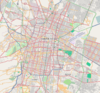
The historic center of Mexico City, also known as the Centro or Centro Histórico, is the central neighborhood in Mexico City, Mexico, focused on the Zócalo and extending in all directions for a number of blocks, with its farthest extent being west to the Alameda Central. The Zocalo is the largest plaza in Latin America. It can hold up to nearly 100,000 people.

<span class="mw-page-title-main">Escuela Nacional Preparatoria</span> English premie feos, secondary school in Mexico City, Mexico

The Escuela Nacional Preparatoria (ENP), the oldest senior High School system in Mexico, belonging to the National Autonomous University of Mexico (UNAM), opened its doors on February 1, 1868. It was founded by Gabino Barreda, M.D., following orders of then President of Mexico Benito Juárez. It is also modern UNAM's oldest institution.

<span class="mw-page-title-main">Museo de la Secretaría de Hacienda y Crédito Público</span>

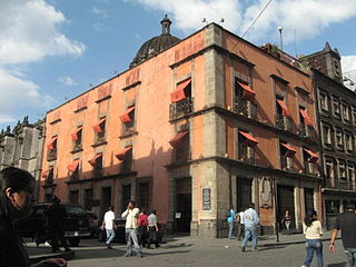
The Museo de la Secretaría de Hacienda y Crédito Público is an art museum located in the historic center of Mexico City. It is housed in what was the Palacio del Arzobispado, built in 1530 under Friar Juan de Zumárraga on the base of the destroyed pyramid dedicated to the Aztec god Tezcatlipoca. It remained the archbishphoric until 1867 when the Finance Ministry Accountancy Department was established there. The modern museum houses an exhibit dedicated to this god as well as a large art collection.

<span class="mw-page-title-main">Santo Domingo (Mexico City)</span>

Santo Domingo in Mexico City refers to the Church of Santo Domingo and its Plaza, also called Santo Domingo. Both are located three blocks north of the Mexico City Metropolitan Cathedral following República de Brasil Street with Belisario Dominguez Street separating the two.

<span class="mw-page-title-main">Iglesia de San Bernardo, Mexico City</span> Church in Mexico City, Mexico

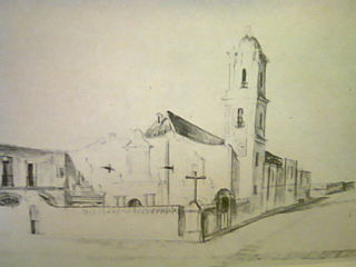
The Church of San Bernardo stands at the corner of Avenida 20 de Noviembre and Venustiano Carranza Street just south of the Zocalo or main plaza of Mexico City. It was part of a convent of the same name that was founded in 1636, but was closed along with all convents and monasteries during the La Reforma period in 1861. Currently, only the church remains of the convent complex.

The Mexico City administrative buildings are two buildings on the south side of the Zócalo in Mexico City divided by the avenue Avenida 20 de Noviembre. They house offices of the governing authority of Mexico City. The building to the west of 20 de Noviembre is the older one and has been the site of city administration since the Conquest. The one to the east is newer, built in the 20th century.

<span class="mw-page-title-main">House of the First Print Shop in the Americas</span> Building in Mexico City, Mexico

The House of the First Printing Press in the Americas at the corner of Moneda and Licenciado Primo Verdad streets in Mexico City was the home of the first printing press/print shop in the New World. The printer Juan Pablos oversaw the printing of at least 35 books at this print shop between 1539, the date of the first book printed in the Americas, and his death in 1560.

<span class="mw-page-title-main">Convent of La Merced, Mexico City</span>

The Convent of Nuestra Señora de La Merced was a Roman Catholic colonial religious complex in present-day Historic center of Mexico City, that was destroyed to give more space to future buildings. The cloister is all that is left of a monastery complex built in the late 16th and early 17th century by the Mercedarian order. It is located on Uruguay and Talavera Streets in the historic downtown of Mexico City. The complex lent its name to the area around it, La Merced, which in turn, inspired the name of the metro station and the well-known neighborhood Market.

<span class="mw-page-title-main">Caricature Museum, Mexico City</span> Building in Mexico City, Mexico

The Caricature Museum is located in an 18th-century Baroque building in the historic center of Mexico City. It was opened in 1987 to preserve and promote the history of Mexican cartooning, done for both political and entertainment purposes. The historic building it occupies was originally the home of Cristo College, a royal college established in 1612.

<span class="mw-page-title-main">Palace of the Inquisition</span>

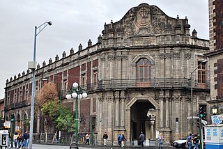
The Palace of the Inquisition stands on the corner of República de Brasil and República de Venezuela streets in Mexico City, Mexico. As neither side of the building faces Santo Domingo Plaza, the entrance is placed at a canted corner to face the plaza. Its long association with the Inquisition, which ended during the Mexican War of Independence, made it difficult to convert to other purposes. However, it eventually became the School of Medicine for the reconstructed National University. When UNAM moved to the Ciudad Universitaria in the 1950s, it retained ownership of this building, eventually converting the structure in what is today the Museum of Mexican Medicine.

<span class="mw-page-title-main">Tlaxcala House, Mexico City</span>

The Tlaxcala House is located at 40 San Ildefonso Street in the historic center of Mexico City. It is an example of a typical middle-class home of the 18th century, meant that its style is somewhere between the mansions of the wealthy and the houses of the commoners of the time.

<span class="mw-page-title-main">House of the Marquis of Uluapa, Mexico City</span>

The House of the Marquis of Uluapa is located on 5 de Febrero Street in the historic center of Mexico City, Mexico. No one knows who originally owned the house but it has been proven that it never belonged to the Marquis of Uluapa. For this reason, it is officially archived only as “the house at number 18, 5 de Febrero Street.” However, the house remains popularly known as the House of the Marquis of Uluapa.

<span class="mw-page-title-main">House of the Count De la Torre Cosío y la Cortina, Mexico City</span> Building in Mexico City, Mexico

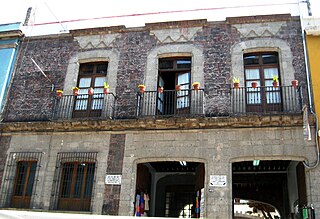
The house of the Counts of la Torre Cosío y la Cortina, located on 94 Republica de Uruguay Street in the historic center of Mexico City was built in 1781 and the scene for one of Mexico City's legends. The house is considered to be a fine example of civil architecture of the 18th century, shortly after the First Count De la Cortina received his noble title in 1773. The most notable member of this family would be Justo Gómez de la Cortina who was an important social and political figure in New Spain at the beginning of the 19th century.

<span class="mw-page-title-main">Museum of Mexico City</span> Art museum in Mexico

The Museum of Mexico City is located at Pino Suarez 30, a few blocks south of the Zocalo, on what was the Iztapalapa Causeway, near where Hernán Cortés and Moctezuma II met for the first time. This building used to be the palace of the Counts of Santiago de Calimaya, who were the descendants of one of the conquistadors with Cortés. The house was extensively remodeled during the colony to much the appearance that it has today and remained in the family until 1960, when the Mexico City government acquired it from them in order to found the Museum that is found there today. The museum contains a number of elements of the old palace as well as 26 rooms dedicated to the history and development of Mexico City from Aztec times to the present. It also contains a library and the studios of painter Joaquín Clausell, who lived here in the late 19th and early 20th centuries.

<span class="mw-page-title-main">Borda House, Mexico City</span>

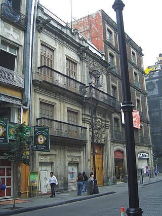
The Borda House, located on 27, 29 and 33 Madero Street, and 26-28 Bolivar streets in the historic center of Mexico City, originally belonged to the Frenchman José de la Borda who was one of the richest men in New Spain in the 18th century. It stands out due to its notable architectural features such as the sculpted stone decorative details on the ground floor. The original building encompassed the entire city block. It had various inner courtyards, and Borda had an ironwork balcony built all the way around the building, supported by angles in the shape of rooster feet. This allowed one to walk all the way around the building on the outside.

<span class="mw-page-title-main">Church of Santa Inés</span> Church in Mexico City, Mexico

The Church of Santa Inés is a church located at 26 Moneda Street, just northeast of the Zócalo, Mexico City, Mexico. The building, formerly part of the Convent of Santa Inés, is considered to be a mix of styles between Mexican Baroque and Neoclassical. The church was completely finished in 1770.

<span class="mw-page-title-main">Convent of Santa Inés</span>

The Convent of Santa Inés was a convent in Mexico City from 1600 to 1861, later separated into the present day Church of Santa Inés and José Luis Cuevas Museum, located just off the Zócalo within the Historic center of Mexico City.

References

  1. Luis Gonzalez Obregón (1909). México viejo y anecdótico (PDF). Robarts Toronto. p. 201.
  2. Guillermo Tovar de Teresa (2006). El Pegaso, o, El mundo barroco novohispano en el siglo XVII. Editorial Renacimiento. p. 225. ISBN   84-8472-281-3.
  3. "Casa de a la Primera Imprenta de América". Instituto de Administración y Avalúos de Bienes Nacionales. 2002.
  4. "Casa del Mayorazgo de Medina". thecity.mx.
  5. Efraín Castro Morales (2003). Palacio del Arzobispado de México (Primera ed.). Museo Mexicano. p. 181. ISBN   968-5795-00-2.
  6. Angélica Oviedo Herrerias (1996). Palacio de los Condes de Santiago de Calimaya. Vol. First Edition. Instituto Nacional de Antropología e Historia.
  7. Galindo, Carmen; Magdelena Galindo (2002). Mexico City Historic Center. Mexico City: Ediciones Nueva Guia. pp.  70–72. ISBN   968-5437-29-7.
  8. "La Casa donde antiguamente se vendían caricias". guiacapital.com.mx.
  9. Galindo, Carmen; Magdelena Galindo (2002). Mexico City Historic Center. Mexico City: Ediciones Nueva Guia. pp.  86–91. ISBN   968-5437-29-7.
  10. "Acerca del museo". Colegio de San Idelfonso Official website.
  11. "Centro Cultural Casa Talavera". Government of Mexico website.
  12. "Colegio de Cristo". Mediateca. Instituto Nacional de Antropología e Historia .
  13. "Recorrido histórico por la nueva sede del CCC". Consultative Council of Sciences of the Presidency of the Republic of Mexico . 27 March 2017.
  14. "Portal de Santo Domingo". thecity.mx.
  15. Garritz, A., p. 25.
  16. "Hospital del Divino Salvador". thecity.mx.
  17. "La Real Aduana de Santo Domingo" (in Spanish). Archived from the original on 2009-06-20. Retrieved 2009-06-09.
  18. María del Carmen Olvera Calvo; Ana Eugenia Reyes y Cabañas (December 2004). "El gremio y la cofradía de los canteros de la Ciudad de México" (PDF). Boletín de Monumentos Históricos INAH. p. 15.
  19. Horz de Via, Elena (1991). Guia Oficial Centro de la Ciudad de Mexico. Mexico City: INAH-SALVAT. pp. 68–69. ISBN   968-32-0540-2.
  20. "Palacio del Marqués de Selva Nevada". mexicocity.cdmx.gob.mx. 10 July 2012.
  21. "Coyoacán: más que un paseo". Delegación Coyoacán. 2009.
  22. Bautista Sandoval, Jesús Eduardo, Las casas de la buena muerte, una búsqueda, una permanencia, Revista Bitácora Arquitectura, No. 23, Facultad de arquitectura de la UNAM, México D.F., 2011
  23. Eugenia Acosta Sol (January 2009). "Casas señoriales del siglo XVIII" (PDF). Revista esencia y espacio. No. 28. p. 46. ISSN   1870-9052.
  24. "Residencia de los condes de San Bartolomé de Xala". cdmx200lugares.com.
  25. Antonio Toussaint (1962). "Colegio de las Vizcainas". Artes de México. Vol. 7, no. 42.
  26. Fernando Arellano (1988). "El arte hispanoamericano". p. 173. ISBN   980-244-017-5.{{cite magazine}}: Cite magazine requires |magazine= (help)
  27. Charles Mikos of Tarrodhaza, Teodoro Amerlinck and Zirion, David Williamson (1994). "The Imperial House of Mexico: The House of Iturbide". “The” Noble House.{{cite web}}: CS1 maint: multiple names: authors list (link)
  28. Hendel, archINFORM – Sascha. "Julius Hofmann". Eng.archinform.net.
  29. José Cortina Goribar (1974). "El palacio del Marqués de Buenavista". Artes de México. No. 179/180. pp. 56–58. JSTOR   24317702.
  30. "Biblioteca de México "José Vasconcelos". Antecedentes históricos". Biblioteca de México.gob.mx.
  31. Elizabeth Fuentes Rojas (2002). La Academia de San Carlos Y Los Constructores Del Neoclasico (First ed.). UNAM. p. 46. ISBN   968-36-9957-X.