Castelforte

Last updated
Castelforte
Comune di Castelforte
Castelforte(LT).JPG
Castelforte-Stemma.png
Location of Castelforte
Castelforte
Italy provincial location map 2016.svg
Red pog.svg
Castelforte
Location of Castelforte in Italy
Italy Lazio location map.svg
Red pog.svg
Castelforte
Castelforte (Lazio)
Coordinates: 41°18′N13°50′E / 41.300°N 13.833°E / 41.300; 13.833
Country Italy
Region Lazio
Province Latina (LT)
Frazioni Suio
Government
  MayorAngelo Felice Pompeo (Civic list)
Area
[1]
  Total29 km2 (11 sq mi)
Elevation
130 m (430 ft)
Population
 (31 December 2017) [2]
  Total4,221
  Density150/km2 (380/sq mi)
Demonym Castelfortesi
Time zone UTC+1 (CET)
  Summer (DST) UTC+2 (CEST)
Postal code
04021
Dialing code 0771
Patron saint St. John the Baptist
Saint dayJune 24
Website Official website

Castelforte is a town and comune in the province of Latina, in the Lazio region of central Italy. It is located at the feet of the Monti Aurunci massif.

Contents

History

Castelforte was founded most likely before the year 1000 AD. According to some scholars, it occupies the ruins of the ancient Auruncan town of Vescia, destroyed by the Romans in 340 BC (the commune includes the ruins of the large Terme Vescinae baths, in what is now the frazione of Suio).

The medieval town (Castrum Forte, meaning "Strong Castle") was a typical stronghold (probably built to counter the Saracen presence at the Garigliano) with a line of wall and rounded towers; the nearby Suio was defended by a castle. Castrum Forte's population was increased in 1320 when people from Suio moved here to flee malaria.

People from Castelforte formed two companies which fought alongside Fra' Diavolo in resistance against the French Napoleonic troops in 179899. This caused them to besiege and storm the town in the latter year. In 1807 Suio, now nearly depopulated, was aggregated to the municipality.

During the battles of Cassino of World War II, Castelforte, part of the German Gustav Line, was heavily bombed by Allied troops (194344). The city suffered hundreds of casualties in the event. There is a museum to commemorate the soldiers and civilians dead during that period.

See also

Related Research Articles

<span class="mw-page-title-main">Magenta, Lombardy</span> Comune in Lombardy, Italy

Magenta is a town and comune in the Metropolitan City of Milan in Lombardy, northern Italy. It became notable as the site of the Battle of Magenta in 1859. The color magenta takes its name from the battle, most likely referring to the uniforms used by Zouave French troops.

<span class="mw-page-title-main">Nettuno</span> Comune in Lazio, Italy

Nettuno is a town and comune of the Metropolitan City of Rome in the Lazio region of central Italy, 60 kilometres south of Rome. A resort city and agricultural center on the Tyrrhenian Sea, it has a population of approximately 50,000.

<span class="mw-page-title-main">Follonica</span> Comune in Tuscany, Italy

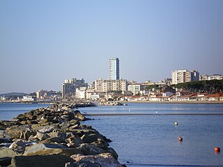
Follonica is a town and comune (township) of province of Grosseto in the Italian region of Tuscany, on the Gulf of Follonica, about 40 kilometres (25 mi) northwest of the city of Grosseto.

<span class="mw-page-title-main">Bracciano</span> Comune in Lazio, Italy

Bracciano is a small town in the Italian region of Lazio, 30 kilometres northwest of Rome. The town is famous for its volcanic lake and for a particularly well-preserved medieval castle Castello Orsini-Odescalchi. The lake is widely used for sailing and is popular with tourists; the castle has hosted a number of events, especially weddings of actors and singers.

<span class="mw-page-title-main">Bertinoro</span> Comune in Emilia-Romagna, Italy

Bertinoro is a comune (municipality) in the province of Forlì-Cesena, in the Italian region of Emilia-Romagna. It is located on hill Mount Cesubeo, in Romagna, a few kilometers from the Via Emilia.

<span class="mw-page-title-main">Nerola</span> Comune in Lazio, Italy

Nerola is a town and comune of the Metropolitan City of Rome, Latium, Italy.

<span class="mw-page-title-main">Battle of Garigliano (1503)</span> Part of the Third Italian War

The Battle of Garigliano was fought on 29 December 1503 between a Spanish army under Gonzalo Fernández de Córdoba and a French army commanded by Ludovico II, Marquis of Saluzzo.

Cerea is a town and comune in the province of Verona, Veneto, northern Italy.

<span class="mw-page-title-main">Coriano</span> Comune in Emilia-Romagna, Italy

Coriano is a comune in the province of Rimini. This town is known for being the town of the Motorcycle World Champion, in 250cc class, Marco Simoncelli.

<span class="mw-page-title-main">Cervinara</span> Comune in Campania, Italy

Cervinara is a town and comune in the province of Avellino, Campania, Italy.

Castelluccio Valmaggiore is a town and comune in the province of Foggia in the Apulia region of southeast Italy.

<span class="mw-page-title-main">Castrovillari</span> Comune in Calabria, Italy

Castrovillari is a town and comune in the province of Cosenza in the Calabria region of southern Italy.

<span class="mw-page-title-main">Altavilla Vicentina</span> Comune in Veneto, Italy

Altavilla Vicentina is a town and comune in the province of Vicenza, Veneto, northern Italy. It is located southwest of Vicenza.

<span class="mw-page-title-main">Carrù</span> Comune in Piedmont, Italy

Carrù is a comune (municipality) in the Province of Cuneo in the Italian region Piedmont, located about 70 kilometres (43 mi) south of Turin and about 30 kilometres (19 mi) northeast of Cuneo.

<span class="mw-page-title-main">Arquata Scrivia</span> Comune in Piedmont, Italy

Arquata Scrivia is a comune (municipality) in the Province of Alessandria in the Italian region Piedmont, located about 100 kilometres (62 mi) southeast of Turin and about 35 kilometres (22 mi) southeast of Alessandria.

<span class="mw-page-title-main">Volpedo</span> Comune in Piedmont, Italy

Volpedo is a comune (municipality) in the province of Alessandria, in the Italian region of Piedmont, located about 100 kilometres (62 mi) east of Turin and about 30 kilometres (19 mi) east of Alessandria.

<span class="mw-page-title-main">Castel del Rio</span> Comune in Emilia-Romagna, Italy

Castel del Rio is a comune (municipality) in the Metropolitan City of Bologna in the Italian region Emilia-Romagna, located about 35 kilometres (22 mi) southwest of Bologna.

<span class="mw-page-title-main">Bagno di Romagna</span> Comune in Emilia-Romagna, Italy

Bagno di Romagna is a comune (municipality) in the Province of Forlì-Cesena in the Italian region Emilia-Romagna, located about 90 kilometres (56 mi) southeast of Bologna and about 45 kilometres (28 mi) south of Forlì.

<span class="mw-page-title-main">Tavullia</span> Comune in Marche, Italy

Tavullia is a comune (municipality) in the Province of Pesaro and Urbino in the Marche region of Italy, located about 70 kilometres (43 mi) northwest of Ancona and about 15 kilometres (9 mi) southwest of Pesaro. Until 13 December 1938, it was known as Tomba di Pesaro.

Sant'Apollinare is a comune (municipality) in the Province of Frosinone in the Italian region Lazio, located about 120 kilometres (75 mi) southeast of Rome and about 50 kilometres (31 mi) southeast of Frosinone.

References

  1. "Superficie di Comuni Province e Regioni italiane al 9 ottobre 2011". Italian National Institute of Statistics. Retrieved 16 March 2019.
  2. "Popolazione Residente al 1° Gennaio 2018". Italian National Institute of Statistics. Retrieved 16 March 2019.

Commons-logo.svg Media related to Castelforte at Wikimedia Commons