Villanova d'Asti is a town and comune in the province of Asti, Piedmont, northern Italy. It has around 5,000 inhabitants. The economy is based on a mixture of agriculture and industry.

Cisterna di Latina is a town and comune in the province of Latina in Lazio, of central Italy. It was the scene of the Battle of Cisterna in January 1944.

Fondi is a city and comune in the province of Latina, Lazio, central Italy, halfway between Rome and Naples. As of 2017, the city had a population of 39,800. The city has experienced steady population growth since the early 2000s, though this has slowed in recent years.
Sezze is a town and comune in the Province of Latina, central Italy, about 65 kilometres (40 mi) south of Rome and 10 kilometres (6 mi) from the Mediterranean coast. Sezze's historical center of is on a high hill commanding the Pontine plain.

Alife is a town and comune in the Province of Caserta (Campania), Italy. It is located in the Volturno valley, and is a flourishing centre of agricultural production. The comune was formerly inhabited by Arbëreshë and Jewish communities, who have since assimilated.

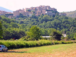
Sermoneta is a hill town and comune in the province of Latina (Lazio), central Italy.

Monte San Biagio is a town and comune in the province of Latina, in southern Lazio (Italy). It is located on the slope of a hill part of the Monti Ausoni. Until 1862 it was known as Monticello.
Lenola is a town and comune in the province of Latina, in the Lazio region of central Italy. Its territory is included in the Natural Preserve of the Monti Aurunci.

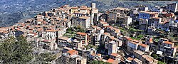
Campodimele is a town and comune in the province of Latina, in the Lazio region of central Italy. It is located on a steep Karstic hill, between the Monti Ausoni and Monti Aurunci ranges.

Montesilvano is a city and comune of the province of Pescara, in the Abruzzo region of Italy. Abruzzo is often called Mare-Monti (Sea-Mountain) region. The name Montesilvano is apparently derived from the Latin which means "woody hill".
Cava Manara is a comune (municipality) in the province of Pavia in the Italian region Lombardy, located about 35 km south of Milan and about 7 km southwest of Pavia, not far from the confluence of the Ticino and the Po rivers.

Bagnoli di Sopra is a comune (municipality) in the Province of Padua in the Italian region Veneto, located about 45 kilometres (28 mi) southwest of Venice and about 25 kilometres (16 mi) south of Padua. As of 31 December 2004, it had a population of 3,837 and an area of 34.9 square kilometres (13.5 sq mi).
Casalserugo is a comune (municipality) in the Province of Padua in the Italian region Veneto, located about 35 kilometres (22 mi) southwest of Venice and about 12 kilometres (7 mi) southeast of Padua. As of 31 December 2004, it had a population of 5,525 and an area of 15.5 square kilometres (6.0 sq mi).
Montaione is a comune (municipality) in the Metropolitan City of Florence in the Italian region Tuscany, located about 35 kilometres (22 mi) southwest of Florence. It is one of I Borghi più belli d'Italia.

Montespertoli is a comune (municipality) in the Metropolitan City of Florence in the Italian region Tuscany, located about 20 kilometres (12 mi) southwest of Florence.
Pontinia is a comune (municipality) in the Province of Latina in the Italian region Lazio, located about 70 kilometres (43 mi) southeast of Rome and about 15 kilometres (9 mi) southeast of Latina.
Roccasecca dei Volsci is a comune (municipality) in the Province of Latina in the Italian region Lazio, located about 80 miles (130 km) southeast of Rome and about 25 kilometres (16 mi) east of Latina.

Filettino is a village and comune in Lazio, Italy, located about 70 kilometres (43 mi) east of Rome and about 30 kilometres (19 mi) north of Frosinone. Filettino borders the following municipalities: Canistro, Capistrello, Cappadocia, Castellafiume, Civitella Roveto, Guarcino, Morino, Trevi nel Lazio and Vallepietra.

Torre Cajetani is a comune (municipality) in the Province of Frosinone in the Italian region Lazio, located about 60 kilometres (37 mi) east of Rome and about 20 kilometres (12 mi) northwest of Frosinone.
Valle di Maddaloni is a comune (municipality) of 2 661 inhabitants in the Province of Caserta in the Italian region Campania, located about 30 kilometres (19 mi) northeast of Naples and about 7 kilometres (4 mi) east of Caserta.