The Allegheny Portage Railroad was the first railroad constructed through the Allegheny Mountains in central Pennsylvania. It operated from 1834 to 1854 as the first transportation infrastructure through the gaps of the Allegheny that connected the midwest to the eastern seaboard across the barrier range of the Allegheny Front. Approximately 36 miles (58 km) long overall, both ends connected to the Pennsylvania Canal, and the system was primarily used as a portage railway, hauling river boats and barges over the divide between the Ohio and the Susquehanna Rivers. Today, the remains of the railroad are preserved within the Allegheny Portage Railroad National Historic Site operated by the National Park Service.
The Johnstown Inclined Plane is a 896.5-foot (273.3 m) funicular in Johnstown, Cambria County, in the U.S. state of Pennsylvania. The incline and its two stations connect the city of Johnstown, situated in a valley at the confluence of the Stonycreek and the Little Conemaugh rivers, to the borough of Westmont on Yoder Hill. The Johnstown Inclined Plane is billed as the "world's steepest vehicular inclined plane". It can carry automobiles and passengers, up or down a slope with a grade of 71.9%. The travel time between stations is 90 seconds.
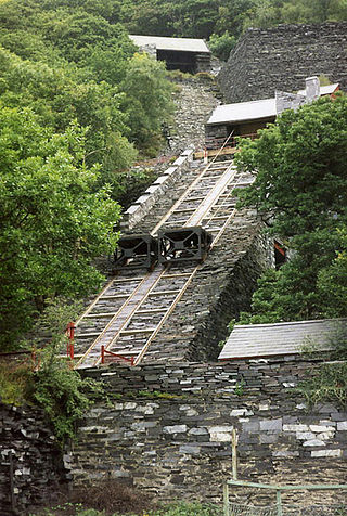
A cable railway is a railway that uses a cable, rope or chain to haul trains. It is a specific type of cable transportation.

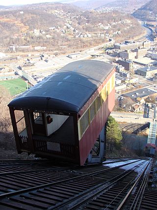
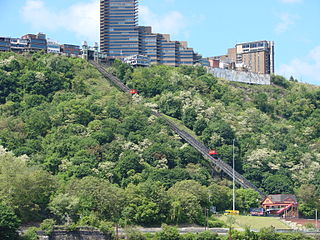
The Monongahela Incline is a funicular located near the Smithfield Street Bridge in Pittsburgh, Pennsylvania. Designed and built by Prussian-born engineer John Endres in 1870, it is the oldest continuously operating funicular in the United States.

A large metropolitan area that is surrounded by rivers and hills, Pittsburgh has an infrastructure system that has been built out over the years to include roads, tunnels, bridges, railroads, inclines, bike paths, and stairways; however, the hills and rivers still form many barriers to transportation within the city.

The Pittsburgh Light Rail is a 26.2-mile (42.2 km) light rail system in Pittsburgh, Pennsylvania, and surrounding suburbs. It operates as a deep-level subway in Downtown Pittsburgh, but runs mostly at-grade in the suburbs south of the city. The system is largely linear in a north-south direction, with one terminus near Pittsburgh's central business district and two termini in the South Hills. The system is owned and operated by Pittsburgh Regional Transit. The T is one of the surviving first-generation streetcar systems in North America, with the oldest portions of the network dating back to 1903 and the Pittsburgh Railways. It is also one of only three light rail systems in the United States that continues to use the broad 5 ft 2+1⁄2 in Pennsylvania Trolley Gauge on its lines instead of the 4 ft 8+1⁄2 instandard gauge. In 2023, the system had a ridership of 3,417,100.

The Knoxville Incline was a broad gauge inclined railway that ran between Pittsburgh's South Side and Allentown neighborhoods. The incline was built in 1890 and had a track gauge of 9 feet (2,700 mm).

Mount Washington Transit Tunnel is an important public transportation link in Pittsburgh, Pennsylvania, United States. The 3,492-foot (1,064 m) tunnel connects Station Square to South Hills Junction, and is used only by Pittsburgh Light Rail cars and buses of the Port Authority of Allegheny County. The tunnel changes 204.54 feet in elevation from its north portal at 750.36 feet above sea level to its south portal at 954.90 feet above sea level, resulting in a grade of 5.86%. With the elimination of bus service in the Downtown Seattle Transit Tunnel in 2019, the Mount Washington Transit Tunnel is the only tunnel in the United States shared by bus and rail services.
The Pittsburgh and Castle Shannon Railroad was a 3 ft 4 in narrow-gauge railroad in Allegheny County, Pennsylvania. Originally built in 1871, it may have been the first American common-carrier narrow-gauge railroad. It purchased a rail line called the Coal Hill Coal Railroad from the Pittsburgh Coal Company, and used a coal mine under Mt. Washington as a tunnel to transport coal from Castle Shannon, Pennsylvania to Pittsburgh. Passenger traffic was added soon afterwards, and the train carried passengers during the day and coal at night. The original plan was to extend the line to Finleyville, Pennsylvania, but the original narrow-gauge line ran only as far as Castle Shannon. The right of way continued as the Pittsburgh, Castle Shannon and Washington Railroad, later to become part of the Pittsburgh Southern Railroad.

The Castle Shannon Incline was a funicular railroad in Pittsburgh, Pennsylvania. It was originally part of the Pittsburgh and Castle Shannon Railroad route to the suburb of Castle Shannon. It replaced an earlier incline dating to 1825 that brought coal down from a mine in Mount Washington.
The Fort Pitt Incline was a 10 ft gauge funicular railroad in the Bluff neighborhood of Pittsburgh. Opened in 1882, the incline ran from 2nd Avenue to Bluff Street, a distance of 350 feet (107 m), and a vertical distance of 135 feet (41 m). The designer was Samuel Diescher.
Samuel Diescher was a prominent Hungarian-American civil and mechanical engineer who had his career in the United States. After being educated at universities in Karlsruhe and Zurich in Europe, he immigrated to the United States in 1866 and settled in Cincinnati, Ohio. There he supervised construction of his first inclined plane. He later moved to Pittsburgh, Pennsylvania, where he worked with John Endres on the Monongahela Incline (1870), the first passenger incline in the city.
The Pittsburgh and Castle Shannon Tunnel, also known as the Mount Washington Coal Tunnel, was a 3 ft 4 in narrow-gauge railway tunnel under Mt. Washington.
The St. Clair Incline, also known as the South Twenty-second Street Incline, was built in 1886–1888 and operated by St. Clair Incline Plane Company. It was a double track incline on the South Side Slopes of Pittsburgh from Josephine St. to Salisbury St. The lower station was near the intersection of S. 22nd Street and Josephine. The upper station was on Salisbury Street across from the former Fort Laughlin site eventually occupied by Arlington Playground. The incline was 2,060 ft (628 m) long, with a vertical rise of 361 ft (110 m). It was designed by engineer J. H. McRoberts. As it carried both freight and passengers over steep tracks laid on the ground, it could be considered to be a cable railway. Its path was not of constant slope but became progressively steeper toward the top, tracing a parabolic arc. It is uncertain exactly when the incline closed permanently, but it was reported as shut down in a 1932 Associated Press article about the "passing" of Pittsburgh's inclines. The structure was dismantled in 1934.

The Pittsburgh and Castle Shannon Plane was a 3 ft 4 in narrow gauge incline railway that ran from the northern end of the Pittsburgh and Castle Shannon Tunnel to Carson Street in Pittsburgh, Pennsylvania.
The Coal Hill Coal Railroad began as a coal mine on the north face of Mt. Washington, then known as "Coal Hill", begun by Jacob Beltzhoover in 1825. This mine was operated by a series of persons, finally by James M. Bailey, who extended the mine completely though the hill to the south side of the hill in 1861. The mine was then sold to the Pittsburgh Coal Company, and rails from the mine were extended an additional one half mile to a new coal mine on the south side of Saw Mill Run. The rails were extended to a third mine, for a total length of one and one half miles. In spite of this short length, the railroad had 3 locomotives and 280 coal cars. The 3 ft 4 in narrow gauge railroad delivered coal from these mines to South Pittsburgh via an inclined plane, which ran from the northern end of the mine to Carson Street in Pittsburgh, Pennsylvania. The railroad was sold by the Pittsburgh Coal Company to the Pittsburgh and Castle Shannon Railroad in 1871. After this sale, the mine was enlarged to form the Pittsburgh and Castle Shannon Tunnel, and the train tracks were extended to Castle Shannon, Pennsylvania.

The Penn Incline, also known as the 17th Street Incline, was a funicular railroad that ran between the Strip and Hill districts in Pittsburgh, Pennsylvania. It operated from 1884 to 1953.
Mount Washington is a hill in Pittsburgh, on the southern banks of the Monongahela River and Ohio River.