
Caledon is a town in the Regional Municipality of Peel in the Greater Toronto Area of Ontario, Canada. The name comes from a shortened form of Caledonia, the Roman name for what is now Scotland. Caledon is primarily rural with a number of hamlets and small villages, but also contains the larger community of Bolton in its southeastern quadrant, adjacent to York Region. Some spillover urbanization also occurs in the south bordering the City of Brampton.

Erin is a town in Wellington County, approximately 80 kilometres (50 mi) northwest of Toronto, Ontario, Canada. Erin is bordered by the Town of Caledon, Ontario to the east, the Town of Halton Hills to the south, the Township of Guelph/Eramosa to the west and the Township of East Garafraxa to the north.
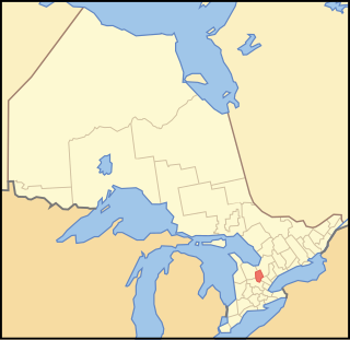
Dufferin County is a county and census division located in Central Ontario, Canada. The county seat is Orangeville, and the current Warden is Wade Mills. The current chief administrative officer is Sonya Pritchard. Dufferin covers an area of 1,486.31 square kilometres (573.87 sq mi), and its population was 61,735 at the time of the 2016 Census.
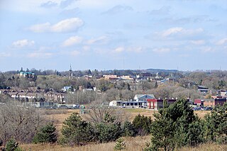
Orangeville is a town in south-central Ontario, Canada, and the seat of Dufferin County.

Bolton is an unincorporated town that is the most populous community in the town of Caledon, Ontario, Canada, in the Regional Municipality of Peel. It is located beside the Humber River, approximately 50 kilometres northwest of Toronto. In regional documents, it is referred to as a 'Rural Service Centre'. It has 26,795 residents in 9,158 total dwellings. The downtown area that historically defined the village is in a valley, through which flows the Humber River. The village extends on either side of the valley to the north and south.

The Orangeville-Brampton Railway was a 55-kilometre (34-mile) long short line railway between Orangeville and Streetsville Junction in Mississauga, Ontario. It passed through the City of Brampton and the Town of Caledon.
Erindale is an historical neighbourhood located within the central part of the city of Mississauga, west of Toronto, Ontario, Canada. Erindale is named in honour of the birthplace of the first rector of the village, Reverend James Magrath from Erin (Ireland).
Transit Windsor provides public transportation in the city of Windsor, Ontario, Canada as well as LaSalle, Essex, Kingsville, Amherstburg and Leamington and serves more than 6 million passengers each year, covering an area of 310 km2 (120 sq mi) and a population of 235,000. They operate a cross border service between the downtown areas of Windsor and Detroit, Michigan via the Tunnel Bus, and service to events at Detroit's Comerica Park, Little Caesars Arena, Huntington Place, and Ford Field. The Windsor International Transit Terminal neighbours with the Windsor International Aquatic and Training Centre.
The Hamilton, Grimsby and Beamsville Electric Railway (HG&B) was an interurban railway that operated between Hamilton and Vineland in the Niagara Peninsula in Ontario, Canada. It was incorporated in 1894.
King's Highway 136, commonly referred to as Highway 136, was a provincially maintained highway in the Canadian province of Ontario that connected former Highway 24 near Caledon with Highway 9 in Orangeville. The majority of the route was located in the Regional Municipality of Peel; however, the section in Orangeville was in Dufferin County. The route of Highway 136 was originally part of Highway 24; it was created in 1962 when Highway 24 was rerouted along Highway 51. The highway remained unchanged until 1997, when it was transferred to the Regional Municipality of Peel and the Town of Orangeville.

Eugenia is a small community in the municipality of Grey Highlands, Grey County, in Southwestern Ontario, Canada, located just north of the community of Flesherton. An unincorporated hamlet of Artemesia Township for most of its history, Eugenia was amalgamated into the Grey Highlands in 2001. Due to nearby Lake Eugenia, Eugenia Falls, the Bruce Trail and the ski resorts of the Beaver Valley, it has become a popular tourist and cottage destination. The nearby Eugenia Power Station has the highest head of water of any hydroelectric generator in Ontario, and has provided a significant amount of electricity to the provincial grid for a century.

Forks of the Credit Provincial Park, located in Caledon, Ontario, Canada, is part of the Ontario Parks system and is part of the Niagara Escarpment biosphere. The park is on the Bruce Trail. The Credit River runs through the park. Other notable features of the park include a kettle lake and talus slope.

Tullamore is a semi-rural community on the boundary of Brampton and Caledon in Ontario, Canada. It was named after the settlers who arrived from the Irish village of 'Tullymore' in County Sligo. The community is centred on the intersection of Airport Road and Mayfield Road. It had a population of 6 in 2006. Many of the original Irish settlers gravesites can be found in St. Mary's Cemetery.

The Credit Valley Railway was a railway located in Ontario, Canada from Toronto to St. Thomas. Chartered in 1871 by Ontario railway magnate George Laidlaw, it operated as an independent company until 1883 when it was leased by the Ontario and Quebec Railway, a Canadian Pacific Railway (CPR) operating company building a network of lines in southern Ontario.

Alton is a community located in Caledon, Ontario. It is also part of the Peel Region. It was established in 1820. Alton has a population of 1 116 people.

Belfountain is a community located within the borders of the town of Caledon, in Peel Region, Ontario, Canada.

Caledon Village is an unincorporated community located within the largely rural Town of Caledon in Ontario, Canada. It has a population of 1 909 people.

Brimstone, also known locally as Brimstone Point, is a small hamlet located within the town of Caledon in the Peel Region of Ontario, Canada. The population was 53 people in the 2006 census.

