Catskill Mountain House

Last updated
View from The Mountain House (1836), by William Henry Bartlett Catskill Mountain House.jpg
View from The Mountain House (1836), by William Henry Bartlett
The Mountain House (1856), by Jasper Francis Cropsey Catskill Mountain House-Cropsey.jpg
The Mountain House (1856), by Jasper Francis Cropsey
Thomas Cole - A View of the Two Lakes and Mountain House, Catskill Mountains, Morning - Brooklyn Museum Thomas Cole - A View of the Two Lakes and Mountain House, Catskill Mountains, Morning (1844) - Google Art Project.jpg
Thomas Cole - A View of the Two Lakes and Mountain House, Catskill Mountains, Morning - Brooklyn Museum

The Catskill Mountain House, which opened in 1824, was a famous hotel near Palenville, New York, and in the Catskill Mountains overlooking the Hudson River Valley. In its prime, from the 1850s to the turn of the century, it was visited by three U.S. presidents (U.S. Grant, Chester A. Arthur, and Theodore Roosevelt) and the power elite of the day.

Contents

History

Construction

The Mountain House's site, the "Pine Orchard," had long been famous for its panoramic views up and down the Hudson Valley and even beyond to the east. John Bartram and James Fenimore Cooper had both written about it, in different contexts.

Artists and writers had discovered the Catskills some time earlier. Shortly after it was constructed, the Mountain House and its surroundings became a favorite subject for Washington Irving and artists of the new Hudson River School, most notably Thomas Cole. Cooper advised his European audience, "If you want to see the sights of America, go to see Niagara Falls, Lake George and the Catskill Mountain House." [1] Harriet Martineau was more moved by the view there than at Niagara. [2]

The hotel was built in 1823 and opened a year later by a group of merchants from nearby Catskill on a plateau with sweeping views of the Hudson Valley on one side and two lakes on the other side that provided water and recreation. In 1839, Charles L. Beach, [3] whose father ran a stagecoach line from the town of Catskill to the Mountain House, leased the hotel from the owners for six years and then bought it outright. Beach rebuilt the Mountain House, changing the original Federal design into a neo-classical structure.

The Fried Chicken War

Postcard view of the hotel, undated CatskillMountainHousePostcard.jpg
Postcard view of the hotel, undated

One summer day in 1880, a prominent Philadelphia businessman and longtime Mountain House guest named George Harding asked a waiter to bring some fried chicken to his daughter Emily instead of the hotel's usual dinner fare of roast beef, as she had been prescribed a diet which excluded red meat. The ensuing argument went all the way to Beach, who refused to budge despite Harding's history with the hotel.

In exasperation, Beach suggested that Harding should perhaps build his own hotel. Harding called the bluff, checking his family out that very day and beginning plans for his own hotel, to be located atop neighboring South Mountain and utterly dwarf Beach's. He kept his word, opening the Kaaterskill Hotel next year and offering the Mountain House its first real competition.

The rivalry between the two hotels and their proprietors came to be known in the region as the "Fried Chicken War." It actually benefited both, since guests at one would often stroll to the other for lunch.

The view that made the Mountain House famous came at a cost getting up the 1,600-foot (487.6 m) climb from the valley required a five-hour stagecoach ride. As more competing hotels that were easier to reach began to be developed, the Mountain House built the cable-operated Otis Elevating Railway to bring its guests directly from the Hudson to the hotel . But the railway proved to be expensive to operate, and was finally sold for scrap in 1918 during World War I.

Decline

Undated postcard (c. 1915-1920) CatskillMountainHouseSecondPostcardC1915to1929.jpg
Undated postcard (c. 1915–1920)

Beach's promotional claim that the Mountain House sat amid the highest peaks in the Catskills suffered a major blow in the 1880s, when Princeton University geologist Arnold Henry Guyot undertook the first-ever comprehensive survey of the Catskills and found that the highest peak in the region was not Kaaterskill High Peak, which dominates the view south from higher mountains in the area, but Slide Mountain, many miles to the southwest in the Ulster County town of Shandaken.

Beach, who had long claimed that the Pine Orchard was at 3,000 feet (914.4 m) above sea level, 750 feet (228.6 m) higher than its actual elevation (a fib perpetuated even today by the state historical marker at the site), joined forces with his rivals to cast doubt on Guyot's claim, and even questioned his scientific credentials. But by 1886, other surveyors had confirmed Guyot's results, and the North-South Lake area was no longer the heart of the Catskills.

Fall

The decaying Mountain House in 1953, during an unsuccessful attempt to renovate the hotel - Image courtesy of http://www.catskillarchive.com Mtn house 1953.jpg
The decaying Mountain House in 1953, during an unsuccessful attempt to renovate the hotel - Image courtesy of http://www.catskillarchive.com

Beach and Harding both died in 1902. Just as the fame of the Mountain House was to be eclipsed by other area hotels, so were the Catskills eclipsed by the Adirondacks as the fashionable playground of the wealthy. The Mountain House continued to operate until the start of World War II 1941 was its last season.

In 1962, the State of New York acquired the property. Preservationists pointed to the hotel's historic value, but were ultimately unsuccessful when it was burned by the state Conservation Department on January 25, 1963, in accordance with revisionist Forest Preserve management policies forbidding most structures on land retroactively decreed by government to be "forever wild."

Today

View from the site of the Mountain House, 2004 Catskill Mt House View.jpg
View from the site of the Mountain House, 2004

The state now operates a large public campground, North-South Lake, near the site of the hotel. The Mountain House site is an easy walk from it along the popular Escarpment Trail.

All that remains of what was once America's most fashionable resort are the gateposts and the sweeping views from the cleared site.

See also

Related Research Articles

<span class="mw-page-title-main">Catskill Mountains</span> Mountains in southeastern New York State, U.S.

The Catskill Mountains, also known as the Catskills, are a physiographic province and subrange of the larger Appalachian Mountains, located in southeastern New York. As a cultural and geographic region, the Catskills are generally defined as those areas close to or within the borders of the Catskill Park, a 700,000-acre (2,800 km2) forest preserve protected from many forms of development under New York state law.

A kill is a body of water, most commonly a creek, but also a tidal inlet, river, strait, or arm of the sea. The term is derived from the Middle Dutch kille, meaning "riverbed" or "water channel". It is found in areas of Dutch influence in the Netherlands' former North American colony of New Netherland, primarily the Hudson and Delaware Valleys.

<span class="mw-page-title-main">Hunter Mountain (New York)</span> Highest mountain in Greene County, New York, and second highest in the Catskills

Hunter Mountain is in the towns of Hunter and Lexington, just south of the village of Hunter, in Greene County, New York, United States. At approximately 4,040 feet (1,231 m) in elevation, it is the highest peak in the county and the second-highest peak in the Catskill Mountains.

The Ulster and Delaware Railroad (U&D) was a railroad located in the state of New York. It was often advertised as "The Only All-Rail Route to the Catskill Mountains." At its greatest extent, the U&D extended 107 miles (172 km) from Kingston Point on the Hudson River through the Catskill Mountains to its western terminus at Oneonta, passing through the counties of Ulster, Delaware, Schoharie and Otsego.

<span class="mw-page-title-main">Long Path</span> Hiking trail from George Washington Bridge to Mohawk River valley in upstate New York

The Long Path is a 357-mile (575 km) long-distance hiking trail beginning in New York City, at the West 175th Street subway station near the George Washington Bridge and ending at Altamont, New York, in the Albany area. While not yet a continuous trail, relying on road walks in some areas, it nevertheless takes in many of the popular hiking attractions west of the Hudson River, such as the New Jersey Palisades, Harriman State Park, the Shawangunk Ridge and the Catskill Mountains. It offers hikers a diversity of environments to pass through, from suburbia and sea-level salt marshes along the Hudson to wilderness and boreal forest on Catskill summits 4,000 feet (1,220 m) in elevation.

<span class="mw-page-title-main">North Mountain (Catskills)</span> Mountain in New York, United States

North Mountain is a peak in the Catskill Mountains of New York, on the border between the towns of Catskill and Hunter, in Greene County. It is part of the Catskill Escarpment. Cairo Round Top is located northeast and Artists Rock is located southeast of North Mountain.

<span class="mw-page-title-main">North–South Lake</span>

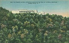
North–South Lake is an 1,100-acre (4.4 km2) state campground in the Catskill Forest Preserve near Palenville, New York operated by the New York State Department of Environmental Conservation near the site of the historic Catskill Mountain House overlooking the Hudson River. The escarpment on which the lakes are located is at 2,250 feet, 1,700 feet above the valley floor, providing a view of five states in clear weather.

<span class="mw-page-title-main">Slide Mountain (Ulster County, New York)</span> Highest peak of New Yorks Catskill Mountains

Slide Mountain is the highest peak in the Catskill Mountains of the U.S. state of New York. It is located in the town of Shandaken in Ulster County. While the 4,180-foot (1,270 m) contour line on topographic maps is generally accepted as its height, the exact elevation of the summit has never been officially determined by the U.S. National Geodetic Survey or its predecessors, and many informal surveys suggest the mountain may actually top 4,200 feet (1,280 m) above sea level.

<span class="mw-page-title-main">Otis Elevating Railway</span> Narrow gauge cable funicular railroad

The Otis Elevating Railway was a 3 ft narrow gauge cable funicular railroad leading to the Catskill Mountain House in Palenville, New York. For the first 64 years of its existence, the Catskill Mountain House was accessible only by a long stagecoach from Catskill Landing on the Hudson. Faced with increased competition from the Hotel Kaaterskill, Charles Beach hired the Otis Elevator Company to build a cable funicular railroad straight up the Great Wall of Manitou. Opening on August 7, 1892, the line measured 7,000 ft (2,134 m) long with a rise of 1,630 ft (497 m), a maximum grade of 34%, and an average grade of 12%. In 1904, the line was shortened and the lower trestle eliminated.

<span class="mw-page-title-main">Platte Clove</span> Valley in New York State, USA

Platte Clove, sometimes Plattekill Clove, is a narrow and steep valley in the Catskill Mountains of New York.

<span class="mw-page-title-main">Kaaterskill High Peak</span> Mountain in United States of America

Kaaterskill High Peak is one of the Catskill Mountains, located in the Town of Hunter in Greene County, New York, United States. It was once believed to be the highest peak in the entire range, but its summit, at 3,655 feet (1,114 m) in elevation, places it only 23rd among the Catskill High Peaks. It is, however, the fourth most prominent peak in the range. Due to its situation as the easternmost High Peak, its summit is just outside the watersheds of New York City's reservoirs in the region.

<span class="mw-page-title-main">Kaaterskill Falls</span> Waterfall in New York, United States

Kaaterskill Falls is a two-stage waterfall on Spruce Creek in the eastern Catskill Mountains of New York, between the hamlets of Haines Falls and Palenville in Greene County. The two cascades total 260 feet in height, making Kaaterskill Falls one of the highest waterfalls in New York, and one of the Eastern United States' tallest waterfalls.

<span class="mw-page-title-main">New York State Route 23A</span> State highway in Greene County, New York, US

New York State Route 23A (NY 23A) is an east–west state highway in Greene County, New York, in the United States. It serves as a 34.56-mile (55.62 km) alternate route of NY 23 through the northern Catskill Mountains. The route passes several of the Catskill High Peaks, including Hunter Mountain, before dropping into the Hudson Valley via Kaaterskill Clove and ending at an intersection with U.S. Route 9W (US 9W) in the village of Catskill. NY 23A was assigned in the mid-1920s and has not been changed since. A portion of the route through Kaaterskill Clove was closed for several months in 2006 after landslides triggered by heavy rains damaged the route.

<span class="mw-page-title-main">Catskill Mountain Railway</span> Railway in New York State, US (1882–1918)

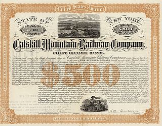
The Catskill Mountain Railway (CMRy) was a 3 ft narrow gauge railroad, 15.73 miles (25.31 km) long, running from Catskill to Palenville in Greene County, New York. Organized as the Catskill Mountain Railroad (CMRR) in 1880, it bas built in 1881 and 1882. The principals had interests in shipping on the Hudson and in hotels in the Catskill Mountains.

<span class="mw-page-title-main">Rusk Mountain</span> Mountain in New York, United States

Rusk Mountain is a peak located in the towns of Jewett and Lexington in Greene County, New York, United States. At 3,680 feet (1,120 m) in elevation, it is the 20th-highest peak in the Catskill Mountains and considered a member of the Catskill High Peaks. While there is no maintained trail, a bushwhack to the summit is considered relatively easy, and required for membership in the Catskill Mountain 3500 Club.

<span class="mw-page-title-main">Ulster & Delaware Railroad Historical Society</span>

The Ulster & Delaware Railroad Historical Society is a chapter of the National Railway Historical Society (NRHS). It focuses on the history of the railroads and related social, economic, and cultural institutions of the Catskill and Hudson Valley regions. That history, which began with the charter of the Catskill & Ithaca Railroad in 1828, encompasses numerous proposed and built railroads and trolley lines within Ulster, Delaware, Greene, Schoharie, Albany and Otsego counties.

<span class="mw-page-title-main">Catskill Escarpment</span> Mountain range in New York, U.S.

The Catskill Escarpment, often referred to locally as just the Escarpment or the Great Wall of Manitou, and known as the Catskill Front to geologists, is the range forming the northeastern corner of the Catskill Mountains in Greene and Ulster counties in the U.S. state of New York. It rises very abruptly from the Hudson Valley to summits above 3,000 feet (910 m) in elevation, including three of the Catskill High Peaks, with almost no foothills. The plateau to the south and west averages 2,000 feet (610 m) above sea level.

<span class="mw-page-title-main">Kaaterskill Clove</span> Valley in New York State, USA

Kaaterskill Clove is a deep gorge, or valley, in New York's eastern Catskill Mountains, lying just west of the village of Palenville and in Haines Falls. The clove was formed by Kaaterskill Creek, a tributary of Catskill Creek rising west of North Mountain, and is estimated by geologists to be as much as 1 million years old. Kaaterskill High Peak and Roundtop Mountain rise to the south of the gorge, while South Mountain is to its north. This makes the gorge as deep as 2,500 feet in places.

<span class="mw-page-title-main">Haines Falls, New York</span> Hamlet in New York, United States

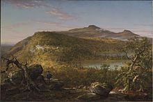
Haines Falls is a hamlet located east of Tannersville in the Town of Hunter, in Greene County, New York, United States. Haines Falls is located at 42°11′45″N74°5′49″W. The hamlet of Haines Falls was always a mountain resort town, unlike Hunter and Palenville which had tanneries. Haines Falls is at the head of Kaaterskill Clove and is the former site of the Catskill Mountain House, Kaaterskill Hotel, and Laurel House which sat atop the famous Kaaterskill Falls. In 1825, Thomas Cole, founder of the Hudson River School of landscape painters, did his first Catskill mountain paintings in Haines Falls: Lake with Dead Trees at South Lake and the Kaaterskill Falls.

<span class="mw-page-title-main">Overlook Mountain</span> Mountain in New York, United States

Overlook Mountain is the southernmost peak of the Catskill Escarpment in the central Catskill Mountains near Woodstock, New York. The centerpiece of the 590-acre (240 ha) Overlook Mountain Wild Forest area of Catskill Park, the mountain is the site of one of the remaining five Catskill Mountain fire towers and the Overlook Mountain House, a hotel which was built at a higher elevation than any other in the range.

References

  1. Silverman, Francine (2003). The Catskills Alive!. Hunter Publishing, Inc. p. 422. ISBN   1-58843-354-4.
  2. Martineau, Harriett, Society in America, Vol. I, p.179 (New York, 1837) (retrieved Dec. 18, 2022).
  3. Van Zandt, Roland (1966). The Catskill Mountain House. Rutgers, The State University. pp. 29–30. ISBN   9780962852367. LCCN   66-18877.

42°11′42″N74°02′05″W / 42.19500°N 74.03472°W / 42.19500; -74.03472