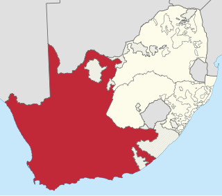
The Province of the Cape of Good Hope, commonly referred to as the Cape Province and colloquially as The Cape, was a province in the Union of South Africa and subsequently the Republic of South Africa. It encompassed the old Cape Colony, as well as Walvis Bay, and had Cape Town as its capital. In 1994, the Cape Province was divided into the new Eastern Cape, Northern Cape and Western Cape provinces, along with part of the North West.

South Africa occupies the southern tip of Africa, its coastline stretching more than 2,850 kilometres from the desert border with Namibia on the Atlantic (western) coast southwards around the tip of Africa and then northeast to the border with Mozambique on the Indian Ocean. The low-lying coastal zone is narrow for much of that distance, soon giving way to a mountainous escarpment that separates the coast from the high inland plateau. In some places, notably the province of KwaZulu-Natal in the east, a greater distance separates the coast from the escarpment. Although much of the country is classified as semi-arid, it has considerable variation in climate as well as topography. The total land area is 1,220,813 km2 (471,359 sq mi). It has the 23rd largest Exclusive Economic Zone of 1,535,538 km2 (592,875 sq mi).

KwaZulu-Natal is a province of South Africa that was created in 1994 when the Zulu bantustan of KwaZulu and Natal Province were merged. It is located in the southeast of the country, with a long shoreline on the Indian Ocean and sharing borders with three other provinces and the countries of Mozambique, Eswatini and Lesotho. Its capital is Pietermaritzburg, and its largest city is Durban. It is the second-most populous province in South Africa, with slightly fewer residents than Gauteng.

The Drakensberg is the eastern portion of the Great Escarpment, which encloses the central Southern African plateau. The Great Escarpment reaches its greatest elevation – 2,000 to 3,482 metres within the border region of South Africa and Lesotho.

The Eastern Cape is one of the provinces of South Africa. Its capital is Bhisho, but its two largest cities are East London and Gqeberha.
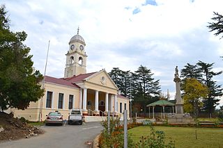
Kokstad is a town in the Harry Gwala District Municipality of KwaZulu-Natal Province, South Africa. Kokstad is named after the Griqua chief Adam Kok III who settled here in 1863. Kokstad is the capital town of the East Griqualand region, as it is also the biggest town in this region. It was built around Mount Currie, a local mountain range, by the city's founder Adam Kok III, for whom the town is named. Stad is the Dutch and Afrikaans word for "city".
Matatiele is a town located in the northern part of the Eastern Cape Province of South Africa. According to the South African National Census of 2011, its 12,466 residents and 4,107 households make Matatiele the largest populated town in the Matatiele Local Municipality.
Harrismith is a large town in the Free State province of South Africa. It was named for Sir Harry Smith, a 19th-century British governor and high commissioner of the Cape Colony. It is situated by the Wilge River, alongside the N3 highway, about midway between Johannesburg, about 300 km to the north-west, and Durban to the southeast. The town is located at the junction of the N5 highway, which continues westward towards the provincial capital Bloemfontein, some 340 km to the south-west. This important crossroads in South Africa's land trade routes is surrounded by mesas and buttes. It is located at the base of one of these called Platberg.

The R56 is a provincial route in South Africa that connects Middelburg with Pietermaritzburg via Molteno, Maclear and Kokstad. It is co-signed with the N2 between Kokstad and Stafford's Post for 39 kilometres.

The 1820 Settlers were several groups of British colonists from England, Ireland, Scotland and Wales, settled by the government of the United Kingdom and the Cape Colony authorities in the Eastern Cape of South Africa in 1820.
The CSAOne-Day Cup is the premier domestic one-day cricket competition of South Africa, its matches having List A status. Matches are usually played partly under lights as day-night matches and occasionally get larger crowds than the Test matches.
South African number plates are unique in each of the provinces. Each province has their own number plate design, colour scheme and alphanumeric scheme. e.g. AB 12 CD GP or CA 123-456
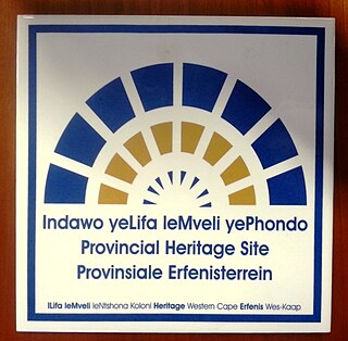
Provincial heritage sites in South Africa are places that are of historic or cultural importance within the context of the province concerned and which are for this reason declared in terms of Section 28 of the National Heritage Resources Act (NHRA) or legislation of the applicable province. The designation was a new one that came into effect with the introduction of the Act on 1 April 2000 when all former national monuments declared by the former National Monuments Council and its predecessors became provincial heritage sites as provided for in Section 58 of the Act.

The Maputaland-Pondoland-Albany Hotspot (MPA) is a biodiversity hotspot, a biogeographic region with significant levels of biodiversity, in Southern Africa. It is situated near the south-eastern coast of Africa, occupying an area between the Great Escarpment and the Indian Ocean. The area is named after Maputaland, Pondoland and Albany. It stretches from the Albany Centre of Plant Endemism in the Eastern Cape Province of South Africa, through the Pondoland Centre of Plant Endemism and KwaZulu-Natal Province, the eastern side of Eswatini and into southern Mozambique and Mpumalanga. The Maputaland Centre of Plant Endemism is contained in northern KwaZulu-Natal and southern Mozambique.

Matatiele Local Municipality is a Category B municipality located in the Alfred Nzo District of Eastern Cape in South Africa. It adjoins Lesotho to the north, Elundini to the south-west, and Greater Kokstad to the east and its 4,352 km² makes the Matatiele Local Municipality largest of four municipalities in the district at almost half of its geographical area. [1]
Umzimkhulu is a town in Harry Gwala District Municipality in the KwaZulu-Natal province of South Africa.

Griqualand East Commando was a light infantry regiment of the South African Army. It formed part of the South African Army Infantry Formation as well as the South African Territorial Reserve.

Pseudagrion draconis is a species of damselfly in the family Coenagrionidae. It is commonly known as the mountain sprite.
The marine protected areas of South Africa are in an area of coastline or ocean within the exclusive economic zone (EEZ) of the Republic of South Africa that is protected in terms of specific legislation for the benefit of the environment and the people who live in and use it. An MPA is a place where marine life can thrive under less pressure than unprotected areas. They are like underwater parks, and this healthy environment can benefit neighbouring areas.
The 2019–20 CSA Provincial T20 Cup was a domestic Twenty cricket tournament that took place in South Africa in September 2019, as a curtain-raiser to the 2019–20 South African domestic season. It was played between the thirteen South African provincial teams, along with Limpopo and Mpumalanga. This was the sixth edition of the CSA Provincial T20 Cup, which was last played in the 2015–16 season. With only domestic teams from South Africa taking part, the tournament returned in place of the Africa T20 Cup, which had been held since 2015.


