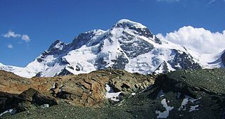
The Breithorn is a mountain range of the Pennine Alps with its highest peak of the same name, located on the border between Switzerland and Italy. It lies on the main chain of the Alps, approximately halfway between the Matterhorn and Monte Rosa and east of the Theodul Pass. Most of the massif is glaciated and includes several subsidiary peaks, all located east of the main summit: the Central Breithorn, the western Breithorn Twin, the Gendarm and the Roccia Nera. The main summit is sometimes distinguished by the name Western Breithorn. The nearest settlements are Zermatt (Valais) and St-Jacques.

Monte Rosa is a mountain massif in the eastern part of the Pennine Alps. It is between Italy's and Switzerland's (Valais). Monte Rosa is the second highest mountain in the Alps and western Europe, after Mont Blanc.
The Breithorn is a mountain located in the Pennine Alps on the border between Switzerland (Valais) and Italy.

Lyskamm, also known as Silberbast, is a mountain in the Pennine Alps lying on the border between Switzerland and Italy. It consists of a five-kilometre-long ridge with two distinct peaks. The mountain has gained a reputation for seriousness because of the many cornices lying on the ridge and the frequent avalanches, thus leading to its nickname the Menschenfresser.

The Blüemlisalp is a massif of the Bernese Alps, in the territory of the municipalities of Kandersteg and Reichenbach im Kandertal.

Castor is a mountain in the Pennine Alps on the border between Valais, Switzerland and the Aosta Valley in Italy. It is the higher of a pair of twin peaks, the other being Pollux, named after the Gemini twins of Roman mythology. Castor's peak is at an elevation of 4,223 m (13,855 ft), and it lies between Breithorn and the Monte Rosa. It is separated from Pollux by a pass at 3,847 m (12,621 ft), named Passo di Verra in Italian and Zwillingsjoch in German.

The Gornergrat is a rocky ridge of the Pennine Alps, overlooking the Gorner Glacier south-east of Zermatt in Switzerland. It can be reached from Zermatt by the Gornergrat rack railway (GGB), the highest open-air railway in Europe. Between the Gornergrat railway station and the summit is the Kulm Hotel. In the late 1960s two astronomical observatories were installed in the two towers of the Kulmhotel Gornergrat. The project “Stellarium Gornergrat” is hosted in the Gornergrat South Observatory.

The Eastern Breithorn but also referred as the western Breithorn Twin, is a peak of the Pennine Alps, located on the border between Switzerland and Italy, between the canton of Valais and the region of Aosta Valley. It is part of the Breithorn range, located east of the Theodul Pass. It lies between the Central Breithorn and its other twin, the Gendarm. On its north side it overlooks the Breithorn Glacier.
The Gendarm, but also known as eastern Breithorn Twin is a peak of the Pennine Alps, located on the border between Switzerland and Italy, between the canton of Valais and the region of Aosta Valley. It is part of the Breithorn range, located east of the Theodul Pass. It is located just east of its other twin, the western Breithorn Twin, and west of the Roccia Nera.

The Roccia Nera is a peak of the Breithorn range in the Pennine Alps, on the boundary between the Aosta Valley and canton of Valais. It is the easternmost summit of the Breithorn massif, located east of the Gendarm. It overlooks the Schwarztor pass on its east side.

The Breithorn, is a mountain of the Bernese Alps, located on the border between the Swiss cantons of Bern and Valais. It is part of the border between Lauterbrunnental and the Lötschental. It lies approximately halfway between the Tschingelhorn and the Grosshorn.

The Breithorn is a mountain of the Bernese Alps, located east of Blatten in the canton of Valais. It lies between the Bietschhorn and the Schinhorn, on the range separating the Lötschental from the main Rhone valley (south). Its summit is the tripoint between the Lötschental and two other smaller valleys: the Baltschiedertal and the valley of the Beichgletscher.

The Hübschhorn is a mountain of the Lepontine Alps, overlooking the Simplon Pass in the canton of Valais. It belongs to the Monte Leone massif. Its altitude is 3190m/10'460 ft.

The Breithorn is a mountain of the Swiss Lepontine Alps, overlooking Simplon in the canton of Valais. It is part of the Monte Leone massif.
The Wasenhorn is a mountain of the Lepontine Alps, located on the border between Switzerland and Italy. It lies halfway between Brig and Varzo, just north of Monte Leone, in the Simplon Pass area. Politically the Wasenhorn is split between the municipalities of Ried-Brig and Varzo.
The Lonzahörner are a multi-summited mountain of the Bernese Alps, located east of Blatten in the canton of Valais. They lie east of the Breithorn (Blatten), on the range between the Lötschental and the Oberaletsch Glacier.

Gobba di Rollin is a mountain of the Pennine Alps, straddling the border between Switzerland and Italy. It is located south of the Breithorn and it is largely covered by ice, the summit area being particularly flat. On the north side is the Breithorn Plateau of the Theodul Glacier, on the east side is the Verraz Glacier and on the south is the Glacier d'Aventine.

Theodul Pass, elevation 3,295 metres (10,810 ft), is a high mountain pass across the eastern Pennine Alps, connecting Zermatt in the Swiss canton of Valais and Breuil-Cervinia in the Italian region of Aosta Valley. Theodul Pass is the lowest and the easiest pass between the valleys of Zermatt and Valtournanche.
The Theodul Glacier is a glacier of the Alps, located south of Zermatt in the canton of Valais. It lies on the Swiss side of the Pennine Alps, although its upper basin touches the Italian region of the Aosta Valley. The glacier descends from the west side of the Breithorn and splits into two diverging branches above Gandegg: the Upper Theodul Glacier, spilling on a high plateau near Trockener Steg, together with the Furgg Glacier, and the Lower Theodul Glacier, reaching a height of about 2,500 metres (8,202 ft) above the Gorner Glacier. Both branches are part of the Rhone basin, through the rivers Gornera, Mattervispa, and Vispa. Slightly above the glacier splitting is the Theodul Pass, crossing the border between Switzerland and Italy, and connecting Zermatt to Breuil-Cervinia. On the west, the Theodul Glacier is overlooked by the Matterhorn.
The Breithorn Twins are twin peaks of the Breithorn range of the Pennine Alps, located on the border between Switzerland and Italy, between the canton of Valais and the region of Aosta Valley. It is located east of the Theodul Pass.

