Grasslands are areas where the vegetation is dominated by grasses (Poaceae); however, sedge (Cyperaceae) and rush (Juncaceae) families can also be found along with variable proportions of legumes, like clover, and other herbs. Grasslands occur naturally on all continents except Antarctica. Grasslands are found in most ecoregions of the Earth. For example, there are five terrestrial ecoregion classifications (subdivisions) of the temperate grasslands, savannas, and shrublands biome (ecosystem), which is one of eight terrestrial ecozones.

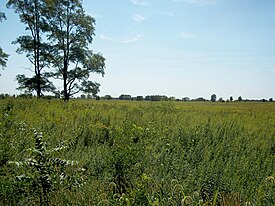
The tallgrass prairie is an ecosystem native to central North America. Natural and anthropogenic fire, as well as grazing by large mammals, were historically agents of periodic disturbance, which regulates tree encroachment, recycles nutrients to the soil, and catalyzes some seed dispersal and germination processes. Prior to widespread use of the steel plow, which enabled large scale conversion to agricultural land use, tallgrass prairies extended throughout the American Midwest and smaller portions of southern central Canada, from the transitional ecotones out of eastern North American forests, west to a climatic threshold based on precipitation and soils, to the southern reaches of the Flint Hills in Oklahoma, to a transition into forest in Manitoba.

An oak savanna is a type of savanna, or lightly forested grassland, where oaks are the dominant trees. These savannas were maintained historically through wildfires set by lightning or humans, grazing, low precipitation, and/or poor soil.

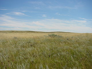
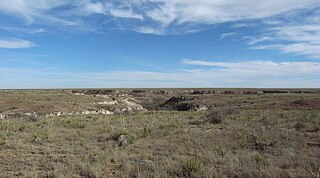
The Flint Hills, historically known as Bluestem Pastures or Blue Stem Hills, are a region in eastern Kansas and north-central Oklahoma named for the abundant residual flint eroded from the bedrock that lies near or at the surface. It consists of a band of hills stretching from Kansas to Oklahoma, extending from Marshall and Washington Counties in the north to Cowley County, Kansas and Kay and Osage Counties in Oklahoma in the south, to Geary and Shawnee Counties west to east. Oklahomans generally refer to the same geologic formation as the Osage Hills or "the Osage."

The Texas Blackland Prairies are a temperate grassland ecoregion located in Texas that runs roughly 300 miles (480 km) from the Red River in North Texas to San Antonio in the south. The prairie was named after its rich, dark soil.

The Western Gulf coastal grasslands are a subtropical grassland ecoregion of the southern United States and northeastern Mexico. It is known in Louisiana as the "Cajun Prairie", Texas as "Coastal Prairie," and as the Tamaulipan pastizal in Mexico.

The Terai-Duar savanna and grasslands is a narrow lowland ecoregion at the base of the Himalayas, about 25 km (16 mi) wide, and a continuation of the Gangetic Plain. It is colloquially called Terai in the Ganges Basin east to Nepal, then Dooars in West Bengal, Bangladesh, Bhutan and Assam east to the Brahmaputra River. The world's tallest grasslands are found in this ecoregion, which are the most threatened and rare worldwide.
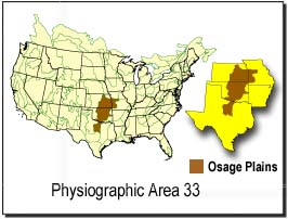
The Osage Plains are a physiographic section of the larger Central Lowland province, which in turn is part of the larger Interior Plains physiographic division. The area is sometimes called the Lower Plains, North Central Plains,or Rolling Plains. The Osage Plains, covering west-central Missouri, the southeastern third of Kansas, most of central Oklahoma, and extending into north-central Texas, is the southernmost of three tallgrass prairie physiographic areas. It grades into savanna and woodland to the east and south, and into shorter, mixed-grass prairie to the west. The Osage Plains consist of three subregions. The Osage Plains proper occupy the northeast segment. Although sharply demarcated from the Ozark uplift, the plains are nonetheless a transitional area across which the boundary between prairie and woodland has shifted over time. In the central portion of the physiographic area lies the second subregion, the Flint Hills, commonly called "the Osage" in Oklahoma. This large remnant core of native tallgrass prairie is a rocky rolling terrain that runs from north to south across Kansas and extends into Oklahoma. To the west and south of these hills are the Blackland Prairies and Cross Timbers. This vegetatively complex region of intermixed prairie and scrubby juniper-mesquite woodland extends into north-central Texas. Bluestem prairies and oak-dominated savannas and woodlands characterize the natural vegetation in the Cross Timbers. Much of the area has been converted to agriculture, although expanses of oak forest and woodland are still scattered throughout the eastern portion of the subregion.

The central U.S. hardwood forests comprise a temperate broadleaf and mixed forests ecoregion in the Eastern United States, as defined by the World Wildlife Fund. It has one of the most diverse herbaceous plant floras of ecoregions in North America.
The Tamaulipan mezquital ecoregion, in the deserts and xeric shrublands biome, is located in the southern United States and northeastern Mexico. It covers an area of 141,500 km2 (54,600 sq mi), encompassing a portion of the Gulf Coastal Plain in southern Texas, northern Tamaulipas, northeastern Coahuila, and part of Nuevo León.

The Willamette Valley ecoregion is a Level III ecoregion designated by the United States Environmental Protection Agency in the U.S. states of Oregon and Washington. Slightly larger than the Willamette Valley for which it is named, the ecoregion contains fluvial terraces and floodplains of the Willamette River system, scattered hills, buttes, and adjacent foothills. It is distinguished from the neighboring Coast Range, Cascades, and Klamath Mountains ecoregions by lower precipitation, lower elevation, less relief, and a different mosaic of vegetation. Mean annual rainfall is 37 to 60 inches, and summers are generally dry. Historically, the region was covered by rolling prairies, oak savanna, coniferous forests, extensive wetlands, and deciduous riparian forests. Today, it contains the bulk of Oregon's population, industry, commerce, and agriculture. Productive soils and a temperate climate make it one of the most important agricultural areas in Oregon.

The Ozark Highlands is a Level III ecoregion designated by the Environmental Protection Agency (EPA) in four U.S. states. Most of the region is within Missouri, with a part in Arkansas and small sections in Oklahoma and Kansas. It is the largest subdivision of the region known as the Ozark Mountains, flatter in comparison to the Boston Mountains in Arkansas, the steepest part of the Ozarks.

The Upper Midwest forest-savanna transition is a terrestrial ecoregion that is defined by the World Wildlife Fund. An oak savanna plant community located in the Upper Midwest region of the United States, it is an ecotone between the tallgrass prairies to the west and the temperate deciduous forests to the east. A part of the Upper Mississippi River basin, it is considered endangered with less than 5% of the original ecosystem remaining intact, due mostly to overgrazing and conversion to agriculture.
The Northern short grasslands is one of 867 terrestrial ecoregions defined by the World Wide Fund for Nature. This ecoregion includes parts of the Canadian provinces of Alberta and Saskatchewan, and the American Great Plains states of Montana, North Dakota, Wyoming, South Dakota and Nebraska. The United States Environmental Protection Agency (EPA) further breaks this ecoregion into the Northwestern Glaciated Plains and Northwestern Great Plains.
The Western short grasslands is a temperate grassland ecoregion of the United States.

The Wyoming Basin shrub steppe ecoregion, within the deserts and xeric shrublands biome, is a shrub steppe in the northwestern United States.

The Central tall grasslands are a prairie ecoregion of the Midwestern United States, part of the North American Great Plains.
The Interior Low Plateaus are a physiographic region in eastern United States. It consists of a diverse landscape that extends from north Alabama across central Tennessee and Kentucky into southern Illinois, Indiana, and Ohio. Its natural communities are a matrix of temperate forests, woodlands, and prairies.

The Central Great Plains are a semi-arid prairie ecoregion of the central United States, part of North American Great Plains. The region runs from west-central Texas through west-central Oklahoma, central Kansas, and south-central Nebraska.

The Northern Mixed Grasslands is one of 867 terrestrial ecoregions defined by the World Wide Fund for Nature. This ecoregion includes parts of the Canadian provinces of Saskatchewan and Manitoba, north-central and eastern North Dakota, most of east South Dakota, and small portions of western Minnesota in the American Great Plains. The United States Environmental Protection Agency (EPA) defines this ecoregion as the Northern Glaciated Plains.