The Northeastern coastal forests are a temperate broadleaf and mixed forests ecoregion of the northeast and middle Atlantic region of the United States. The ecoregion covers an area of 34,630 sq miles (89,691 km²) encompassing the Piedmont and coastal plain of seven states, extending from coastal southwestern Maine, southeastern New Hampshire, eastern Massachusetts, and Rhode Island, southward through Connecticut, New York State, New Jersey, southeast Pennsylvania, Delaware and Maryland.

The tallgrass prairie is an ecosystem native to central North America. Natural and anthropogenic fire, as well as grazing by large mammals, were historically agents of periodic disturbance, which regulates tree encroachment, recycles nutrients to the soil, and catalyzes some seed dispersal and germination processes. Prior to widespread use of the steel plow, which enabled large scale conversion to agricultural land use, tallgrass prairies extended throughout the American Midwest and smaller portions of southern central Canada, from the transitional ecotones out of eastern North American forests, west to a climatic threshold based on precipitation and soils, to the southern reaches of the Flint Hills in Oklahoma, to a transition into forest in Manitoba.

An oak savanna is a type of savanna, or lightly forested grassland, where oaks are the dominant trees. These savannas were maintained historically through wildfires set by lightning or humans, grazing, low precipitation, and/or poor soil.

The Driftless Area is a region in southwestern Wisconsin, southeastern Minnesota, northeastern Iowa, and the extreme northwestern corner of Illinois, of the American Midwest. The region escaped the flattening effects of glaciation during the last ice age and is consequently characterized by steep, forested ridges, deeply carved river valleys, and karst geology characterized by spring-fed waterfalls and cold-water trout streams. Ecologically, the Driftless Area's flora and fauna are more closely related to those of the Great Lakes region and New England than those of the broader Midwest and central Plains regions. Colloquially, the term includes the incised Paleozoic Plateau of southeastern Minnesota and northeastern Iowa. The region includes elevations ranging from 603 to 1,719 feet at Blue Mound State Park and covers 24,000 square miles (62,200 km2). The rugged terrain is due both to the lack of glacial deposits, or drift, and to the incision of the upper Mississippi River and its tributaries into bedrock.
Aspen parkland refers to a very large area of transitional biome between prairie and boreal forest in two sections, namely the Peace River Country of northwestern Alberta crossing the border into British Columbia, and a much larger area stretching from central Alberta, all across central Saskatchewan to south central Manitoba and continuing into small parts of the US states of Minnesota and North Dakota. Aspen parkland consists of groves of aspen poplars and spruce interspersed with areas of prairie grasslands, also intersected by large stream and river valleys lined with aspen-spruce forests and dense shrubbery. This is the largest boreal-grassland transition zone in the world and is a zone of constant competition and tension as prairie and woodlands struggle to overtake each other within the parkland.

The Texas Blackland Prairies are a temperate grassland ecoregion located in Texas that runs roughly 300 miles (480 km) from the Red River in North Texas to San Antonio in the south. The prairie was named after its rich, dark soil.

The Western Gulf coastal grasslands are a subtropical grassland ecoregion of the southern United States and northeastern Mexico. It is known in Louisiana as the "Cajun Prairie", Texas as "Coastal Prairie," and as the Tamaulipan pastizal in Mexico.

The central U.S. hardwood forests comprise a temperate broadleaf and mixed forests ecoregion in the Eastern United States, as defined by the World Wildlife Fund. It has one of the most diverse herbaceous plant floras of ecoregions in North America.

The Willamette Valley ecoregion is a Level III ecoregion designated by the United States Environmental Protection Agency in the U.S. states of Oregon and Washington. Slightly larger than the Willamette Valley for which it is named, the ecoregion contains fluvial terraces and floodplains of the Willamette River system, scattered hills, buttes, and adjacent foothills. It is distinguished from the neighboring Coast Range, Cascades, and Klamath Mountains ecoregions by lower precipitation, lower elevation, less relief, and a different mosaic of vegetation. Mean annual rainfall is 37 to 60 inches, and summers are generally dry. Historically, the region was covered by rolling prairies, oak savanna, coniferous forests, extensive wetlands, and deciduous riparian forests. Today, it contains the bulk of Oregon's population, industry, commerce, and agriculture. Productive soils and a temperate climate make it one of the most important agricultural areas in Oregon.

Pre-Columbian savannas once existed across North America. These were created by both natural lightning fires and by Native Americans. The arrival of European settlers caused the death of most Native Americans in the 16th century. Surviving natives continued using fire to clear savanna until European colonists began colonizing the eastern seaboard two hundred years later. Many colonists continued the practice of burning to clear underbrush, reinforced by their similar experience in Europe, but some land reverted to forest.

The Central forest-grasslands transition is a prairie ecoregion of the central United States, an ecotone between eastern forests and the North American Great Plains. It is a classification defined by the World Wildlife Fund.

The Central tall grasslands are a prairie ecoregion of the Midwestern United States, part of the North American Great Plains.

The Middle Atlantic coastal forests are a temperate coniferous forest mixed with patches of evergreen broadleaved forests along the coast of the southeastern United States.
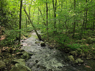
The Interior Low Plateaus are a physiographic region in eastern United States. It consists of a diverse landscape that extends from north Alabama across central Tennessee and Kentucky into southern Illinois, Indiana, and Ohio. Its natural communities are a matrix of temperate forests, woodlands, and prairies.

The Western Great Lakes forests is a terrestrial ecoregion as defined by the World Wildlife Fund. It is within the Temperate Broadleaf and Mixed Forests ecozone of North America, in the United States' states of Michigan, Wisconsin and Minnesota, and the Canadian provinces of Ontario and Manitoba.

The Central Great Plains are a semi-arid prairie ecoregion of the central United States, part of North American Great Plains. The region runs from west-central Texas through west-central Oklahoma, central Kansas, and south-central Nebraska.

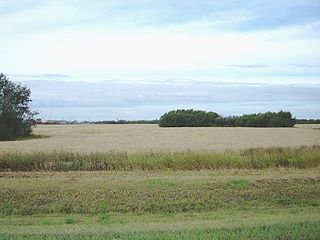
The Northern Mixed Grasslands is one of 867 terrestrial ecoregions defined by the World Wide Fund for Nature. This ecoregion includes parts of the Canadian provinces of Saskatchewan and Manitoba, north-central and eastern North Dakota, most of east South Dakota, and small portions of western Minnesota in the American Great Plains. The United States Environmental Protection Agency (EPA) defines this ecoregion as the Northern Glaciated Plains.
The North Central Hardwood Forests are a temperate broadleaf and mixed forests ecoregion in central Minnesota, central Wisconsin, and northwestern Lower Michigan, embedded between (clockwise) the Western Corn Belt Plains in the south, the Northern Glaciated Plains, the Red River Valley, the Northern Minnesota Wetlands, and the Northern Lakes and Forests. It forms the northern part of the upper Midwest forest-savanna transition, which also includes regions 52 and 53.

