Centropolis, Kansas

Last updated

Centropolis, Kansas
CDP
Map of Franklin Co, Ks, USA.png
USA Kansas location map.svg
Red pog.svg
Centropolis
Usa edcp location map.svg
Red pog.svg
Centropolis
Coordinates: 38°42′58″N95°21′01″W / 38.71611°N 95.35028°W / 38.71611; -95.35028 [1]
Country United States
State Kansas
County Franklin
Elevation
[1]
961 ft (293 m)
Population
 (2020) [2]
  Total100
Time zone UTC-6 (CST)
  Summer (DST) UTC-5 (CDT)
Area code 785
FIPS code 20-12450 [1]
GNIS ID 479371 [1]

Centropolis is a census-designated place (CDP) in Franklin County, Kansas, United States. [1] As of the 2020 census, the population was 100. [2] It is located about 11 miles northwest of Ottawa. In the 1850s, Centropolis had the distinction of briefly vying for territorial capital of Kansas.

Contents

History

The area was first settled by Perry Fuller in 1855 who established a store in order to trade with the nearby Ottawa Indians. His store prospered and in 1856 he established the Centropolis Town Company and began selling lots. [3] The community name is a portmanteau of central and metropolis. A missionary newspaper published by Jotham Meeker for the Ottawa Baptist Mission was the first newspaper in Franklin County. The first commercial newspaper in the County, the Kansas Leader, was founded in 1857[ citation needed ]. Not only did Fuller expect his new town to become county seat but also the territorial capital of Kansas and eventually state capital. [4]

Just a couple miles east of Centropolis, St. Bernard was established and the Territorial Legislature made St. Bernard the Franklin County seat [5] but despite having the county seat, St. Bernard did not grow and post office was closed and renamed Minneola.

The Centropolis post office closed in 1930. [6]

Geography

Centropolis has an elevation of 961 feet (293 m). [1]

Demographics

Historical population
CensusPop.Note
2020 100
U.S. Decennial Census

The 2020 United States census counted 100 people, 50 households, and 31 families in Centropolis. [7] [8] The population density was 298.5 per square mile (115.3/km2). There were 51 housing units at an average density of 152.2 per square mile (58.8/km2). [8] [9] The racial makeup was 88.0% (88) white or European American (88.0% non-Hispanic white), 0.0% (0) black or African-American, 1.0% (1) Native American or Alaska Native, 0.0% (0) Asian, 0.0% (0) Pacific Islander or Native Hawaiian, 5.0% (5) from other races, and 6.0% (6) from two or more races. [10] Hispanic or Latino of any race was 6.0% (6) of the population. [11]

Of the 50 households, 18.0% had children under the age of 18; 42.0% were married couples living together; 26.0% had a female householder with no spouse or partner present. 34.0% of households consisted of individuals and 12.0% had someone living alone who was 65 years of age or older. [8] The average household size was 2.6 and the average family size was 2.3. [12] The percent of those with a bachelor’s degree or higher was estimated to be 0.0% of the population. [13]

23.0% of the population was under the age of 18, 6.0% from 18 to 24, 18.0% from 25 to 44, 35.0% from 45 to 64, and 18.0% who were 65 years of age or older. The median age was 49.0 years. For every 100 females, there were 85.2 males. [8] For every 100 females ages 18 and older, there were 87.8 males. [8]

Related Research Articles

<span class="mw-page-title-main">Franklin County, Kansas</span> County in Kansas, United States

Franklin County is a county located in the eastern portion of the U.S. state of Kansas. Its county seat and most populous city is Ottawa. As of the 2020 census, the county population was 25,996. The county was named for Benjamin Franklin, a founding father of the United States. Formerly it was considered part of the Kansas City metropolitan area, but was removed in 2013.

<span class="mw-page-title-main">Harris, Kansas</span> Unincorporated community in Anderson County, Kansas

Harris is a census-designated place (CDP) in Anderson County, Kansas, United States. As of the 2020 census, the population was 47.

<span class="mw-page-title-main">Lecompton, Kansas</span> City in Kansas, United States

Lecompton is a city in Douglas County, Kansas, United States. As of the 2020 census, the population of the city was 588. Lecompton was the de jure territorial capital of Kansas from 1855 to 1861, and the Douglas County seat from 1855 to 1858. Anti-slavery Lawrence became the de facto capital during the latter part of this period, when the county seat was moved there. This time period was known as Bleeding Kansas, due to the violence perpetrated by the pro-slavery, and to a lesser extent the anti-slavery, factions in the eastern part of the state. Lecompton was a hotbed of pro-slavery sentiment during the mid-1800s.

<span class="mw-page-title-main">Lane, Kansas</span> City in Franklin County, Kansas

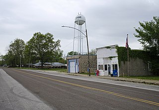
Lane is a city in Franklin County, Kansas, United States. As of the 2020 census, the population of the city was 241.

<span class="mw-page-title-main">Ottawa, Kansas</span> City in Franklin County, Kansas

Ottawa is a city in, and the county seat of, Franklin County, Kansas, United States. It is located on both banks of the Marais des Cygnes River near the center of Franklin County. As of the 2020 census, the population of the city was 12,625. It is the home of Ottawa University.

<span class="mw-page-title-main">Pomona, Kansas</span> City in Franklin County, Kansas

Pomona is a city in Franklin County, Kansas, United States. As of the 2020 census, the population of the city was 884.

<span class="mw-page-title-main">Princeton, Kansas</span> City in Franklin County, Kansas

Princeton is a city in Franklin County, Kansas, United States. As of the 2020 census, the population of the city was 248.

<span class="mw-page-title-main">Delphos, Kansas</span> City in Ottawa County, Kansas

Delphos is a city in Ottawa County, Kansas, United States. As of the 2020 census, the population of the city was 302. The community was named after Delphos, Ohio.

<span class="mw-page-title-main">Minneapolis, Kansas</span> City in Ottawa County, Kansas

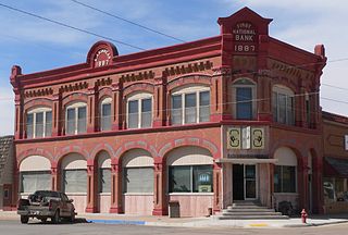
Minneapolis is a city in and the county seat of Ottawa County, Kansas, United States. As of the 2020 census, the population of the city was 1,946.

<span class="mw-page-title-main">Atwood, Kansas</span> City in Rawlins County, Kansas

Atwood is a city in and the county seat of Rawlins County, Kansas, United States. As of the 2020 census, the population of the city was 1,290.

<span class="mw-page-title-main">Andale, Kansas</span> City in Sedgwick County, Kansas

Andale is a city in Sedgwick County, Kansas, United States. As of the 2020 census, the population of the city was 941.

<span class="mw-page-title-main">Alma, Kansas</span> City in Wabaunsee County, Kansas

Alma is a city in and the county seat of Wabaunsee County, Kansas, United States. As of the 2020 census, the population of the city was 802.

<span class="mw-page-title-main">Chicopee, Kansas</span> Unincorporated community in Crawford County, Kansas

Chicopee is a census-designated place (CDP) in Crawford County, Kansas, United States. As of the 2020 census, the population was 422.

<span class="mw-page-title-main">Beaver, Kansas</span> Unincorporated community in Barton County, Kansas

Beaver is a census-designated place (CDP) in Beaver Township, Barton County, Kansas, United States. As of the 2020 census, the population was 52. It is located northeast of Hoisington at the intersection of NE 190 Rd and NE 60 Ave.

<span class="mw-page-title-main">Bridgeport, Kansas</span> Unincorporated community in Saline County, Kansas

Bridgeport is a census-designated place (CDP) in Smoky View Township, Saline County, Kansas, United States. As of the 2020 census, the population was 64. It is located south of Salina, along K-4 near Interstate 135.

<span class="mw-page-title-main">Crestline, Kansas</span> Unincorporated community in Cherokee County, Kansas

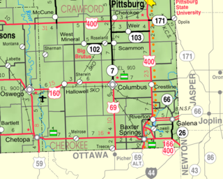
Crestline is a census-designated place (CDP) in Cherokee County, Kansas, United States. As of the 2020 census, the population was 116. Crestline is located on U.S. Route 400 7.5 miles (12.1 km) east of Columbus. Crestline has a post office with ZIP code 66728.

<span class="mw-page-title-main">Kickapoo Site 1, Kansas</span> Unincorporated community in Brown County, Kansas

Kickapoo Site 1 is a census-designated place (CDP) in Brown County, Kansas, United States, on the Kickapoo Indian Reservation. As of the 2020 census, the population was 110.

<span class="mw-page-title-main">Ada, Kansas</span> Unincorporated community in Ottawa County, Kansas

Ada is a census-designated place (CDP) in Ottawa County, Kansas, United States. As of the 2020 census, the population was 86. It is located approximately 12 miles west of Minneapolis.

<span class="mw-page-title-main">Niles, Kansas</span> Unincorporated community in Ottawa County, Kansas

Niles is a census-designated place (CDP) in Ottawa County, Kansas, United States. As of the 2020 census, the population was 56.

Hopkinton is a census-designated place (CDP) in Washington County, Rhode Island, United States, comprising the central village in the town of Hopkinton. It was first listed as a CDP prior to the 2020 census. The village is also known as Hopkinton City, and the center of the village comprises the Hopkinton City Historic District.

References

  1. 1 2 3 4 5 6 "Centropolis, Kansas", Geographic Names Information System , United States Geological Survey, United States Department of the Interior
  2. 1 2 "Profile of Centropolis, Kansas (CDP) in 2020". United States Census Bureau. Archived from the original on June 25, 2022. Retrieved June 25, 2022.
  3. "Centropolis - KS-Cyclopedia - 1912". Archived from the original on June 7, 2013. Retrieved February 14, 2019.
  4. kancoll.com
  5. Ghost Towns of Kansas: A Traveler's Guide by Daniel Fitzgerald. University Press of Kansas. 1988.
  6. "Kansas Post Offices, 1828-1961 (archived)". Kansas Historical Society. Archived from the original on October 9, 2013. Retrieved June 10, 2014.
  7. "US Census Bureau, Table P16: HOUSEHOLD TYPE". data.census.gov. Retrieved December 31, 2023.
  8. 1 2 3 4 5 "US Census Bureau, Table DP1: PROFILE OF GENERAL POPULATION AND HOUSING CHARACTERISTICS". data.census.gov. Retrieved December 31, 2023.
  9. Bureau, US Census. "Gazetteer Files". Census.gov. Retrieved December 30, 2023.
  10. "US Census Bureau, Table P1: RACE". data.census.gov. Retrieved December 31, 2023.
  11. "US Census Bureau, Table P2: HISPANIC OR LATINO, AND NOT HISPANIC OR LATINO BY RACE". data.census.gov. Retrieved December 31, 2023.
  12. "US Census Bureau, Table S1101: HOUSEHOLDS AND FAMILIES". data.census.gov. Retrieved December 31, 2023.
  13. "US Census Bureau, Table S1501: EDUCATIONAL ATTAINMENT". data.census.gov. Retrieved December 31, 2023.

Further reading