Princeton, Kansas

Last updated

Princeton, Kansas
Franklin County Kansas Incorporated and Unincorporated areas Princeton Highlighted.svg
Location within Franklin County and Kansas
Map of Franklin Co, Ks, USA.png
Coordinates: 38°29′18″N95°16′13″W / 38.48833°N 95.27028°W / 38.48833; -95.27028 [1]
Country United States
State Kansas
County Franklin
Founded1869
Incorporated 1921
Named for Princeton, Illinois
Area
[2]
  Total0.35 sq mi (0.91 km2)
  Land0.35 sq mi (0.90 km2)
  Water0.00 sq mi (0.01 km2)
Elevation
[1]
965 ft (294 m)
Population
 (2020) [3]
  Total248
  Density710/sq mi (270/km2)
Time zone UTC-6 (CST)
  Summer (DST) UTC-5 (CDT)
ZIP code
66078
Area code 785
FIPS code 20-57725
GNIS ID 2396282 [1]

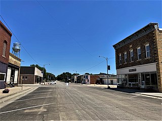
Princeton is a city in Franklin County, Kansas, United States. [1] As of the 2020 census, the population of the city was 248. [3]

Contents

History

Princeton had its start about 1869 by the building of the railroad through that territory. [4] It was named after the city of Princeton, Illinois. [5]

The railroad no longer runs through Princeton, and the former tracks have been converted into the Prairie Spirit rail trail. [6]

Geography

Princeton is located at 38°29′18″N95°16′13″W / 38.48833°N 95.27028°W / 38.48833; -95.27028 (38.488387, -95.270357). [7] According to the United States Census Bureau, the city has a total area of 0.33 square miles (0.85 km2), all of it land. [8]

Demographics

Historical population
CensusPop.Note
1880 103
1930 210
1940 187−11.0%
1950 177−5.3%
1960 174−1.7%
1970 159−8.6%
1980 24453.5%
1990 27512.7%
2000 31715.3%
2010 277−12.6%
2020 248−10.5%
U.S. Decennial Census

2010 census

As of the census [9] of 2010, there were 277 people, 109 households, and 78 families residing in the city. The population density was 839.4 inhabitants per square mile (324.1/km2). There were 121 housing units at an average density of 366.7 per square mile (141.6/km2). The racial makeup of the city was 95.3% White, 1.1% Native American, and 3.6% from two or more races. Hispanic or Latino of any race were 4.3% of the population.

There were 109 households, of which 37.6% had children under the age of 18 living with them, 53.2% were married couples living together, 14.7% had a female householder with no husband present, 3.7% had a male householder with no wife present, and 28.4% were non-families. 22.0% of all households were made up of individuals, and 6.4% had someone living alone who was 65 years of age or older. The average household size was 2.54 and the average family size was 2.97.

The median age in the city was 33.5 years. 27.4% of residents were under the age of 18; 9.1% were between the ages of 18 and 24; 25.6% were from 25 to 44; 26.7% were from 45 to 64; and 11.2% were 65 years of age or older. The gender makeup of the city was 45.8% male and 54.2% female.

2000 census

As of the census [10] of 2000, there were 317 people, 111 households, and 88 families residing in the city. The population density was 941.9 inhabitants per square mile (363.7/km2). There were 118 housing units at an average density of 350.6 per square mile (135.4/km2). The racial makeup of the city was 95.90% White, 0.63% African American, 0.63% Asian, and 2.84% from two or more races. 0.63% of the population were Hispanic or Latino of any race.

There were 111 households, out of which 45.0% had children under the age of 18 living with them, 65.8% were married couples living together, 9.9% had a female householder with no husband present, and 20.7% were non-families. 18.9% of all households were made up of individuals, and 9.0% had someone living alone who was 65 years of age or older. The average household size was 2.86 and the average family size was 3.19.

In the city, the population was spread out, with 33.4% under the age of 18, 9.5% from 18 to 24, 29.3% from 25 to 44, 18.3% from 45 to 64, and 9.5% who were 65 years of age or older. The median age was 32 years. For every 100 females, there were 109.9 males. For every 100 females age 18 and over, there were 95.4 males.

The median income for a household in the city was $33,333, and the median income for a family was $36,042. Males had a median income of $26,607 versus $20,139 for females. The per capita income for the city was $11,698. 8.5% of the population and 4.9% of families were below the poverty line. Out of the total population, 5.2% of those under the age of 18 and 23.1% of those 65 and older were living below the poverty line.

Education

Princeton is a part of Central Heights USD 288 school district, headquarters located in Richmond. School mascot is Central Heights Vikings. [11]

Princeton schools were closed through school unification in 1965. The Princeton High School mascot was Princeton Orioles. [12]

Related Research Articles

<span class="mw-page-title-main">Mildred, Kansas</span> Unincorporated community in Allen County, Kansas

Mildred is a unincorporated community in Allen County, Kansas, United States. As of the 2020 census, the population of the community and nearby areas was 25. It is located 7 miles north of Moran along US 59 highway.

<span class="mw-page-title-main">Robinson, Kansas</span> City in Brown County, Kansas

Robinson is a city in Brown County, Kansas, United States. As of the 2020 census, the population of the city was 183.

<span class="mw-page-title-main">Willis, Kansas</span> City in Brown County, Kansas

Willis is a city in Brown County, Kansas, United States. As of the 2020 census, the population of the city was 24.

<span class="mw-page-title-main">Rose Hill, Kansas</span> City in Butler County, Kansas

Rose Hill is a city in Butler County, Kansas, United States. As of the 2020 census, the population of the city was 4,185.

<span class="mw-page-title-main">West Mineral, Kansas</span> City in Cherokee County, Kansas

West Mineral is a city in Cherokee County, Kansas, United States. As of the 2020 census, the population of the city was 154. It is the home of Big Brutus, the second largest electric shovel in the world.

<span class="mw-page-title-main">Gridley, Kansas</span> City in Coffey County, Kansas

Gridley is a city in Coffey County, Kansas, United States. As of the 2020 census, the population of the city was 313.

<span class="mw-page-title-main">Troy, Kansas</span> City in Doniphan County, Kansas

Troy is a city in and the county seat of Doniphan County, Kansas, United States. As of the 2020 census, the population of the city was 964.

<span class="mw-page-title-main">Howard, Kansas</span> City in Elk County, Kansas

Howard is a city in and the county seat of Elk County, Kansas, United States. As of the 2020 census, the population of the city was 570.

<span class="mw-page-title-main">Rantoul, Kansas</span> City in Franklin County, Kansas

Rantoul is a city in Franklin County, Kansas, United States. As of the 2020 census, the population of the city was 165.

<span class="mw-page-title-main">Richmond, Kansas</span> City in Franklin County, Kansas

Richmond is a city in Franklin County, Kansas, United States. As of the 2020 census, the population of the city was 459.

<span class="mw-page-title-main">Ingalls, Kansas</span> City in Gray County, Kansas

Ingalls is a city in Gray County, Kansas, United States. As of the 2020 census, the population of the city was 252.

<span class="mw-page-title-main">Winchester, Kansas</span> City in Kansas, United States

Winchester is a city in Jefferson County, Kansas, United States. As of the 2020 census, the population of the city was 461.

<span class="mw-page-title-main">Thayer, Kansas</span> City in Neosho County, Kansas

Thayer is a city in Neosho County, Kansas, United States. As of the 2020 census, the population of the city was 432.

<span class="mw-page-title-main">Quenemo, Kansas</span> City in Osage County, Kansas

Quenemo is a city in Osage County, Kansas, United States, along the Marais des Cygnes River. As of the 2020 census, the population of the city was 288.

<span class="mw-page-title-main">Scranton, Kansas</span> City in Osage County, Kansas

Scranton is a city in Osage County, Kansas, United States. As of the 2020 census, the population of the city was 653. It was named after the city of Scranton, Pennsylvania due to its coal mining in the 19th century.

<span class="mw-page-title-main">Wheaton, Kansas</span> City in Pottawatomie County, Kansas

Wheaton is a city in Pottawatomie County, Kansas, United States. As of the 2020 census, the population of the city was 98.

<span class="mw-page-title-main">Republic, Kansas</span> City in Republic County, Kansas, United States

Republic is a city in Republic County, Kansas, United States. As of the 2020 census, the population of the city was 82.

<span class="mw-page-title-main">Brewster, Kansas</span> City in Thomas County, Kansas

Brewster is a city in Thomas County, Kansas, United States. As of the 2020 census, the population of the city was 291.

<span class="mw-page-title-main">Paxico, Kansas</span> City in Wabaunsee County, Kansas

Paxico is a city in Wabaunsee County, Kansas, United States. As of the 2020 census, the population of the city was 210.

<span class="mw-page-title-main">Buffalo, Kansas</span> City in Wilson County, Kansas

Buffalo is a city in Wilson County, Kansas, United States. As of the 2020 census, the population of the city was 217.

References

  1. 1 2 3 4 U.S. Geological Survey Geographic Names Information System: Princeton, Kansas
  2. "2019 U.S. Gazetteer Files". United States Census Bureau. Retrieved July 24, 2020.
  3. 1 2 "Profile of Princeton, Kansas in 2020". United States Census Bureau. Archived from the original on June 25, 2022. Retrieved June 25, 2022.
  4. Blackmar, Frank Wilson (1912). Kansas: A Cyclopedia of State History, Volume 2. Standard Publishing Company. pp.  505.
  5. "Profile for Princeton, Kansas". ePodunk. Archived from the original on May 14, 2019. Retrieved June 10, 2014.
  6. "Trail of the Month: August 2011; Kansas' Prairie Spirit Trail". Rails-to-Trails Conservancy. Retrieved May 9, 2014.
  7. "US Gazetteer files: 2010, 2000, and 1990". United States Census Bureau. February 12, 2011. Retrieved April 23, 2011.
  8. "US Gazetteer files 2010". United States Census Bureau. Archived from the original on January 25, 2012. Retrieved July 6, 2012.
  9. "U.S. Census website". United States Census Bureau . Retrieved July 6, 2012.
  10. "U.S. Census website". United States Census Bureau . Retrieved January 31, 2008.
  11. "Central Heights USD 288". USD 288. Retrieved January 7, 2017.
  12. "Williamsburg Cinches Tie for Franklin League Title", The Ottawa Herald, 16 February 1963, p.2.

Further reading