Chama Basin

Last updated

The Chama Basin is a small basin east of the San Juan Basin in northern New Mexico RioChamaWatershed.png
The Chama Basin is a small basin east of the San Juan Basin in northern New Mexico

The Chama Basin is a geologic structural basin located in northern New Mexico. The basin closely corresponds to the drainage basin of the Rio Chama and is located between the eastern margin of the San Juan Basin and the western margin of the Rio Grande Rift. Exposed in the basin is a thick and nearly level section of sedimentary rock of Permian to Cretaceous age, with some younger overlying volcanic rock. [1] The basin has an area of about 3,144 square miles (8,140 km2). [2]

Contents

Stratigraphy

In stratigraphic order (youngest to oldest), the stratigraphic units of the Chama Basin are:

Cretaceous [3]
Graneros Shale Member, Mancos Shale
Twowells Sandstone Tongue, Dakota Formation
Whitewater Arroyo Shale Tongue, Mancos Shale
Paguate Sandstone Tongue, Dakota Formation
Clay Mesa Shale Tongue, Mancos Shale
Cubero Sandstone Tongue, Dakota Formation
Oak Canyon Member, Dakota Formation
Encinal Canyon Member, Dakota Formation
Jurassic [4]
Burro Canyon Formation
Morrison Formation
Bluff Sandstone
Summerville Formation
Todilto Formation
Entrada Sandstone
Triassic [1]
Chinle Group
Rock Point Formation
Petrified Forest Formation
Poleo Formation
Salitral Formation
Shinarump Formation
Zuni Mountains Formation
Permian [5]
Cutler Group
Arroyo del Agua Formation
El Cobre Canyon Formation

Fossil quarries

The basin is rich in fossil quarries. Its potential was first recognized by John Strong Newberry, who visited the basin in 1859 as part of the Macomb Expedition. Newberry visited the copper mines of El Cobre Canyon and identified Triassic plant leaves. The basin was subsequently visited by Edward Drinker Cope in 1874 during the Wheeler Survey, [1] David Baldwin collected from sites in the Arroyo del Agua area for five field seasons between 1877 and 1881, working first for O.C. Marsh and later for Cope, who was Marsh's bitter rival. The Baldwin bonebed yielded the first Permian vertebrates discovered in New Mexico. However, Baldwin failed to elicit much interest from either Marsh or Cope. [6]

The famous Whitaker quarry of Ghost Ranch, New Mexico, also been referred to as the Coelophysis quarry due to preserving a large number of specimens of the early theropod dinosaur Coelophysis bauri , [7] was one of the most important of the basin. Even richer is the Snyder quarry, discovered in 1998. [1]

Related Research Articles

<i>Coelophysis</i> Genus of theropod dinosaurs from the late Triassic

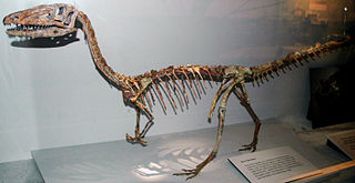
Coelophysis is a genus of coelophysid theropod dinosaur that lived approximately 228 to 201.3 million years ago during the Late Triassic period from the Carnian to Rhaetian ages in what is now the southwestern United States. Megapnosaurus was once considered to be a species within this genus, but this interpretation has been challenged since 2017 and the genus Megapnosaurus is now considered valid.

<span class="mw-page-title-main">Coelophysidae</span> Extinct family of dinosaurs

Coelophysidae is a family of primitive carnivorous theropod dinosaurs. Most species were relatively small in size. The family flourished in the Late Triassic and Early Jurassic periods, and has been found on numerous continents. Many members of Coelophysidae are characterized by long, slender skulls and light skeletons built for speed. One member genus, Coelophysis, displays the earliest known furcula in a dinosaur.

<i>Camposaurus</i> Extinct genus of dinosaurs

Camposaurus is a coelophysid dinosaur genus from the Norian stage of the Late Triassic period of North America. The pertinent fossil remains date back to the early to middle Norian stage, and is widely regarded as the oldest known neotheropod.

<span class="mw-page-title-main">Cutler Formation</span> Geologic formation in the Four Corners, US

The Cutler Formation or Cutler Group is a rock unit that is exposed across the U.S. states of Arizona, northwest New Mexico, southeast Utah and southwest Colorado. It was laid down in the Early Permian during the Wolfcampian epoch.

<span class="mw-page-title-main">Moenkopi Formation</span> Geologic formation in the southwestern United States

The Moenkopi Formation is a geological formation that is spread across the U.S. states of New Mexico, northern Arizona, Nevada, southeastern California, eastern Utah and western Colorado. This unit is considered to be a group in Arizona. Part of the Colorado Plateau and Basin and Range, this red sandstone was laid down in the Lower Triassic and possibly part of the Middle Triassic, around 240 million years ago.

<span class="mw-page-title-main">Chinle Formation</span> Geological formation in the western US

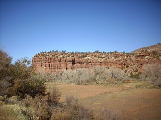
The Chinle Formation is an Upper Triassic continental geological formation of fluvial, lacustrine, and palustrine to eolian deposits spread across the U.S. states of Nevada, Utah, northern Arizona, western New Mexico, and western Colorado. In New Mexico, it is often raised to the status of a geological group, the Chinle Group. Some authors have controversially considered the Chinle to be synonymous to the Dockum Group of eastern Colorado and New Mexico, western Texas, the Oklahoma panhandle, and southwestern Kansas. The Chinle Formation is part of the Colorado Plateau, Basin and Range, and the southern section of the Interior Plains. A probable separate depositional basin within the Chinle is found in northwestern Colorado and northeastern Utah. The southern portion of the Chinle reaches a maximum thickness of a little over 520 meters (1,710 ft). Typically, the Chinle rests unconformably on the Moenkopi Formation.

<span class="mw-page-title-main">Wingate Sandstone</span> Geologic formation across the Colorado Plateau, USA

The Wingate Sandstone is a geologic formation in the Glen Canyon Group of the Colorado Plateau province of the United States which crops out in northern Arizona, northwest Colorado, Nevada, and Utah.

Redondasaurus is an extinct genus or subgenus of phytosaur from the Late Triassic of the southwestern United States. It was named by Hunt & Lucas in 1993, and contains two species, R. gregorii and R. bermani. It is the youngest and most evolutionarily-advanced of the phytosaurs.

<span class="mw-page-title-main">Point Lookout Sandstone</span>

The Point Lookout Sandstone is a Cretaceous bedrock formation occurring in New Mexico and Colorado.

<span class="mw-page-title-main">Mancos Shale</span> Late Cretaceous geologic formation of the Western United States

The Mancos Shale or Mancos Group is a Late Cretaceous geologic formation of the Western United States.

<span class="mw-page-title-main">Shinarump Conglomerate</span>

The Shinarump Conglomerate is a geologic formation found in the Four Corners region of the United States. It was deposited in the early part of the Late Triassic period.

<span class="mw-page-title-main">El Cobre Canyon Formation</span> Geologic formation in New Mexico, United States

The El Cobre Canyon Formation is a geologic formation in New Mexico. It preserves fossils dating back to the late Pennsylvanian to early Permian periods.

<span class="mw-page-title-main">Yeso Group</span> Group of geologic formations in New Mexico, US

The Yeso Group is a group of geologic formations in New Mexico. It contains fossils characteristic of the Kungurian Age of the early Permian Period.

<span class="mw-page-title-main">Petrified Forest Member</span> Lithostratigraphic layer of the Chinle formation

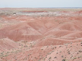
The Petrified Forest Member is a stratigraphic unit of the Chinle Formation in Arizona, Colorado, New Mexico, Nevada, and Utah. It preserves fossils dating back to the Triassic period.

<span class="mw-page-title-main">Salitral Formation</span> Triassic geologic formation in New Mexico, United States

The Salitral Formation is a Late Triassic geologic formation found in north-central New Mexico, primarily the northwestern Jemez Mountains. It is an older subunit of the Chinle Group, overlying the Shinarump Conglomerate and underlying the Poleo Formation.

<span class="mw-page-title-main">Burro Canyon Formation</span> Geologic formation in the southwestern US

The Burro Canyon Formation is an Early Cretaceous Period sedimentary geologic formation, found in western Colorado, the Chama Basin and eastern San Juan Basin of northern New Mexico, and in eastern Utah, US.

<span class="mw-page-title-main">Rock Point Formation</span> Geologic formation in the United States

The Rock Point Formation is a geologic formation in New Mexico, Arizona, and Utah. It preserves fossils dating back to the late Triassic.

<span class="mw-page-title-main">Geology of New Mexico</span> Overview of the geology of the U.S. state of New Mexico

The geology of New Mexico includes bedrock exposures of four physiographic provinces, with ages ranging from almost 1800 million years (Ma) to nearly the present day. Here the Great Plains, southern Rocky Mountains, Colorado Plateau, and Basin and Range Provinces meet, giving the state great geologic diversity.

<span class="mw-page-title-main">Poleo Formation</span> Geologic formation in northern New Mexico, United States

The Poleo Formation is a geologic formation in northern New Mexico. Its stratigraphic position corresponds to the late Triassic epoch.

<span class="mw-page-title-main">Arroyo del Agua Formation</span>

The Arroyo del Agua Formation is a geologic formation in New Mexico. It preserves fossils dating back to the early Permian period.

References

  1. 1 2 3 4 Lucas, Spencer G.; Zeigler, Kate E.; Heckert, Andrew B.; Hunt, Adrian P. (2005). "Review of Upper Triassic stratigraphy and biostratigraphy in the Chama Basin, northern New Mexico" (PDF). New Mexico Geological Society Field Conference Series. 56: 170–181. Retrieved September 21, 2021.
  2. "Water resources data for the United States, Water Year 2009; gage 08290000, Rio Chama near Chamita, NM" (PDF). USGS . Retrieved July 21, 2010.
  3. Owen, Donald E.; Forgas, Angelique M.; Miller, Shawn A.; Stelly, Ryan J.; Owen, Donald E. Jr. (2005). "Surface and subsurface stratigraphy of the Burro Canyon Formation, Dakota Sandstone, and intertongued Mancos Shale of the Chama Basin, New Mexico" (PDF). New Mexico Geological Society Field Conference Series. 56. Retrieved September 21, 2021.
  4. Lucas, Spencer G.; Hunt, Adrian P.; Spielmann, Justin A. (2005). "Jurassic stratigraphy in the Chama Basin, northern New Mexico" (PDF). New Mexico Geological Society Field Conference Series. 56. Retrieved September 21, 2021.
  5. Lucas, Spencer G.; Krainer, Karl (2005). "Stratigraphy and correlation of the Permo-Carboniferous Cutler Group, Chama Basin, New Mexico" (PDF). New Mexico Geological Society Field Conference Series. 56: 145–159. Retrieved September 21, 2021.
  6. Lucas, Spencer G.; Harris, Susan K.; Spielmann, Justin A.; Berman, David S.; Henrici, Amy C.; Heckert, Andrew B.; Zeigler, Kate E.; Rinehart, Larry F. (2005). "Early Permian vertebrate assemblage and its biostratigraphic significance, Arroy del Agua, Rio Arriba County, New Mexico" (PDF). New Mexico Geological Society Field Conference Series. 56. Retrieved July 11, 2020.
  7. Rinehart, L.F.; Lucas, S.G.; Heckert, A.B.; Spielmann, J.A.; Celesky, M.D. (2009). "The paleobiology of Coelophysis bauri (Cope) from the Upper Triassic (Apachean) Whitaker quarry, New Mexico, with detailed analysis of a single quarry block". New Mexico Museum of Natural History & Science, A Division of the Department of Cultural Affairs Bulletin. 45: 260.

36°38′N106°41′W / 36.64°N 106.69°W / 36.64; -106.69