
Anthracite, also known as hard coal and black coal, is a hard, compact variety of coal that has a submetallic lustre. It has the highest carbon content, the fewest impurities, and the highest energy density of all types of coal and is the highest ranking of coals.
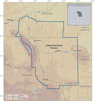
The Powder River Basin is a geologic structural basin in southeast Montana and northeast Wyoming, about 120 miles (190 km) east to west and 200 miles (320 km) north to south, known for its extensive coal reserves. The former hunting grounds of the Oglala Lakota, the area is very sparsely populated and is known for its rolling grasslands and semiarid climate.
Nawab Akbar Shahbaz Khan Bugti was a Pakistani politician and the Tumandar (head) of the Bugti tribe of Baloch people who served as the Minister of State for Interior and Governor of Balochistan Province in Pakistan. He also became minister of state for defence in the cabinet of Feroz Khan Noon. Earlier, he had also served as the Minister of State for Interior.
The history of Balochistan began in 650 BCE with vague allusions to the region in Greek historical records. Balochistan is divided between the Pakistani province of Balochistan, the Iranian province of Sistan and Baluchestan and the Afghan region of Balochistan. Prehistoric Balochistan dates to the Paleolithic.

Barkhan is a district in the Pakistani province of Balochistan. It shares its borders with the province of Punjab to the east and the Balochistan districts of Dera Bugti to the south, Kohlu to the west, Loralai to the northwest and Musakhel to the north. The district's headquarters is the town of Barkhan. It was granted the status of a separate district on 31 December 1991, prior to which it was a tehsil within Loralai District.

Sibi is a district in the Balochistan province of Pakistan. The main mountain ranges are Zen, Bambore and Dungan. The climatic and topography of Sibi District is quite varied compared to other districts of Balochistan. It is also known as the "Hot spot" of Pakistan where the temperatures in the summer exceed 52.6 °C (126.7 °F). Until 2013 the district had two sub-divisions, Sibi and Lehri, further organized into Tehsils and sub-tehsils: Sibi, Lehri, Kutmandi and Sangan. Lehri was rejoined with Sibi district in 2018.

Nawab Khair Bakhsh Marri was a Pakistani politician and head of the Baloch Marri tribe. He joined politics in the 1960s and remained active until his death in 2014.

The Khetrans are an Ethnolinguistic tribe found primarily in Dera Ghazi Khan and Barkhan District of Balochistan. Their area is a large hilly tract in the Sulaiman Mountains comprising the whole of Barkhan and Dera Ghazi Khan District as well as small parts of neighbouring Kohlu District to the south-west, and Musakhel District to the north. The total population is about 150,000, and at least two-thirds are speakers of the Khetrani language. Khetrans who have settled to the east in the Dera Ghazi Khan District of Punjab; they speak the Saraiki language. who are sometimes considered as decendents of chief or ancestors of khetrans. Khetrans are also present in Sindh.
Mawand is located in the Kohlu District of Balochistan, Pakistan. With a population of approximately 5000 people, it is located in district Kohlu and previously it was NCB division It is the place where the first helicopter to start the counter-insurgency operations landed. A fort housing the Frontier Corpsmen and officers also existed there but was destroyed in an earthquake.
Pakistan has coal deposits in Sindh, Punjab and Baluchistan provinces. The total coal resources there are reported to be approximately 185 billion tonnes.

Marri-Bugti Country was a tribal region during the period of British colonial rule in Baluchistan. Marris and Bugtis are the strongest Baloch tribes in the Balochistan. The Marris occupied 8,460 square kilometres (3,268 sq mi) in the north, while the Bugtis occupied 10,000 square kilometres (3,861 sq mi) in the south. Today, the region is divided into three districts: Kohlu, Dera Bugti and Sibi.
Sher Mohammad Marri was the chief of the Marri Baloch tribe in Pakistan, and an early leader in the Parrari movement which would lead to the formation of the Baloch Liberation Army, a militant nationalist group. A Marxist, he had close ties to leftist governments in Kabul and Moscow.
According to the United States Energy Information Administration (EIA), Pakistan may have over 9 billion barrels (1.4×10⁹ cubic metres) of petroleum oil and 105 trillion cubic feet (3.0 trillion cubic metres) in natural gas (including shale gas) reserves.
Pakistan's industrial sector accounts for 28.11% of the GDP. Of this, manufacturing makes up 12.52%, mining constitutes 2.18%, construction makes up 2.05%, and electricity and gas 1.36%. The majority of industry is made up of textile units, with textiles contributing $15.4b to exports, making up 56% of total exports. Other units include surgical instruments, chemicals, and a budding automotive industry.
The Anglo-Marri Wars is the name given to three major military conflicts between the Marri Baloch tribesmen and the British Empire in the independent eastern Baloch tribal belt. The conflicts took place in the 19th and 20th centuries, specifically in 1840, 1880, and 1917.

The economy of Balochistan, one of the four provinces of Pakistan, is largely based upon the production of natural gas, coal, and minerals. Agriculture and livestock also dominate the Baloch economy. Horticultural development is a fairly recent, yet growing phenomenon. Other important economic sectors include fisheries, mining, manufacturing industries, trade and other services being rendered by public and private sector organizations in the province.

The Afghanistan–Pakistan border barrier refers to the border barrier being built by Pakistan since March 2017 along its border with Afghanistan. The purpose of barrier is to prevent terrorism, arms, and drug trafficking, as well refugees, illegal immigration, smuggling and infiltration across the approximately 2,670-kilometre-long (1,660 mi) international border between Afghanistan and Pakistan.
Mohabat Khan Marri is a Pakistani Politician and a former Member of Senate of Pakistan.

Operations against the Marri and Khetran tribes was the British name for a punitive expedition carried out against the Marri and Khetran tribes of Balochistan, British India between February and April 1918. The Marri rose against the British authorities around 18 February, encouraged by rumours that the British were short of manpower due to the First World War. British attempts at conciliation were repulsed and, on 20 February, a major attack was made by 1,000 – 3,000 Marri upon the British post at Gumbaz. This attack was repulsed by a much smaller British force that inflicted heavy losses upon the Marri. A subsequent withdrawal of British forces from Kohlu and its occupation by the Marri led the Khetrans to join the rising. The town of Barkhan was occupied by Marri-Khetran forces and raids were made upon villages in the Sibi and Loralai districts; railways in the area were also attacked.

