Kohlu District

Last updated

Kohlu District
ضلع کوہلو
کۏهلو دمگ
Pakistan - Balochistan - Kohlu.svg
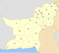
Map of Balochistan Districts with Kohlu District highlighted
CountryFlag of Pakistan.svg  Pakistan
Province Flag of Balochistan.svg  Balochistan
Division Sibi
Established1974
Headquarters Kohlu
Government
  TypeDistrict Administration
   Deputy Commissioner N/A
  District ChairmanMir Nisar Ahmed Marri (PTI)
  District Vice ChairmanGhazi Khan Loharani (PTI)
Area
[1]
  Total
7,610 km2 (2,940 sq mi)
Population
  Total
260,220
  Density34/km2 (89/sq mi)
Time zone UTC+5 (PST)
Number of Tehsils 3

Kohlu district (Balochi : کوہلو, Urdu : ضلع کوہلو) is a district of the Balochistan province of Pakistan. [3] It is bounded in the north by Loralai District, with Dera Bugti in the south, Barkhan in the east, and Sibi District in the west.

Contents

Administration

TehsilArea

(km²) [4]

Pop.

(2023)

Density

(ppl/km²)

(2023)

Literacy rate

(2023) [5]

Union Councils
Kahan Tehsil 3,754107,84028.7319.87%...
Kohlu Tehsil 23148,050208.0149.76%...
Maiwand Tehsil 2,91551,63517.7125.75%...
Tamboo Tehsil 53637,44969.8729.32%...
Shaheed Jahangir Abad ...............
Grisani Tehsil 17415,24687.6234.40%...

Demographics

Historical population
YearPop.±% p.a.
1951N/A    
1961N/A    
1972N/A    
1981N/A    
199899,846    
2017213,933+4.09%
2023260,220+3.32%
Sources: [6]

Population

As of the 2023 census, Kohlu district has 38,095 households and a population of 260,220. The district has a sex ratio of 109.91 males to 100 females and a literacy rate of 28.53%: 32.65% for males and 23.93% for females. [7] [8] 96,678 (37.15% of the surveyed population) are under 10 years of age. [9] 18,978 (7.29%) live in urban areas. [7]

Religion

Religions in present-day Kohlu district
Religion2017 [10] 2023 [11]
Pop.%Pop.%
Islam Star and Crescent.svg 213,64499.86%259,21399.61%
Christianity Christian cross.svg 2230.10%9210.35%
Others660.03%860.04%
Total Population213,933100%260,220100%

Language

Languages of Kohlu district (2023)

   Balochi (95.61%)
   Pashto (3.97%)
  Others (0.42%)

At the time of the 2023 census, 95.61% of the population spoke Balochi and 3.97% Pashto as their first language. [12]

Education

According to the Pakistan District Education Rankings 2017, district Kohlu is ranked at number 116 out of the 141 ranked districts in Pakistan on the education score index. This index considers learning, gender parity and retention in the district.

Literacy rate in 2014–15 of population 10 years and older in the district stands at 32%, whereas for females it is only 12%. [13]

Post primary access is a major issue in the district with 91% of schools being at primary level. Compare this with high schools, which constitute only 4% of government schools in the district. This is also reflected in the enrollment figures for 2015–17 with 2,754 students enrolled in class 1 to 5 and only 8 students enrolled in class 9 and 10.

Gender disparity is another issue in the district. Only 20% schools in the district are girls’ schools. Access to education for girls is a major issue in the district and is also reflected in the low literacy rates for females.

Moreover, the schools in the district lack basic facilities. According to Alif Ailaan district education rankings 2017, the district is ranked at number 150 out of the 155 districts of Pakistan for primary school infrastructure. At the middle school level, it is ranked at number 149 out of the 155 districts. These rankings take into account the basic facilities available in schools including drinking water, working toilet, availability of electricity, existence of a boundary wall and general building condition. More than 4 out of 5 schools do not have electricity. 9 out 10 schools lack a toilet and 3 out of 4 schools do not have a boundary wall. 1 out of 2 schools do not have clean drinking water.

Related Research Articles

<span class="mw-page-title-main">Chagai District</span> District of Balochistan in Pakistan

Chaghi District, also known as Chaghi District, is the largest district of Pakistan by area, located in the northwestern corner of the Balochistan province of Pakistan. District shares the border with two countries: Afghanistan and Iran.

<span class="mw-page-title-main">Zhob District</span> District of Balochistan in Pakistan

Zhob District is a district in the northwestern part of Balochistan province of Pakistan. The population of Zhob District was estimated at 355,692 in 2023. Water from Zhob River is used for irrigation in the district.

<span class="mw-page-title-main">Loralai District</span> District of Balochistan in Pakistan

Loralai District is a district in the northeast of Balochistan province of Pakistan. The town of Loralai serves as the district headquarters.

<span class="mw-page-title-main">Kachhi District</span> District of Balochistan in Pakistan

Kachhi or Kacchi, previously known until 2008 as Bolan District, is a district located in the central part of the Balochistan province in Pakistan. The Bolan area remained under one district Kacchi until 31 December 1991. The Deputy Commissioner's office started functioning on 17 May 1992, and Bolan became one of the four districts of Naseerabad Division, until the abolition of Divisions in 2000.

<span class="mw-page-title-main">Jafarabad District</span> District of Balochistan in Pakistan

Jafarabad, district lies in the southeastern part of Pakistan's province of Balochistan. Dera Allah Yar, also known as Jhatpat among locals, serves as the district headquarters. Jaffarabad District is sub-divided into two tehsils. According to 2023 Pakistani census Jafarabad district has a population of 594,558.

<span class="mw-page-title-main">Khuzdar District</span> District of Balochistan in Pakistan

Khuzdar is a district in the Balochistan province of Pakistan. The city of Khuzdar serves as the district's headquarters.

<span class="mw-page-title-main">Mastung District</span> District of Balochistan in Pakistan

Mastung District is a district located in the northwest of Balochistan province, Pakistan. Prior to its creation as a separate district in 1991, Mastung was part of Kalat District.

<span class="mw-page-title-main">Kharan District</span> District of Balochistan in Pakistan

Kharan district is a district in the Balochistan province of Pakistan.

<span class="mw-page-title-main">Kalat District</span> District in Balochistan, Pakistan

Kalat District is a district located in Kalat Division of Balochistan, Pakistan. Kalat was made a separate district on February 3, 1954. At that time Khuzdar and Mastung districts were sub-divisions of Kalat. Khuzdar became a separate district by notification of 1 March 1974, while Mastung was announced as a separate district on 18 February 1992. The district draws its name from the ancient city of Kalat. The old name of the district headquarters was Kahan. The current district consists of two sub-divisions, i.e. Kalat and Manguchar, four tehsils: Kalat Mangochar, Johan, and Gazgz, 81 Patwar circles and 614 mauza (villages).

<span class="mw-page-title-main">Nushki District</span> District of Balochistan in Pakistan

Nushki District is one of the districts of Balochistan province, Pakistan. The administration of the Nushki district was taken over from the Khan of Kalat by the British government in 1896 and was leased from him on a perpetual quit rent in 1899.

<span class="mw-page-title-main">Killa Abdullah District</span> District of Balochistan in Pakistan

Kila Abdullah District or Qilla Abdullah is a district in the northwestern part of Balochistan province of Pakistan.

<span class="mw-page-title-main">Sibi Division</span> Administrative Division of Balochistan, Pakistan

Sibi Division is a division of Balochistan province of Pakistan. It contains the following districts: This department was established in 1974 in this state. CNIC Code of Sibi Division is 55.

<span class="mw-page-title-main">Hub District</span> District in Balochistan, Pakistan

Hub District, is a coastal administrative district and located at southern part of Balochistan Province of Pakistan. The district was created after bifurcation of Lasbela District in 2022.

<span class="mw-page-title-main">Harnai District</span> District in Balochistan, Pakistan

Harnai is a district in the northeastern part of the Balochistan province of Pakistan. Harnai is the principal town of this district and serves as its administrative headquarters.

<span class="mw-page-title-main">Duki District</span> District of Balochistan in Pakistan

Duki is a district in the Balochistan province of Pakistan.

<span class="mw-page-title-main">Ziarat District</span> District in Balochistan, Pakistan

Ziarat is a district in the north of Balochistan province of Pakistan. Ziarat town is the headquarters of the district, the sub-division, and also of the tehsil. The highest peak of Khalifat Hills, at an altitude of 11,400 feet (3,500 m), is located in Ziarat district.

<span class="mw-page-title-main">Killa Saifullah District</span> District of Balochistan in Pakistan

Kila Saifullah District, Qilla Saifullah, or Saifullah Killa is a district in northwestern Balochistan province, Pakistan. It was established as a district in 1988, comprising two former administrative units of Zhob District: the Upper Zhob sub division and the sub tehsil of Badinai, previously named Kashatoo and part of the sub-district of Kakar Khurasan.

<span class="mw-page-title-main">Washuk District</span> District of Balochistan in Pakistan

Washuk District is a district in Balochistan province of Pakistan. The town of Washuk, which serves as the district headquarters, is located in the center of the district.

<span class="mw-page-title-main">Sohbatpur District</span> District of Balochistan in Pakistan

Sohbatpur District is a district in the Pakistani province of Balochistan.

<span class="mw-page-title-main">Chaman District</span> District in Balochistan, Pakistan

Chaman District is a district of Balochistan Province, Pakistan. Chaman District was created after the bifurcation of Qila Abdullah District in 2021.

References

  1. PCO 1999, p. 13.
  2. "Population by Sex, Religion and Rural/Urban, Census - 2023" (PDF). Pakistan Bureau of Statistics.
  3. "New Gas Reserves Found In Pakistan (in Kohlu District)". ARY TV News website. Archived from the original on 21 October 2021. Retrieved 2 March 2024.
  4. "TABLE 1 : AREA, POPULATION BY SEX, SEX RATIO, POPULATION DENSITY, URBAN POPULATION, HOUSEHOLD SIZE AND ANNUAL GROWTH RATE, CENSUS-2023, BALOCHISTAN" (PDF).
  5. "LITERACY RATE, ENROLMENT AND OUT OF SCHOOL POPULATION BY SEX AND RURAL/URBAN, CENSUS-2023, BALOCHISTAN" (PDF).
  6. "Population by administrative units 1951-1998" (PDF). Pakistan Bureau of Statistics.
  7. 1 2 "7th Population and Housing Census - Detailed Results: Table 1" (PDF). Pakistan Bureau of Statistics .
  8. "7th Population and Housing Census - Detailed Results: Table 12" (PDF). Pakistan Bureau of Statistics .
  9. "7th Population and Housing Census: Population by Mother Tongue, Sex and Rural/Urban" (PDF). Pakistan Bureau of Statistics .
  10. "Pakistan Census 2017 District-Wise Tables: Kohlu". Pakistan Bureau of Statistics .
  11. "7th Population and Housing Census - Detailed Results: Table 9" (PDF). Pakistan Bureau of Statistics .
  12. "Population by Mother Tongue, Sex and Rural/Urban, Census-2023" (PDF). Pakistan Bureau of Statistics.
  13. Pakistan Bureau of Statistics (2016). Pakistan Social and Living Standards Measurement Survey 2014-15 . Government of Pakistan website, p.111. Retrieved 2 March 2024

Bibliography

29°53′59″N69°15′03″E / 29.8997°N 69.2507°E / 29.8997; 69.2507