
Gadchiroli district is an administrative district in Maharashtra, India. The city of Gadchiroli is the administrative headquarters of the district.
Baripada is a city and a municipality in Mayurbhanj district in the state of Odisha, India. Located along the east bank of the Budhabalanga river, Baripada is the cultural centre of north Odisha. In recent years, it has emerged as an educational hub with the opening of numerous professional colleges.

Nahan is a town in Himachal Pradesh in India and is the headquarters of the Sirmaur District It was the capital of the former Sirmur princely state.Nahan is also known as the Town of ponds.

The Wainganga is a river in India originating in the Mahadeo Hills in Mundara near the village Gopalganj in Seoni, Madhya Pradesh. It is a key tributary of the Godavari. The river flows south in a winding course through the states of Madhya Pradesh and Maharashtra, roughly 580 km (360 mi). After joining the Wardha River, the united stream, which is known as the Pranahita River, empties into the Godavari River at Kaleshwaram, Telangana.
Seoni is a city and a municipality in Seoni district in the Indian state of Madhya Pradesh. This tribal household dominated district was formed in the year 1956. Rudyard Kipling used the forests in the vicinity of Seoni, or as was spelled during British colonial rule, Seeonee, as the setting for the Mowgli stories in The Jungle Book and The Second Jungle Book (1894–1895), although the area is not an actual rainforest. Seoni is a city where tributary of the river Godavari, the Wainganga, originates. Seoni is reachable by road, major adjacent cities are Nagpur and Jabalpur. The National Highway 44 north–south corridor crosses from Seoni. The nearest airport is Nagpur (130 km); a small airport (air-strip) is available at Seoni near Sukhtara village for landing charter airplanes/helicopters. The Wainganga is a river in India originating in the Mahadeo Hills in Mundara near the village Gopalganj in Seoni, Madhya Pradesh. It is a key tributary of the Godavari. The river flows south in a winding course through the states of Madhya Pradesh and Maharashtra, roughly 579 km (360 mi). After joining the Wardha River, the united stream, which is known as the Pranahita River, empties into the Godavari River at Kaleshwaram, Telangana.

Rajnandgaon is a district of the state of Chhattisgarh in central India. The administrative headquarters the district is Rajnandgaon town.
Gadchiroli is a city and a municipal council in Gadchiroli district in the state of Maharashtra, central India. It is located on eastern side of Maharashtra, and is the administrative headquarters of the district. Gadchiroli is called a lung of Maharashtra as it has almost 35% of this district has forest cover. The main river flowing through city is the Wainganga River. The landscape is lush and green during the monsoon season which is prone to flooding. Gadchiroli is known for its forests. Teak is grown commercially and bamboos are used for various crafts.

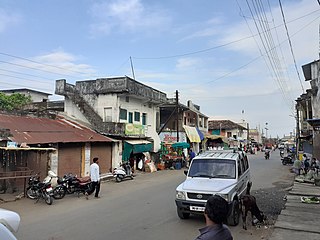
Desaiganj also known as Navi Wadsa is a Large Village and a municipal council in the Wadsa taluka in Gadchiroli district in the state of Maharashtra, India. The village of Wadsa, now called Juni Wadsa lies 2 km to the south-west. The town is situated on the banks of river Wainganga.
Khanapur officially known as Khanapura is a panchayat town in Belagavi district, Karnataka, India. It is about 26 km from Belagavi. The town is governed by the Khanapur Municipal Council. Khanapur is the headquarters for Khanapur taluk. The town is on the Belgaum-Panaji National Highway, NH 4A. Khanapur is well connected by train and road to important cities in Karnataka, Goa, and Maharashtra. Kannada is the official language but Marathi is widely spoken in the town.
Mul is a town and a municipal council in Chandrapur district in the Indian state of Maharashtra. Pincode of Mul is 441224.
Shahabad Markanda is a sub division of Kurukshetra district within the Indian state of Haryana. It is situated on the left bank of the Markanda River, 20 km (12 mi) south of Ambala Cantonment and 22 km (14 mi) from the historical city of Kurukshetra.
Aheri is a town and a tehsil and a district sub-division in Gadchiroli district in the Indian state of Maharashtra. It is located on the bank of Pranhita River, a tributary of Godavari River. This town is situated at the border of the Indian states of Maharashtra and Telangana. Aheri is known for its unity among the people. It represents religious, cultural and linguistic diversity. Aheri is among two Scheduled Area listed under Gadhiroli district by Government Of India. Viththal Rukhmai Mandir is the famous temple here, located right at the heart of the town.

Armori is a town and municipal council in the Gadchiroli district in the Indian state of Maharashtra. It is connected with the National Highway NH-353C.

Andhra Pradesh is a state in India. Andhra Pradesh Tourism Development Corporation (APTDC) is a state government agency which promotes tourism in Andhra Pradesh, describing the state as the Koh-i-Noor of India. Andhra Pradesh has a variety of tourist attractions including beaches, hills, caves, wildlife, forests and temples.
The Markandeshwar Mahadev temple is a Shiva temple, located in the town of Shahabad Markanda, which is situated in the Kurukshetra district of Haryana in North India. The name Markandeshwar is associated with Maharishi Markandeya, a great devotee of Shiva.

The Pranhita River is the largest tributary of Godavari River covering about 34% of its drainage basin conveying the combined waters of the Penganga River, the Wardha River, and the Wainganga River. By virtue of its extensive network of tributaries, the river drains a large part of Vidarbha region in Maharashtra, as well as the southern slopes of the Satpura Range in southeast Madhya Pradesh. It flows along the border of Gadchiroli district in Maharashtra and Komaram Bheem Asifabad district in Telangana. The Pranahita sub-basin is the seventh largest in India, measuring about 109,078 km2, making it larger than the individual basins of significant rivers such as the Narmada River and Kaveri.
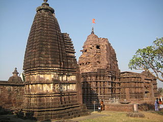
Markanda Mahadev Temple Complex is situated at the banks of the Wainganga River near Chamorshi town in the Gadchiroli District of Maharashtra. This 8th Century Temple Complex is called Mini Khajuraho. The nearest village is Marakand Deo.
Markanda is a former name for the city of Samarkand in Uzbekistan.

Por river is a minor river in Gadchiroli district of Maharashtra. It is a minor tributary of Wainganga river and falls into it near Chamorshi.
Juni Wadsa also known as Wadsa gaon is a village in the Wadsa taluka in Gadchiroli district in the state of Maharashtra, India. The town of "New Wadsa", now called Desaiganj lies 2 km to the north-east. The village is situated on the banks of river Wainganga.

