Champ de Mars, Montreal

Last updated
Montreal's fortifications
in Champ de Mars, Montreal Quebec, Canada
TypeMontreal's fortifications, formerly a parade grounds and city walls
Champ de Mars, location of original walls. Champ de mars Montreal.JPG
Champ de Mars, location of original walls.
David Ross' house overlooking the Champ de Mars, built circa 1800 David Ross House, Champ de Mars, Montreal.jpg
David Ross' house overlooking the Champ de Mars, built circa 1800

Champ de Mars is a public park in Old Montreal quarter of Montreal, Quebec, Canada.

Urban park park in a city or other incorporated place

An urban park or metropolitan park, also known as a municipal park or a public park, public open space, or municipal gardens (UK), is a park in cities and other incorporated places to offer recreation and green space to residents of, and visitors to, the municipality. The design, operation and maintenance is usually done by government agencies, typically on the local level, but may occasionally be contracted out to a park conservancy, friends of group, or private sector company.

Old Montreal Neighbourhood of Montreal in Quebec, Canada

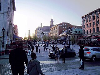
Old Montreal is a historic neighbourhood within the municipality of Montreal in the province of Quebec, Canada. Founded by French settlers in 1642 as Fort Ville-Marie, Old Montreal is home to many structures dating back to the era of New France. The 17th century settlement lends its name to the borough in which the neighbourhood lies, Ville-Marie. Home to the Old Port of Montreal, the neighbourhood is bordered on the west by McGill Street, on the north by Ruelle des Fortifications, on the east by rue Saint-André, and on the south by the Saint Lawrence River. Following recent amendments, the neighbourhood has expanded to include the Rue des Soeurs Grises in the west, Saint Antoine Street in the north, and Saint Hubert Street in the east. In 1964, much of Old Montreal was declared a historic district by the Ministère des Affaires culturelles du Québec.

Montreal City in Quebec, Canada

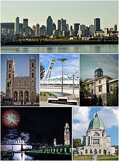
Montreal is the most populous municipality in the Canadian province of Quebec and the second-most populous municipality in Canada. Originally called Ville-Marie, or "City of Mary", it is named after Mount Royal, the triple-peaked hill in the heart of the city. The city is centred on the Island of Montreal, which took its name from the same source as the city, and a few much smaller peripheral islands, the largest of which is Île Bizard. It has a distinct four-season continental climate with warm to hot summers and cold, snowy winters.

Contents

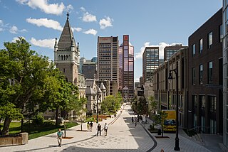
Formerly a military parade ground, the park had previously been the site of Montreal's fortifications, which were demolished at the beginning of the 19th century soon after Montreal City Hall and the old courthouse were built. It had served as a municipal parking lot until being restored as a park in 1980s. At that time, the foundations of Montreal's city walls were discovered and restored.

The Citadel, Montreal demolished fortress in Montreal, Quebec

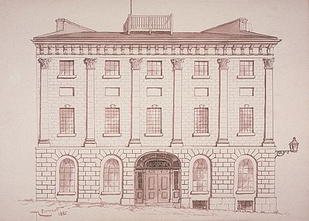
The Citadel of Montreal was a former fortress used to defend the city.

Montreal City Hall city hall of Montreal

The five-story Montreal City Hall is the seat of local government in Montreal, Quebec, Canada. It was designed by architects Henri-Maurice Perrault and Alexander Cowper Hutchison, and built between 1872 and 1878 in the Second Empire style. It is located in Old Montreal, between Place Jacques-Cartier and the Champ de Mars, at 275 Notre-Dame Street East. The closest Metro station is Champ-de-Mars, on the Orange Line.

Parking lot Cleared area that is intended for parking vehicles

A parking lot or car park, also known as a car lot, is a cleared area that is intended for parking vehicles. Usually, the term refers to a dedicated area that has been provided with a durable or semi-durable surface. In most countries where cars are the dominant mode of transportation, parking lots are a feature of every city and suburban area. Shopping malls, sports stadiums, megachurches and similar venues often feature parking lots of immense area. See also multistorey car park.

The site's name commemorates its former military purpose; Mars was the Roman god of war and campus Martius was a Latin term for a military exercise ground. [1] The walls now standing on site were built to show the location of the original walls used to protect the city. [2]

Mars (mythology) Roman god of war, and guardian of agriculture

In ancient Roman religion and myth, Mars was the god of war and also an agricultural guardian, a combination characteristic of early Rome. He was second in importance only to Jupiter and he was the most prominent of the military gods in the religion of the Roman army. Most of his festivals were held in March, the month named for him, and in October, which began the season for military campaigning and ended the season for farming.

Latin Indo-European language of the Italic family

Latin is a classical language belonging to the Italic branch of the Indo-European languages. The Latin alphabet is derived from the Etruscan and Greek alphabets and ultimately from the Phoenician alphabet.

The area is bordered by the Montreal City Hall, the old and new courthouses and the Champ-de-Mars Metro station.

See also

Related Research Articles

Marcelle Ferron Canadian artist

Marcelle Ferron,, a Canadian Québécoise painter and stained glass artist, was a major figure in the Quebec contemporary art scene, associated with the Automatistes.

Champ de Mars large public green space in Paris, France

The Champ de Mars is a large public greenspace in Paris, France, located in the seventh arrondissement, between the Eiffel Tower to the northwest and the École Militaire to the southeast. The park is named after the Campus Martius in Rome, a tribute to the Latin name of the Roman God of war. The name also alludes to the fact that the lawns here were formerly used as drilling and marching grounds by the French military.

Architecture of Montreal

The architecture of Montreal, Quebec, Canada is characterized by the juxtaposition of the old and the new and a wide variety of architectural styles, the legacy of two successive colonizations by the French, the British, and the close presence of modern architecture to the south. Much like Quebec City, the city of Montreal had fortifications, but they were destroyed between 1804 and 1817.

Underground City, Montreal network of connected buildings in Montreal

RÉSO, commonly referred to as The Underground City, is the name applied to a series of interconnected office towers, hotels, shopping centres, residential and commercial complexes, convention halls, universities and performing arts venues that form the heart of Montreal's central business district, colloquially referred to as Downtown Montreal. The name refers to the underground connections between the buildings that compose the network, in addition to the network's complete integration with the city's entirely underground rapid transit system, the Montreal Metro. Moreover, the first iteration of the Underground City was developed out of the open pit at the southern entrance to the Mount Royal Tunnel, where Place Ville Marie and Central Station stand today.

Place Jacques-Cartier square in Montreal, Canada

Place Jacques-Cartier is a square located in Old Montreal, Quebec, Canada. It is an entrance to the Old Port of Montreal.

Champ-de-Mars station (Montreal Metro) Montreal Metro station

Champ-de-Mars station is a Montreal Metro station in the borough of Ville-Marie in Montreal, Quebec, Canada. It is operated by the Société de transport de Montréal (STM) and serves the Orange Line. It is located in Old Montreal by the Champ de Mars park. It opened on October 14, 1966, as part of the original Metro network.

Ottawa City Hall City Hall in Ottawa (Ontario)

The current Ottawa City Hall is the city hall of Ottawa, Ontario, Canada. The downtown complex consists of two connected buildings: a modern wing located on Laurier Avenue and a 19th-century heritage wing located on Elgin Street. Although City Hall has frontage on two major streets, the main entrance is on Laurier Avenue, and the municipal address is 110 Laurier Avenue West.

Ville-Marie, Montreal Borough of Montreal in Quebec, Canada

Ville-Marie is the name of a borough (arrondissement) in the centre of Montreal, Quebec. The borough is named after Fort Ville-Marie, the French settlement that would later become Montreal, which was located within the present-day borough. Old Montreal is a National Historic Site of Canada.

Villeray–Saint-Michel–Parc-Extension Borough of Montreal in Quebec, Canada

Villeray–Saint-Michel–Parc-Extension is a borough (arrondissement) in the city of Montreal, Quebec. It had a population of 142,222 according to the 2011 Census and a land area of 16.5 square kilometres (6.4 sq mi).

Palais de justice (Montreal) building in Quebec, Canada

The Palais de justice is a courthouse in Montreal, Quebec, Canada. It is located at 1 Notre-Dame Street East in the Old Montreal neighbourhood of the Ville-Marie borough. It was completed in 1971.

Notre-Dame-de-Bon-Secours Chapel Church in Montreal, Quebec

The Notre-Dame-de-Bon-Secours Chapel is a church in the district of Old Montreal in Montreal, Quebec. One of the oldest churches in Montreal, it was built in 1771 over the ruins of an earlier chapel. The church is located at 400 Saint Paul Street East at Bonsecours Street, just north of the Bonsecours Market in the borough of Ville-Marie.

Montreal Metro Rubber-tired metro system in Montreal, Quebec

The Montreal Metro is a rubber-tired, underground rapid transit system serving the city of Montreal, Quebec, Canada.

Park Avenue (Montreal) one of central Montreals major north-south streets

Park Avenue is one of central Montreal's major north-south streets. It derives its name from Mount Royal Park, by which it runs. Between Mount Royal Avenue and Pine Avenue, the street separates the eastern side of the mountain park and the smaller Jeanne Mance Park.

Champ de Mars is a large public greenspace in Paris, France.

Notre-Dame Street street in Montreal, Quebec

Notre-Dame Street is a historic east-west street located in Montreal, Quebec, Canada. It runs parallel to the Saint Lawrence River, from the eastern tip of the island to Lachine.

Laurier Avenue (Montreal) street in Montreal, Canada

Laurier Avenue is a commercial and residential street in Montreal, Quebec, Canada. It crosses the boroughs of Outremont, Le Plateau-Mont-Royal and Rosemont–La Petite-Patrie. It is known for its cafés, restaurants and specialty stores, especially near Park Avenue and east of Sir Wilfrid Laurier Park.

Jeanne Mance Street is a north-south street in Montreal, Quebec, Canada, located east of Park Avenue. It was named in 1914 in honour of Jeanne Mance, the founder of the Hôtel-Dieu de Montréal, which is also located along this street.

References

  1. "Origin of the name Champ-de-Mars". Tour toponymique Les stations de métro, Communauté urbaine de Montréal, 1989. STM Web site. Archived from the original on 2013-05-27. Retrieved 2008-03-05.
  2. "Champ de Mars". Montreal Travel Guide.com. Archived from the original on 2008-04-15. Retrieved 2008-03-05.

Coordinates: 45°30′32″N73°33′19″W / 45.50889°N 73.55528°W / 45.50889; -73.55528

Geographic coordinate system Coordinate system

A geographic coordinate system is a coordinate system that enables every location on Earth to be specified by a set of numbers, letters or symbols. The coordinates are often chosen such that one of the numbers represents a vertical position and two or three of the numbers represent a horizontal position; alternatively, a geographic position may be expressed in a combined three-dimensional Cartesian vector. A common choice of coordinates is latitude, longitude and elevation. To specify a location on a plane requires a map projection.