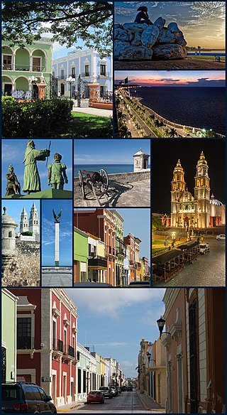
Champotón, Campeche

Last updated • 9 min readFrom Wikipedia, The Free Encyclopedia
Champotón
City
CHAMPOTON - panoramio.jpg
Champotón at Bay of Campeche
Mexico States blank map.svg
Red pog.svg
Champotón
Coordinates: 19°21′N90°43′W / 19.350°N 90.717°W / 19.350; -90.717
Country Flag of Mexico.svg Mexico
State Flag of Campeche.svg Campeche
MunicipalityChampotón
City Founded1538
Government
  MayorXicoténcatl González Hernández (PRI)
Elevation
10 m (30 ft)
Population
 (2010)
  Total30,881
   Demonym
Champotonero
Time zone UTC−6 (CST)
  Summer (DST) UTC−5 (CDT)
Area code 982
Website http://www.champoton.gob.mx/

Champotón is a small city in Champotón Municipality in the Mexican state of Campeche, located at 19°21′N90°43′W / 19.35°N 90.72°W / 19.35; -90.72 , about 60 km south of the city of Campeche where the small Champotón river meets the coast of the Gulf of Mexico. At the 2010 census it had a population of 30,881.

Contents

Champotón, historically also called Chakanputun, Chanpaton [1] and Chanputun, was a city of the Maya civilization dating back to at least the 10th century before it was conquered by Spain in the 16th century. There the famous battle "Mala Pelea" occurred. In the first Spanish exploration (1517), they were defeated by the Maya. Juan de Grijalva's expedition exacted revenge in 1518. [2] :22–24,29

History

According to the Chilam Balam of Chumayel, the Itzáes began to arrive at the Yucatán peninsula in the year 435, begun in Bacalar and rising to the north and west, in this way they also inhabited Chakán Putum.

In the year 869, coming from Nonohual came Ah Mekat Tutul Xiu, who was the chief of the tutul xiúes and forced the first Itzáes to retreat into the jungle and leave Chakán Putum and other cities, the tutul xiúes were settled mainly in Uxmal more late in 987, some of the Itzaes who lived "under the trees, under the ashes and under the misery" returned again to Chichen Itza, others of the Itzaes separated and founded Mayapán (1047 AD), the latter since then He knew them as the "Cocomes".

Cocomes, itzáes and tutul xiúes formed the Mayapán League that began in 1047. The Cocomes made war with the Itzáes who emigrated to the Guatemalan Petén, and later the Tutul Xiúes fought with the Cocomes, eventually disintegrating the union in 1441.

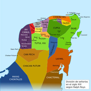
After the Yucatán Peninsula, was divided into 16 cacicazgos, in the state of Campeche, was part of the chiefdom of Ah Canul, Can Pech, and Chakán Putum. The struggles between cacicazgos were frequent, especially between cocomes and tutul xiúes.

In 1517 the first Spanish expedition to the Mexican coasts was made by Francisco Hernández de Córdoba, first Spanish conquistador to arrive to the Yucatán Peninsula, who after having touched Isla Mujeres and Cabo Catoche continued skirting the peninsula's coastline, arriving in Campeche on Sunday of San Lázaro. The natives of Campeche welcomed the Spaniards, in this place they were supplied with water, and they returned to embark to continue their journey, however they incurred the mistake of not closing their pipes and water containers, so they had to disembark again a little further south in a nearby place called Champoton (Chakán Putum).

According to the story of the soldier and chronicler Bernal Díaz del Castillo, it is known that three days later the expeditionaries continued along the coast and reached Chakanputún, which they renamed Champoton and where they met with a thousand heavily armed Maya who attacked the Spaniards by killing to more than 50 and leaving the captain wounded. The Spanish expedition withdrew.

After this fierce fight, the Spaniards had to flee without water and with many wounded, 57 dead and two kidnappings (Alonso Boto and an old Portuguese), the same Hernández de Córdoba left with 33 wounds, because the Mayans soon realized that he was the boss and as described by Diaz del Castillo shouted "calachuni", "calachuni" (which means "the boss"), they fled to Florida, a place known by the pilot Antón de Alaminos looking for water, but there they were also repelled by the natives (Bernal Díaz del Castillo who participated in the trip, was wounded in Florida) and finally returned to the port of Carenas near Havana in Cuba, Hernández de Córdoba would die 10 days later as a result of injuries in Sancti Espiritus.

Due to these events, Champoton was baptized as "Puerto de Mala Pelea". November December The Moch (the "stubby", the one - armed Cohuó) chief was the first Indian hero; This Mayan chief was able to provide the first defeat to a foreign invading army in America.

The following year, in 1518, the second expedition commanded by Juan de Grijalva departed from Cuba, after passing through Cozumel and the Bay of Ascension, they circled the coast of the peninsula again until they reached Champoton again to obtain water, to the experience of the first expedition, the Spaniards were more prepared to face and subdue the natives. The balance of the confrontation inclined to the Europeans who had 7 casualties (among them Juan de Quiteria) and 60 wounded (Juan de Grijalva was wounded with three arrows and lost two teeth), the Mayans couohes suffered many losses (200), among the chief cacique died, and the rest fled inland.

Grijalva sent his translators (Julianillo and Melchorejo, Mayas trapped in Cabo Catoche during the first expedition who had already learned Castilian) to call other caciques, nobody came to the call, so this expedition left Champoton and continued its route to the mouth of the river since then called "Grijalva" in Tabasco, in this expedition came Francisco de Montejo for the first time.

In the third expedition (1519) commanded by Hernán Cortés, his intention was to disembark again to avenge the previous expeditionaries, but the strong wind did not favor the disembarkation, and the pilots convinced Cortés to continue straight ahead with the boats, in such a way that They passed by the Lagoon of Terms, where they would face the Chontal Maya of the region, it is likely that the Mayans of Can Pech, and Chakan Putúm made a common front before the disembarkation made at a point near Zintla (Centla).

After a strong confrontation ( Battle of Centla ), Cortes subdued and agreed with the Mayans founding the town of Santa Maria de la Victoria, (Frontier). It was here that the Mayans gave Cortés to Malintzin along with other slaves as an act of peace, it is possible that "Doña Marina" was a slave of the Mayans of Champotón.

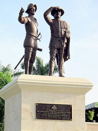
In 1526 Francisco de Montejo, who had participated in the conquest of Tenochtitlan, traveled to Spain and requested permission to carry out the conquest of the Yucatán Peninsula, so in 1526 the Spanish crown awarded Montejo the title of "Adelantado, Governor , Chief Constable and Captain General of Yucatan ". The conquests of Champoton and Campeche were part of the Conquest of Yucatán, which was carried out in three stages.

In the first stage or attempt, Montejo dabbled between 1527 and 1529 in the northeast of the peninsula with the help of Captain Alonso Dávila, but they were repelled by the Mayans. In the second stage or attempt (1530-1535) Montejo dabbled in the west, managing to found in 1531 "Salamanca de Campeche". Alonso Dávila was sent by Montejo to cross the peninsula south and founded in Bacalar Villa Real, but this position had to be abandoned. The mighty Mayans would rebel in the battle of San Bernabé on June 11, 1531, in the vicinity of Campeche.

The son of Montejo known as Montejo "el Mozo" is defeated in the royal city of Chichen Itza towards the end of 1534, so in 1535, the Spaniards left the peninsula completely. From Honduras and then from Ciudad Real de Chiapa (San Cristobal de las Casas), Montejo "el adelantado" would turn orders to his son and nephew to enter the peninsula again.

Montejo "the Adelantado" asked Lorenzo de Godoy to move the town of San Pedro Tanoche in Tabasco to Champoton to establish the first position in the peninsula, which is why it was baptized as "Villa de San Pedro Champotón" in 1538. (the transfer of the village was not easy, according to the narrator of the conquistador Diego Sanchez who participated with his wife in this expedition).

Francisco de Montejo "el Mozo" was in Santa María de la Victoria recruiting soldiers and waiting for resources, an activity that took a long time. At first the Mayans in Champotón, cooperated with the Spaniards of the town, but when seeing that they were few they began to conspire. Francisco de Montejo, the nephew who had been sent by his cousin to help protect the position, realized this conspiracy and in a surprise operation kidnapped the Mayan caciques, taking them to Santa Maria de la Victoria, so that they would renew there obedience to "El Mozo" The name of the village changed to "Salamanca de Champotón".

In 1540 "El Mozo" from Santa María de la Victoria received material and human resources to attend the position of Champotón, a first advance to the north began and on October 4 the garrison of San Francisco de Campeche was established.

"El Adelantado" appointed "Francisco Gil" as "lieutenant governor and captain general" as successor to "El Mozo" in the establishment of Champotón, so "el Mozo", "el Sobrino" along with other captains would advance to the north and orient the conquest of Yucatán.

In 1543 the crown appointed Fray Bartolomé de las Casas to be bishop of Chiapas, its jurisdictional limits included Champotón. In 1546, led by Fray Luis de Villalpando, the Franciscan friars arrived: Juan de Albalote, Lorenzo de Bienvenida, Melchor de Benavente, Don Angel Maldonado and Don Juan de Herrera. That same year in 1546 Francisco de Montejo, "el Adelantado", introduced the cultivation of sugarcane.

During the Viceroyalty the city, head of an important sugar producing region, had a population composed of Spaniards, Mayans and black slaves, and was attacked in 1644, 1672 and 1748 by English pirates, which caused considerable damage.

The independence of Mexico was peaceful in Champoton, as in the rest of the Yucatán peninsula, and the city served as a refuge for the survivors of the rest of the peninsula during the Caste War, since the indigenous Mayans did not revolt in this area . By decree of Governor Miguel Barbachano of May 1, 1852, Champoton is elevated to the category of village and when the district of Campeche becomes a state, it becomes part of the new entity.

On November 19, 1863, there was a landing in Champotón by French forces who made a sudden and surprising attack, taking possession of the San Antonio Fort. For its part, the troop stationed in Champotón led by then-Colonel Pedro Celestino Brito, supported by Lieutenant José de la Rosa Ugarte and second lieutenant Durán, bravely faced it and managed to recover the bastion and that the French, in an approximate number of 50, they will retreat to their ships.

The Mexican Revolution did not seriously affect the population, except for the permanence during five months of a de-Huerta army in retreat in 1923–24. On November 7, 1957, Champoton was granted the title of city by decree no. 88 issued by the H. State Congress . Dr. Alberto Trueba Urbina made the formal declaration at the premises of the choreographic society "Cultura y Progreso" (current village casino) on December 8 of the same year at 11:30 am; he was municipal president the prof. Abraham Aguilar Espinosa.

By decree number 131, issued by the LXI Legislature of the Congress of the State of Campeche, published in the official newspaper of the State on June 27, 2014, was declared at the head of the Municipality of Champoton as "Heroic City of Champoton"; which is why all the references made to the Champoton head will be called "Heroic City".

Demographics

As of 2010, the city of Champotón had a population of 30,881. [3]

Geography

Climate

Climate data for Champotón (1951–2010)
MonthJanFebMarAprMayJunJulAugSepOctNovDecYear
Record high °C (°F)36.0
(96.8)
37.0
(98.6)
41.0
(105.8)
42.0
(107.6)
42.0
(107.6)
42.0
(107.6)
39.0
(102.2)
38.0
(100.4)
37.0
(98.6)
36.0
(96.8)
35.0
(95.0)
36.0
(96.8)
42.0
(107.6)
Mean daily maximum °C (°F)28.6
(83.5)
30.2
(86.4)
31.9
(89.4)
34.4
(93.9)
35.2
(95.4)
34.2
(93.6)
33.8
(92.8)
33.1
(91.6)
32.5
(90.5)
31.1
(88.0)
29.7
(85.5)
28.7
(83.7)
32.0
(89.6)
Daily mean °C (°F)22.6
(72.7)
23.7
(74.7)
25.1
(77.2)
27.5
(81.5)
28.6
(83.5)
28.2
(82.8)
27.7
(81.9)
27.4
(81.3)
27.2
(81.0)
25.9
(78.6)
24.3
(75.7)
22.9
(73.2)
25.9
(78.6)
Mean daily minimum °C (°F)16.6
(61.9)
17.3
(63.1)
18.3
(64.9)
20.5
(68.9)
22.0
(71.6)
22.3
(72.1)
21.7
(71.1)
21.7
(71.1)
22.0
(71.6)
20.8
(69.4)
18.8
(65.8)
17.1
(62.8)
19.9
(67.8)
Record low °C (°F)8.0
(46.4)
8.0
(46.4)
8.0
(46.4)
11.0
(51.8)
14.0
(57.2)
18.0
(64.4)
18.0
(64.4)
18.0
(64.4)
19.0
(66.2)
12.0
(53.6)
12.0
(53.6)
8.0
(46.4)
8.0
(46.4)
Average precipitation mm (inches)25.2
(0.99)
25.8
(1.02)
16.1
(0.63)
12.0
(0.47)
59.7
(2.35)
220.9
(8.70)
201.1
(7.92)
226.8
(8.93)
246.5
(9.70)
153.3
(6.04)
61.7
(2.43)
33.1
(1.30)
1,282.2
(50.48)
Average precipitation days (≥ 0.1 mm)3.52.42.01.33.913.614.115.914.710.04.43.589.3
Source: Servicio Meteorológico National [4] [5]

Related Research Articles

<span class="mw-page-title-main">Yucatán</span> State of Mexico

Yucatán, officially the Estado Libre y Soberano de Yucatán, is one of the 31 states which, along with Mexico City, constitute the 32 federal entities of Mexico. It comprises 106 separate municipalities, and its capital city is Mérida.

The Spanish conquest of Yucatán was the campaign undertaken by the Spanish conquistadores against the Late Postclassic Maya states and polities in the Yucatán Peninsula, a vast limestone plain covering south-eastern Mexico, northern Guatemala, and all of Belize. The Spanish conquest of the Yucatán Peninsula was hindered by its politically fragmented state. The Spanish engaged in a strategy of concentrating native populations in newly founded colonial towns. Native resistance to the new nucleated settlements took the form of the flight into inaccessible regions such as the forest or joining neighbouring Maya groups that had not yet submitted to the Spanish. Among the Maya, ambush was a favoured tactic. Spanish weaponry included broadswords, rapiers, lances, pikes, halberds, crossbows, matchlocks, and light artillery. Maya warriors fought with flint-tipped spears, bows and arrows and stones, and wore padded cotton armour to protect themselves. The Spanish introduced a number of Old World diseases previously unknown in the Americas, initiating devastating plagues that swept through the native populations.

<span class="mw-page-title-main">Campeche (city)</span> City in Campeche, Mexico

San Francisco de Campeche, 19th c., also known simply as Campeche, is a city in Campeche Municipality in the Mexican state of Campeche, on the shore of the Bay of Campeche in the Gulf of Mexico. Both the seat of the municipality and the state's capital, the city had a population of 220,389 in the 2010 census, while the municipality had a population of 259,005.

<span class="mw-page-title-main">Maya peoples</span> People of southern Mexico and northern Central America

The Maya are an ethnolinguistic group of indigenous peoples of Mesoamerica. The ancient Maya civilization was formed by members of this group, and today's Maya are generally descended from people who lived within that historical region. Today they inhabit southern Mexico, Guatemala, Belize, and westernmost El Salvador and Honduras.

<span class="mw-page-title-main">Francisco de Montejo</span> Spanish Conquistador in Mexico and Central America (c. 1479- c. 1553)

Francisco de Montejo was a Spanish conquistador in Mexico and Central America.

<span class="mw-page-title-main">Francisco Hernández de Córdoba (Yucatán conquistador)</span> Conquistador, explorer

Francisco Hernández de Córdoba was a Spanish conquistador, known to history mainly for the ill-fated expedition he led in 1517, in the course of which the first European accounts of the Yucatán Peninsula were compiled.

<span class="mw-page-title-main">Captaincy General of Yucatán</span> 1527–1821 administrative division of New Spain

The Province of Yucatán, or the Captaincy General, Governorate, Intendancy, or Kingdom of Yucatán, was a first order administrative subdivision of the Viceroyalty of New Spain in the Yucatán Peninsula.

<span class="mw-page-title-main">Spanish conquest of the Maya</span> Conquest dating from 1511 to 1697

The Spanish conquest of the Maya was a protracted conflict during the Spanish colonisation of the Americas, in which the Spanish conquistadores and their allies gradually incorporated the territory of the Late Postclassic Maya states and polities into the colonial Viceroyalty of New Spain. The Maya occupied the Maya Region, an area that is now part of the modern countries of Mexico, Guatemala, Belize, Honduras and El Salvador; the conquest began in the early 16th century and is generally considered to have ended in 1697.

<span class="mw-page-title-main">Francisco de Montejo (the Nephew)</span>

Francisco de Montejo, known as "the Nephew" was a Spanish conquistador.

<span class="mw-page-title-main">Francisco de Montejo the Younger</span> Spanish Conquistador known for helping to launch the Conquest of Yucatán

Francisco de Montejo y León, known as "the Younger", was a Spanish conquistador, who in 1542 founded the city of Mérida, capital of State of Yucatán, Mexico. The son of Francisco de Montejo, ca. June 1527 he sailed with his father and his cousin Francisco de Montejo "the Nephew" from Sanlúcar de Barrameda to Cozumel, launching the first military campaign of the conquest of Yucatán.

<span class="mw-page-title-main">Ah Canul</span>

Ah Canul was the name of a Maya Kuchkabal of the northwest Yucatán Peninsula, before the arrival of the Spanish conquistadors in the 16th century.

<span class="mw-page-title-main">Can Pech</span> Former Mayan chiefdom

Can Pech was the name of a Maya chiefdom of the southwestern Yucatán Peninsula, before the arrival of the Spanish conquistadors in the sixteenth century. Can Pech was south of Ah Canul and north of Chakán Putum, on the coast of the Gulf of Mexico. In 1517, the population of its capital city was approximately 36,000, judging by the description of the city by Bernal Díaz del Castillo.

<span class="mw-page-title-main">Chakan (Maya province)</span>

Chakán oregano of this land; 2) macaw tail feathers.’) is the name of one of the Mayan jurisdictions (kuchkabalob) that existed on the Yucatan Peninsula at the arrival of the Spanish conquistadors in the sixteenth century. Unlike other jurisdictions, Chakán did not seem to have a centralized government or control of a dominant Halach Uinik, as in the case of the provinces Ceh Pech or Ah Kin Chel. This is inferred from the fact that upon the Spaniards' arrival, Francisco de Montejo was well received by some local leaders (batabob), but not others, such as Ah Kin Chuy, who organized resistance in the region's eastern towns to repel Spanish settlers.

<span class="mw-page-title-main">Chakán Putum</span>

Chakán Putum was the name of a Mayan chiefdom of the southwestern Yucatán Peninsula, before the arrival of the Spanish conquistadors in the 16th century. Its capital city was a major Mayan port city with some 8000 buildings. The modern city of Champotón, Campeche was constructed at this location.

<span class="mw-page-title-main">Cupul</span> Maya chiefdom

Cupul or Kupul was the name of a Maya chiefdom at time of the Spanish conquest of Yucatán. Cupul was one of the most extensive and densely populated Maya provinces on the Yucatán Peninsula. It was formed in the mid-fifteenth century after the fall of Mayapan and reached its maximum power during the sixteenth century, at the time of their own Spanish conquest led by the adelantado Francisco de Montejo. According to the Encyclopedia Yucatán in time, the Mayan voice ku-pul, means that throws the bouncing, giving a connotation referring to the Mayan ballplayers that existed in the region.

<span class="mw-page-title-main">Putún</span>

Putún is the name of a Mayan ethnic group on the periphery of Pre-Columbian Maya civilization. According to the encyclopedia Yucatán en el tiempo and other authors cited by the same encyclopedia, the people of Putún, called Putunes, are identified with and even assimilated into the Chontal Maya. They were originally based in the delta of the Usumacinta and Grijalva Rivers, a region of waterways, lakes, and swamps in which aquatic transport dominated, as it did around the Laguna de Términos and through the numerous rivers that ended there. Although it is thought that over time the Putún inhabited a widespread area that consisted of important chiefdoms, like the Chakán Putún and the Chetumal.

<span class="mw-page-title-main">Potonchán</span> Chontal Maya city

Potonchán, was a Chontal Maya city, capital of the minor kingdom known as Tavasco or Tabasco. It occupied the left bank of the Tabasco River, which the Spanish renamed the Grijalva River, in the current Mexican state of Tabasco.

<span class="mw-page-title-main">Tabscoob</span>

Tabscoob was a halach uinik of the Potonchán jurisdiction, known for leading the Chontal Maya in the Battle of Centla against Spanish forces led by Hernán Cortés on March 14, 1519.

<span class="mw-page-title-main">Chetumal Province</span> Maya province in Yucatan from c. 950 to 1544

Chetumal, or the Province of Chetumal, was a Postclassic Maya state of the Yucatan Peninsula, in the Maya Lowlands.

<span class="mw-page-title-main">Hernández de Córdoba expedition</span> 1517 Spanish maritime expedition

The Hernández de Córdoba expedition was a 1517 Spanish maritime expedition to the Yucatán Peninsula led by Francisco Hernández de Córdoba. The enterprise proved disastrous and little profitable for the Spaniards, with half of them fatally wounded, the rest grievously injured, and all in all, very little gold to show for their troubles. It was nonetheless deemed an immediate and exciting success, having brought back news of vast lands inhabited by a rich and civilised people, namely, the Maya civilisation. The expedition is popularly credited as the first non-Amerindian contact with the Maya, and first non-Amerindian discovery of the Peninsula, though both these achievements are disputed in scholarly literature. It is deemed the opening campaign of the Spanish conquest of the Maya, and one of the precursor expeditions which led to the Spanish conquest of the Aztec Empire.

References

  1. Transcribed as Champatón in Alonso de Chaves  [ es ], Quatri Partitu en cosmografía práctica, Madrid, Instituto de Historia y Cultura Naval, 1983, p. 350.
  2. Diaz, B., 1963, The Conquest of New Spain, London: Penguin Books, ISBN   0140441239
  3. "Champotón". Catálogo de Localidades. Secretaría de Desarrollo Social (SEDESOL). Archived from the original on 27 October 2020. Retrieved 23 April 2014.
  4. "Estado de Campeche–Estacion: Champoton (DGE)". NORMALES CLIMATOLÓGICAS 1951–2010 (in Spanish). Servicio Meteorológico National. Archived from the original on 18 May 2015. Retrieved 12 May 2015.
  5. "Extreme Temperatures and Precipitation for Champoton (DGE) 1986–2009" (in Spanish). Servicio Meteorológico Nacional. Archived from the original on 18 May 2015. Retrieved 12 May 2015.