
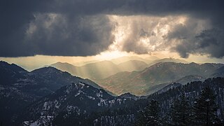
Nathia Gali or Nathiagali is a hill station and mountain resort town located in the Abbottabad District of Khyber Pakhtunkhwa, Pakistan. It is located at the centre of the Galyat range, where several hill stations are situated. Nathia Gali is known for its scenic beauty, hiking tracks and pleasant weather, which is much cooler than the rest of the Galyat range due to it being at a higher altitude. It is situated approximately 32 kilometres (20 mi) away from both Murree and Abbottabad.
Galyat region, or hill tract, is a narrow strip or area roughly 50–80 km north-east of Islamabad, Pakistan, extending on both sides of the Khyber Pakhtunkhwa-Punjab border, between Abbottabad and Murree. The word itself is derived from the plural of the Urdu word gali, which means an alley between two mountains on both sides of which there are valleys and it is not the highest point in the range. Many of the towns in the area have the word gali as part of their names, and are popular tourist resorts. Being on linguistic and geographical continuum this area has challenged social scientists in terms of anomalous classification.

Murree is a mountain resort town, located in the Galyat region of the Pir Panjal Range, within the Muree District of Punjab, Pakistan. It forms the outskirts of the Islamabad-Rawalpindi metropolitan area, and is about 30 km (19 mi) northeast of Islamabad. It has average altitude of 2,291 metres (7,516 ft). The British built this town during their rule to escape the scorching heat in the plains of Punjab during the summer.
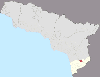
Gali is a town in Abkhazia, Georgia 77 km southeast to Sukhumi. It is the centre of Gali District and was in the United Nations security zone prior to the Russian veto of the UNOMIG Mission in 2009. As of 2011 the town has a population of 7 605 inhabitants.

The Bagh District is one of the tenthDistrict of Azad Kashmir. The district have most famous union council birpani [بیرپانی]due to Hakeem sain Javed and ganga CHOTI, Bagh district which had previously been part of the Poonch District was created in 1988.

The Pir Panjal Range is a group of mountains in the Lesser Himalayan region, running from east-southeast (ESE) to west-northwest (WNW) across the Indian territories of Himachal Pradesh and Jammu and Kashmir and then Pakistan's Azad Kashmir and Punjab. The average elevation varies from 1,400 m (4,600 ft) to 4,100 m (13,500 ft). The Himalayas show a gradual elevation towards the Dhauladhar and Pir Panjal ranges. Pir Panjal is the largest range of the Lesser Himalayas. Near the bank of the Sutlej River, it dissociates itself from the Himalayas and forms a divide between the Beas and Ravi rivers on one side and the Chenab on the other. The renowned Galyat mountains are also located in this range.

Ayubia National Park, also known as Ayubia, is a protected area of 3,312 hectares (33 km2) located in Abbottabad District, Khyber Pakhtunkhwa province, Pakistan. It was declared a national park in 1984. Ayubia was named after Muhammad Ayub Khan (1958–1969), second President of Pakistan. The area supports temperate coniferous forest and temperate broadleaf and mixed forest ecoregion habitats, with an average elevation of 8,000 feet (2,400 m) above sea level. Ayubia National Park is surrounded by seven major villages and three small towns of Thandiani, Nathiagali and Khanspur. The park has been developed as a resort complex from a combination of four mini resorts of Khaira Gali, Changla Gali, Khanspur and Ghora Dhaka in Galyat. Currently, it is managed by the Wildlife and Parks Department of Government of Khyber Pakhtunkhwa.
Takhatgarh is a town in Sumerpur tehsil of Pali District of Rajasthan state in India. The town is one of the nine municipalities in the district, located near the district border. It is only about 160 years old.

Mukshpuri, Mushkpuri, or Mukeshpuri is a 2,800-metre-high (9,200 ft) mountain in the Nathia Gali Hills, in the Circle Bakote Region of Abbottabad District of the Khyber Pakhtunkhwa province in northern Pakistan. It is 90 kilometres (56 mi) north of Islamabad, just above Dunga Gali in the Nathia Gali area of Ayubia National Park. It is the second highest peak in the Galyat Region after Miranjani which is located at 2,992 metres (9,816 ft). Much of the mountain is covered with Western Himalayan subalpine conifer forests.

Miranjani is the highest peak in Galyat Region which is located at the elevation of 2,992 metres (9,816 ft), in Abbottabad District of Khyber Pakhtunkhwa the Province of Pakistan. It is located in the Namli Maira area, in Ayubia National Park, 80 kilometres (50 mi) north of Islamabad in the western Himalayan range.
Ghora Gali is one of the tourist mountain resort towns of the Galyat area of northern Pakistan. It has an elevation of 1691m and is located in the northeastern tip of the Punjab province of Pakistan. Ghora Gali is also a Union council, an administrative subdivision, of Murree Tehsil in Rawalpindi District and is located at 33.83°N 73.35°E. According to the 1998 census of Pakistan it had a population of 14410.
Bara Gali is one of the mountain resort towns of the Galyat and Ayubia National Park, at an altitude of 2,350 metres (7,710 ft). It is located in the Abbottabad District of Khyber Pakhtunkhwa province in northern Pakistan.
Khaira Gali is one of the tourist mountain resort towns of the Galyat area of Pakistan, it has an altitude of 2347m. Khaira Gali is located in Palak which is a Union Council of Abbottabad District in Abbottabad province of Pakistan. This hill station was also used as a barricade by the British during the colonial period and during the summer months it was occupied by one of the British mountain batteries, which were stationed at Rawalpindi during the winter. It is also famous for the hexagon manor on the highest elevation of the town.
This is about a mountain resort town in Pakistan. For the Capital of Bangladesh, see Dhaka

Tajwal is one of the 51 union councils of Abbottabad District in Khyber-Pakhtunkhwa province of Pakistan.

Jhika Gali - is a town in Murree tehsil, Rawalpindi District, Punjab, Pakistan. It is located on the Rawalpindi to Murree road and contains many boarding schools
Barian is a town in Punjab (Pakistan). It is located at 33°57'0N 73°23'0E. The town is linked to the city of Abbottabad by a 71 km road via Nathia Gali, the area is often cut off during bad winter weather, in 2005 heavy snowfall had cut the roads to Khanspur and Changla Gali, and in January 2008 snow and heavy landslides cut off roads.

The Pakistan Cycling Federation is the national governing body of cycle racing in Pakistan. It was established in 1947 and is based in Peshawar.
Surankote is a town in the Surankote Tehsil of the Poonch district of the Indian union territory of Jammu and Kashmir. It occupies the Surankote valley, located between the Pir Panjal and ranges within the Himalayas. It receives snowfall in winters. It is famous for the existence of lakes on the Pir Panjal range which are not still connected with the outside world. Although some people visit these lakes by foot for recreation and refreshment.
