Trinidad is the capital city of Flores in southern Uruguay. It has a population of 21,429. Formerly it was called Santísima Trinidad de los Porongos, or simply Porongos. Its inhabitants are known as trinitarios or also as porongueros because the city is located near the Porongos stream.

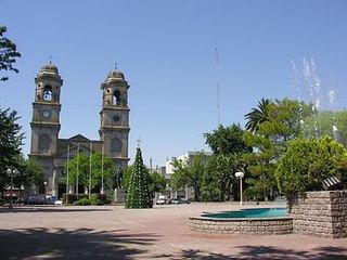
Florida is the capital of Florida Department of Uruguay. Having a population of over 33,000, it is home to almost half of the inhabitants of the department.
El Pinar is a seaside resort of the Canelones Department, Uruguay. In 1994, when Ciudad de la Costa took on the status of a city, El Pinar was incorporated in it.
Chamberlain is a village or populated centre of Tacuarembó Department, in northern Uruguay. It is connected by railway with the city of Paysandú.

Mendoza, or Mendoza Grande, is a village or populated centre in the Florida Department of southern-central Uruguay.
Chacras de Paysandú, which means "Ranches of Paysandú", is a wide but sparsely populated rural area, which is an east and southeast extension of the city of Paysandú in the Paysandú Department of western Uruguay.
El Eucaliptus is a caserío (hamlet) in the centre of Paysandú Department, in western Uruguay.
Gallinal is a caserío (hamlet) in the Paysandú Department of western Uruguay.
San Félix is a village or populated centre in the Paysandú Department of western Uruguay. It is a southern suburb of the city of Paysandú and it contains the horse race tracks of the city, the Hipódromo San Felix.
Piedras Coloradas is a village or populated centre in the south of Paysandú Department in western Uruguay.
Nuevo Paysandú is a northern suburb of Paysandú in the Paysandú Department of western Uruguay.
Orgoroso is a village or populated centre in the Paysandú Department of western Uruguay.
Lapuente is a village, or populated centre, in the Rivera Department of northeastern Uruguay.
Villa Darwin is a village or populated centre in the Soriano Department of western Uruguay.
Las Toscas is a village or populated centre in the Tacuarembó Department of northern-central Uruguay.

Paso Bonilla is a village or populated centre in the Tacuarembó Department of northern-central Uruguay.
Paso del Cerro is a village or populated centre in the Tacuarembó Department of northern-central Uruguay.
Barrio Anglo is a village in the Río Negro Department of Uruguay.
San Rafael – El Placer is a resort in the Maldonado Department of southeastern Uruguay.
Arroyo Chapicuy Grande is a river located in western Uruguay.


