San Javier (Сан-Хавьер) is a town situated on the east bank of the river Río Uruguay in the Río Negro Department of Uruguay. It was founded in 1913 by a Russian group of settlers, members of the New Israel religious sect, who migrated under the influence of the then spiritual leader Vasily Lubkov, from the Voronezh region of Russia.
Young is a city in the centre of the Río Negro Department of Uruguay.

Tala is a town in the north of the Canelones Department of southern Uruguay.
Quebracho is a small town (villa) in Paysandú Department in Uruguay.

Tarariras, is a small city in the south of the Colonia Department of southern Uruguay.

Cerrillos or Los Cerrillos is a very small city in the west part of the Canelones Department of southern Uruguay.

San Jacinto is a small city in the Canelones Department of southern Uruguay.
Ombúes de Lavalle is a small city located in the north of Colonia Department in southwestern Uruguay. It is named after the Argentine General Juan Lavalle. The term «Ombúes» is the Spanish plural for «Ombú», a tree originary of the Pampas region, in southern South America, and a national symbol of both Argentina and Uruguay.
Isidoro Noblía is a small town (villa) in the Cerro Largo Department of eastern Uruguay.

Blanquillo is a village in the Durazno Department of central Uruguay.
Merinos is a village in the south of Paysandú Department of western Uruguay.

Vichadero is a small village in the Rivera Department of northeastern Uruguay.
Ecilda Paullier is a small town in the San José Department of southern Uruguay.
Rodríguez is a small town (villa) in the San José Department of southern Uruguay.

José Enrique Rodó is a small town in the Soriano Department of western Uruguay.
Tambores is a small town partly in the Paysandú Department and partly in the Tacuarembó Department of western Uruguay.

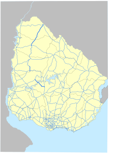
Route 4 is a national route of Uruguay. In 1975, it was assigned the name Andrés Artigas, a national hero of Uruguay. One fragment of it splits off Route 5 at Carlos Reyles of Durazno Department and ends at Route 20 in Río Negro Department, while a longer part starts off Route 90 in Paysandú Department near Guichón and connects with the city of Artigas in the north. The two parts are of a total length of approximately 330 kilometres (210 mi).
Rafael Perazza is a village in the San José Department of southern Uruguay.
Grecco is a village in the Río Negro Department of Uruguay.
Cañada Nieto is a village in the Soriano Department of southwestern Uruguay.


