Chatterbox Falls

Last updated
Chatterbox Falls
Chatterbox Falls close-up.jpg
Chatterbox Falls, Princess Louisa Inlet
Chatterbox Falls
LocationMouth of Losquilts Creek at head of Princess Louisa Inlet, NE end of Jervis Inlet, New Westminster Land District
Coordinates 50°12′22″N123°46′14″W / 50.2061°N 123.7706°W / 50.2061; -123.7706
Type Fan
Total height120 feet (37 m)
WatercourseLoquilts Creek

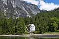
Chatterbox Falls is a waterfall in British Columbia, Canada, located at the head or end of Princess Louisa Inlet. [1] It is part of Loquilts River which empties into the inlet. The falls are a popular destination for boaters around the world and are in Princess Louisa Marine Provincial Park, part of BC Parks' marine park system which manages the area with the cooperation of the Princess Louisa International Society.

Contents

Just upstream from Chatterbox Falls lies the 2,755-foot (840 m) James Bruce Falls, which is the tallest waterfall in North America. [2]

See also

Related Research Articles

<span class="mw-page-title-main">Yoho National Park</span> National park in British Columbia, Canada

Yoho National Park is a national park of Canada. It is located within the Rocky Mountains along the western slope of the Continental Divide of the Americas in southeastern British Columbia, bordered by Kootenay National Park to the south and Banff National Park to the east in Alberta. The word Yoho is a Cree expression of amazement or awe, and it is an apt description for the park's spectacular landscape of massive ice fields and mountain peaks, which rank among the highest in the Canadian Rockies.

Chatterbox may refer to:

<span class="mw-page-title-main">Della Falls</span> Waterfall on Della Creek in Strathcona Provincial Park, British Columbia, Canada

Della Falls is a waterfall located within Strathcona Provincial Park on Vancouver Island in British Columbia, Canada. With a total height of 440 m (1,440 ft), it ranks as the 16th tallest confirmed waterfall in Canada and the second tallest on Vancouver Island after Kiwi Falls in Schoen Lake Provincial Park.

<span class="mw-page-title-main">Bridal Veil Falls Provincial Park</span> Provincial park

Bridal Veil Falls Provincial Park is a BC Park located on the Trans-Canada Highway just east of Rosedale, British Columbia, Canada, part of the City of Chilliwack. The community of Bridal Falls is located adjacent to the falls and park as well as the interchange between the Trans-Canada and BC Highway 9 and has a variety of highway-based tourism services. Access to the falls requires a short hike from the parking lot and well groomed trails, taking most groups 15-25 minutes.

<span class="mw-page-title-main">Jervis Inlet</span> Inlet in British Columbia, Canada

Jervis Inlet is one of the principal inlets of the British Columbia Coast, about 95 km (59 mi) northwest of Vancouver, and the third of such inlets north of the 49th parallel, the first of which is Burrard Inlet, Vancouver's harbour.

<span class="mw-page-title-main">Klewnuggit Inlet Marine Provincial Park</span> Provincial park in British Columbia, Canada

Klewnuggit Inlet Marine Provincial Park is a provincial park in British Columbia, Canada, located on the east side of Grenville Channel, 100 kilometres (62 mi) southeast of Prince Rupert, in the Range 4 Coast Land District.

<span class="mw-page-title-main">Little Qualicum Falls Provincial Park</span> Provincial park in British Columbia, Canada

Little Qualicum Falls Provincial Park is a provincial park in British Columbia, Canada, on central Vancouver Island, that encompasses the entire southern shore of Cameron Lake. The Island Rail Corridor line to Port Alberni passes through the park.

Princess Louisa Marine Provincial Park is a provincial park in British Columbia, Canada surrounding Princess Louisa Inlet.

Schoen Lake Provincial Park is a provincial park in northeastern Vancouver Island, British Columbia, Canada, located east of the community of Woss Lake and southwest of Sayward. The park lies inside the Nimpkish Valley watershed. On October 28, 1977, the "Class A" park was officially created to protect, exhibit and interpret an example of the natural features and processes of the Insular Mountains Natural Region. The park covers a total area of 8,775 hectares. Within those hectares of park land is a number of lakes, creeks and mountain ranges.

<span class="mw-page-title-main">Shannon Falls Provincial Park</span> Provincial park in British Columbia, Canada

Shannon Falls Provincial Park is a provincial park in British Columbia, Canada. It is located 58 kilometers (36 mi) from Vancouver and 2 kilometers (1.2 mi) south of Squamish along the Sea to Sky Highway.

<span class="mw-page-title-main">Indian Arm</span> Fjord in British Columbia

Indian Arm is a steep-sided glacial fjord adjacent to the city of Vancouver in southwestern British Columbia. Formed during the last Ice Age, it extends due north from Burrard Inlet, between the communities of Belcarra and the District of North Vancouver, then on into mountainous wilderness. Burrard Inlet and the opening of Indian Arm was mapped by Captain George Vancouver and fully explored days later by Dionisio Alcalá Galiano in June 1792.

<span class="mw-page-title-main">Princess Louisa Inlet</span>

Princess Louisa Inlet is a fjord on British Columbia’s Sunshine Coast and within the swiya of the shíshálh Nation.

<span class="mw-page-title-main">Alberni Valley</span> Valley in British Columbia, Canada

Alberni Valley is a broad valley located at the head of Alberni Inlet on Vancouver Island in British Columbia, Canada. It is home to Port Alberni, Sproat Lake and other outlining areas. The term is largely used as a synonym for Greater Port Alberni and adjoining communities but is used in a larger regional sense as well. Various local organizations and companies use the term "Alberni Valley" in their name, e.g. the Alberni Valley Times and Alberni Valley News newspapers the Alberni Valley Chamber of Commerce and the Alberni Valley Bulldogs minor hockey team. The Canadian pioneer, Joe Drinkwater lived in Alberni Valley during the late nineteenth and early twentieth centuries.

<span class="mw-page-title-main">Mount Alfred</span> Mountain in British Columbia, Canada

Mount Alfred is a mountain located at the Queen Reach arm and head of the Jervis Inlet within the Pacific Ranges of the Coast Mountains in British Columbia, Canada. The mountain is the highest in the portion of the mainland between Jervis and Toba Inlets, with its 1,318 metres (4,324 ft) prominence defined by the pass at the head of the Skwawka River, which feeds the head of Jervis Inlet. The unofficially-named Alfred Creek Falls, on Alfred Creek which drains off the mountain's glaciers southeast into the Skwawka, is one of Canada's highest waterfalls at 700 metres (2,297 ft).

Hotham Sound is a sidewater of Jervis Inlet on the South Coast of British Columbia, Canada, located near the mouth of that inlet on the north flank of its lower reaches, roughly opposite the mouth of Sechelt Inlet. There is a deep basin at its entrance reaching a depth of 730 m (2,400 ft). Harmony Islands Marine Provincial Park is located on the east side of Hotham Sound. The spectacular Harmony Falls, also called Freil Lake Falls, plunges a total of 444 m (1,457 ft) into the Sound.

<span class="mw-page-title-main">James Bruce Falls</span> Waterfall in British Columbia, Canada. Tallest measured in North America by overall height.

James Bruce Falls is a waterfall in British Columbia, Canada, the highest-measured waterfall of North America and ninth-tallest in the world.

<span class="mw-page-title-main">Malibu Islet</span>

Malibu Islet, also known as Malibu Isle or Forbidden Island, is located at the entrance of Princess Louisa Inlet, south of Malibu Rapids, east of Queens Reach, a stretch of Jervis Inlet in the New Westminster Land District, British Columbia, Canada. The island is the part of the narrow passage that joins Princess Louisa Inlet and Jervis Inlet together. The navigational entrance to Princess Louisa Inlet for all marine traffic is between the island and a navigation buoy.

<span class="mw-page-title-main">Salmon Inlet</span>

Salmon Inlet, formerly Salmon Arm, is a fjord branching east from Sechelt Inlet in the British Columbia, Canada. Its companion, Narrows Inlet, another side-inlet of Sechelt Inlet, lies roughly 10 km (6.2 mi) north. Misery and Sechelt Creeks flow freely into the inlet, while the Clowhom River flows in from the artificial Clowhom Lake, formed by a small hydroelectric power development. The fjord is 23 km (14 mi) long; Clowhom Lake, covering a waterfall on the Clowhom River, stretches a further 12 km (7.5 mi) to the western base of Mount Tantalus, which is best known from the direction of Squamish and the Cheakamus Canyon stretch of British Columbia Highway 99. Heavily affected by logging and milling operations, the inlet is split almost into two portions by an alluvial fan spreading from the mouth of Sechelt Creek.

<span class="mw-page-title-main">Hunlen Falls</span> Waterfall on Hunlen Creek in Tweedsmuir South Provincial Park, British Columbia, Canada

Hunlen Falls is a waterfall located at the mouth of Turner Lake in the Pacific Ranges of British Columbia, Canada. With an estimated height of 260 m (850 ft), it is tied with Takakkaw Falls in Yoho National Park for having the fourth tallest single drop of any waterfall in Canada.

References

  1. "Chatterbox Falls". Geographical Names Data Base . Natural Resources Canada.
  2. "Tallest and Largest Waterfalls". www.worldwaterfalldatabase.com. World Waterfall Database. Retrieved 19 June 2019.