Related Research Articles

A drainage basin is an area of land where all flowing surface water converges to a single point, such as a river mouth, or flows into another body of water, such as a lake or ocean. A basin is separated from adjacent basins by a perimeter, the drainage divide, made up of a succession of elevated features, such as ridges and hills. A basin may consist of smaller basins that merge at river confluences, forming a hierarchical pattern.

An endorheic basin is a drainage basin that normally retains water and allows no outflow to other, external bodies of water ; instead, the water drainage flows into permanent and seasonal lakes and swamps that equilibrate through evaporation. Endorheic basins are also called closed basins, terminal basins, and internal drainage systems.
The African Great Lakes are a series of lakes constituting the part of the Rift Valley lakes in and around the East African Rift. The series includes Lake Victoria, the second-largest freshwater lake in the world by area; Lake Tanganyika, the world's second-largest freshwater lake by volume and depth; Lake Malawi, the world's eighth-largest freshwater lake by area; and Lake Turkana, the world's largest permanent desert lake and the world's largest alkaline lake. Collectively, they contain 31,000 km3 (7,400 cu mi) of water, which is more than either Lake Baikal or the North American Great Lakes. This total constitutes about 25% of the planet's unfrozen surface fresh water. The large rift lakes of Africa are the ancient home of great biodiversity, and 10% of the world's fish species live in this region.

The Columbia River drainage basin is the drainage basin of the Columbia River in the Pacific Northwest region of North America. It covers 668,000 km2 or 258,000 sq mi. In common usage, the term often refers to a smaller area, generally the portion of the drainage basin that lies within eastern Washington.

Tabora is the capital of Tanzania's Tabora Region and is classified as a municipality by the Tanzanian government. It is also the administrative seat of Tabora Urban District. According to the 2012 census, the district had a population of 226,999.

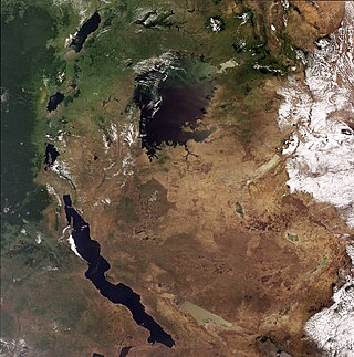
Kigoma Region is one of Tanzania's 31 administrative regions, with the city of Kigoma as the reigonal capital. Kigoma Region borders Kagera Region, Geita Region, Katavi Region, Tabora Region, DRC and Burundi According to the 2012 national census, the region had a population of 2,127,930, which was higher than the pre-census projection of 1,971,332. For 2002–2012, the region's 2.4 percent average annual population growth rate was tied for the fourteenth highest in the country. It was also the sixteenth most densely populated region with 57 people per square kilometer. With a size of 45,066 square kilometres (17,400 sq mi), the region is slightly smaller than Estonia.

Mbeya Region is one of Tanzania's 31 administrative regions. The region covers an area of 35,954 km2 (13,882 sq mi). The region is comparable in size to the combined land area of the nation state of Guinea Bissau. Mbeya Region is bordered to the east by Singida Region, Iringa Region and Njombe Region. The region is bordered to the south by Malawi and Lake Nyasa. To the north the region borders southern Tabora Region. Lastly, Mbeya is bordered to the west by Songwe Region. The regional capital is the city of Mbeya. According to the 2022 national census, the region had a population of 2,343,754.

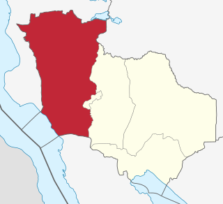
Tabora Region is one of Tanzania's 31 administrative regions located in mid-western part of Tanzania. The regional capital is the municipality of Tabora. Tabora is bordered by Shinyanga to the north, Singida to the east, Mbeya and Songwe to the south. lastly, Katavi, Kigoma and Geita, border Tabora to the west. Tabora is by far the largest region in Tanzania by area. Most of the population in the region is concentrated in the north in Nzega district. According to the 2022 national census, Tabora Region had a population of 3,391,679.
Mpanda District is one of the five districts of the Katavi Region of Tanzania. Its administrative seat is the city of Mpanda. The district is bordered to the northwest by the Kigoma Region, to the northeast by the Tabora Region, to the east by the Mbeya Region, to the southeast by the Sumbawanga Urban District, to the southwest by the Nkasi District and to the west by Lake Tanganyika.

The Great Ruaha River is a river in south-central Tanzania that flows through the Usangu wetlands and the Ruaha National Park east into the Rufiji River. It traverses and marks the borders between Iringa Region, Dodoma Region and Morogoro Region. The Great Ruaha river has a basin catchment area of 83,970 square kilometres (32,421 sq mi). The population of the basin is mainly sustained by irrigation and water-related livelihoods such as fishing and livestock keeping.
The Sibiti River is a seventy-five-kilometre waterway which connects Lake Eyasi and Lake Kitangiri, and one of the few non-man-made canals in the world. The river is a natural border between Singida Region and Simiyu Region In northcentral Tanzania.

As a body of water that crosses numerous international political borders, the Nile river is subject to multiple political interactions. Traditionally it is seen as the world's longest river flowing 6,700 kilometres (4,200 mi) through ten countries in northeastern Africa – Rwanda, Burundi, Democratic Republic of the Congo (DRC), Tanzania, Kenya, Uganda, Ethiopia, South Sudan, Sudan and Egypt with varying climates.
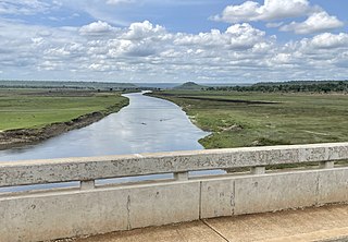
The Malagarasi River is a river in western Tanzania, flowing through Kigoma Region, although one of its tributaries comes from southeastern Burundi. The river also forms the western border of Tabora Region, the southern border of Kagera Region and the southwestern border of Geita Region. It is the second-longest river in Tanzania behind the Rufiji—Great Ruaha, and has the largest watershed of any river flowing into Lake Tanganyika. The Malagarasi-Muyovozi Wetlands are a designated a Ramsar site. Local tribes have nicknamed the Malagarasi as "the river of bad spirits".

The Nile Basin Initiative (NBI) is a partnership among the Nile riparian states that “seeks to develop the river in a cooperative manner, share substantial socioeconomic benefits, and promote regional peace and security”. The NBI began with a dialogue among the riparian states that resulted in a shared vision objective “to achieve sustainable socioeconomic development through the equitable utilization of, and benefit from, the common Nile Basin water resources." It was formally launched in February 1999 by the water ministers of nine countries that share the river: Egypt, Sudan, Ethiopia, Uganda, Kenya, Tanzania, Burundi, Rwanda, the Democratic Republic of Congo (DRC), as well as Eritrea as an observer. From its beginning the Nile Basin Initiative has been supported by the World Bank and by other external partners. The World Bank has a mandate to support the work of the NBI, as lead development partner and as administrator of the multi-donor Nile Basin Trust Fund. One of the partners is the "Nile Basin Discourse", which describes itself as "a civil society network of organisations seeking to achieve positive influence over the development of projects and programmes under the Nile Basin Initiative".

Water supply and sanitation in Tanzania is characterised by: decreasing access to at least basic water sources in the 2000s, steady access to some form of sanitation, intermittent water supply and generally low quality of service. Many utilities are barely able to cover their operation and maintenance costs through revenues due to low tariffs and poor efficiency. There are significant regional differences and the best performing utilities are Arusha and Tanga.

The Nile Basin is the part of Africa drained by the Nile River and its tributaries.

The Pangani River, is a major river of northeastern Tanzania. It has two main sources: the Ruvu, which rises as Lumi at Kilimanjaro, passes through Lake Jipe, and empties into the Nyumba ya Mungu Reservoir, and the Kikuletwa River, coming from the west and mainly fed by rivers of Mount Meru in Arusha Region, which also enters into the Nyumba ya Mungu Reservoir in Kilimanjaro Region. Just after leaving the reservoir the stream becomes the main Pangani, which empties into the Indian Ocean in Tanga Region at the Tangan port town of Pangani.
References
- ↑ "Cheli, Tabora Region, Tanzania". Mindat.com.
- ↑ Water Resources Fact Sheet The Internal Drainage Basin, The United Republic of Tanzania, Ministry of Water Water Resources Division.