
Dar es Salaam is the largest city and financial hub of Tanzania. It is also the capital of the Dar es Salaam Region. With a population of over nine million people, Dar es Salaam is the largest city in East Africa by population and the sixth-largest in Africa. Located on the Swahili coast, Dar es Salaam is an important economic center and one of the fastest-growing cities in the world.

Kariakoo is an administrative ward of the Ilala Municipal Council of the Dar es Salaam Region in Tanzania. Jangwani ward and Mchafukoge ward form the ward's northern and eastern boundaries. The Gerezani and Mchikichini wards border the ward to the south and west respectively. The ward is the home of Simba Sports Club. The name is derived from the swahilization of the British colonial occupation's "Carrier Corps", that used to be based in the area. Today, Kariakoo is mainly known for its large market that spans several city blocks. According to the 2022 census, the ward has a population of 10,246.

The Awash River is a major river of Ethiopia. Its course is entirely contained within the boundaries of Ethiopia and empties into a chain of interconnected lakes that begin with Lake Gargori and end with Lake Abbe on the border with Djibouti, some 100 kilometres from the head of the Gulf of Tadjoura. The Awash River is the principal stream of an endorheic drainage basin covering parts of the Amhara, Oromia and Somali Regions, as well as the southern half of the Afar Region. The Awash River basin, spanning 23 administrative zones, covers 10% of Ethiopia's area.

Dar es Salaam Region is one of Tanzania's 31 administrative regions and is located in the east coast of the country. The region covers an area of 1,393 km2 (538 sq mi). The region is comparable in size to the combined land and water areas of the nation state of Mauritius. Dar es Salaam Region is bordered to the east by Indian Ocean and it is entirely surrounded by Pwani Region. The Pwani districts that border Dar es Salaam region are Bagamoyo District to the north, Kibaha Urban District to the west, Kisarawe District to the south west and Mkuranga District to the south of the region. The region's seat (capital) is located inside the ward of Ilala. The region is named after the city of Dar es Salaam itself. The region is home to Tanzania's major finance, administration and industries, thus the making it the country's richest region. The region also has the second highest Human Development Index in the country after Mjini Magharibi. According to the 2022 census, the region has a total population of 5,383,728. The region has the highest population in Tanzania followed by Mwanza Region.

The Mayo Kébbi is a river in Central and West Africa. The river rises in Chad, then flows west into the Bénoué River. Mayo-Kébbi Prefecture in Chad is named for it. The Mayo Kébbi is the major outlet for Lake Fianga, shared between Cameroon and Chad.

Kinondoni District, officially the Kinondoni Municipal Council is one of five districts of the Dar es Salaam Region of Tanzania. The district is bordered to the north by Bagamoyo District and Kibaha of Pwani Region, to the east by the Indian Ocean, the west by Ubungo District, and to the south by the Ilala District. The district covers an area of 269.5 km2 (104.1 sq mi). The district is comparable in size to the land area of Malta. The administrative seat is Ndugumbi. The district is home to one of the best preserved Medieval Swahili settlements, Kunduchi Ruins, headquarters for the National Muslim Council of Tanzania (BAKWATA) and Makumbusho Village Museum. Considered the cultural center of Dar es Salaam, Kinondoni District is also regarded the birthplace of the musical genre of Singeli. In addition the district is one of two districts in Dar es Salaam that has a National Historic Site, namely the Kunduchi Ruins. The 2012 National Tanzania Census states the population for Kinondoni as 1,775,049.

Ilala District, officially the Ilala Municipal Council is one of five districts of the Dar es Salaam Region of Tanzania. The district is bordered to the north and northeast by Kinondoni District and Ubungo District, to the east by the Zanzibar Channel, the west by Pwani Region, and to the south by the Temeke District. It covers an area of 364.9 km2 (140.9 sq mi). The district is comparable in size to the land area of U.S Virgin Islands. The administrative seat is Mchafukoge. The 2022 National Tanzania Census states the population for Ilala as 1,649,912.

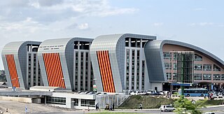
Ubungo District, officially the, Ubungo Municipal Council is one of five districts of the Dar es Salaam Region of Tanzania. The Kinondoni District and Kibaha of the Pwani Region border the district to the north; the Kisarawe District of Pwani Region borders it to the west; and the Ilala District borders the it to the south and east. The district covers an area of 269.4 km2 (104.0 sq mi). The district is comparable in size to the land area of St. Kitts and Nevis. The administrative seat is Kwembe. The district is home to the University of Dar es Salaam, The Magufuli Bus Terminal, the largest in the country, and Pande Game Reserve the largest protected land area in Dar es Salaam Region. In addition, the district is home to the largest natural gas powered power station, the Ubungo Thermal Power Station and the headquarters of the Tanzania Electric Supply Company Limited (TANESCO). The 2022 census states the population of the district as 1,086,912.
Mkuranga District Council is one of eight administrative districts of Pwani Region in Tanzania. The District covers an area of 2,827 km2 (1,092 sq mi). It is bordered to the north by Dar es Salaam's Kigamboni, Temeke and Ilala Districts. To the east by the Mafia Channel, to the south by Kibiti District, and to the west by Kisarawe District. The district is comparable in size to the land area of Samoa. The town of Mkuranga serves as its administrative capital. The district is home to the Vikindu Forest Reserve, one of last remaining East African coastal forests. In 2016 the Tanzania National Bureau of Statistics report the population of Mkuranga District were 243,062 people in the district, from 222,921 in 2012.
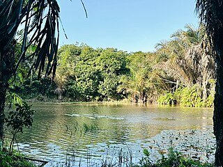
Mbezi is an administrative ward in Ubungo District of the Dar es Salaam Region in Tanzania. Mabwepande and Wazo of Kinondoni MC border the ward to the north. The ward is bordered to the east by the wards of Saranga and Goba. South of here is Msigani. The westernmost wards are Kwembe, Kibamba, Maili Moja, and Pangani, the latter two of Kibaha. The ward is home to the majority of Pande Game Reserve's area. The ward is named after the Mbezi River, which passes through it. According to the 2012 census, the ward has a total population of 73,414.

Ilala or Ilala Ward is an administrative ward of the Ilala District of the Dar es Salaam Region in Tanzania. The Kigogo ward of the Kinondoni District borders the ward to the north, and the Mchikichini and Gerezani wards to the east. The Temeke District wards of Keko, Chang'ombe, and Temeke border the ward to the south. Buguruni encircles the ward to the west. In 2022, the population of the ward was 23,787.
Tanzania, officially known as the United Republic of Tanzania, is a mid-sized country in southeastern Africa bordering the Indian Ocean. It is home to a population of about 43.1 million people. Since gaining its independence from the United Kingdom in 1961, Tanzania has been continuously developing in terms of its economy and modern industry. However, the country’s economic success has been limited. Environmental obstacles, such as the mismanagement of natural resources and industrial waste, have been contributing factors and results of the relatively low economic status of the country. Tanzania’s annual output still falls below the average world GDP. In 2010, the GDP for Tanzania was US $23.3 billion and the GDP per capita was US $1,515. Comparatively, the GDP for the United States was $15.1 trillion and the GDP per capita was approximately $47,153. Eighty percent of the workers accounting for this annual output in Tanzania work in agriculture, while the remaining 20% work in industry, commerce, and government organizations. Such a heavy reliance on agriculture has placed a huge amount of strain on an already limited supply of viable land.
Ramani Huria is community-based mapping project in Dar Es Salaam, Tanzania, training university students and local community members to create highly accurate maps of the most flood-prone areas of the city using OpenStreetMap.

A field is a mineral deposit containing a metal or other valuable resources in a cost-competitive concentration. It is usually used in the context of a mineral deposit from which it is convenient to extract its metallic component. The deposits are exploited by mining in the case of solid mineral deposits and extraction wells in case of fluids.

Magufuli Bus Terminal also unofficially known as Mbezi Bus Terminal is a major bus terminal located in Mbezi ward of Ubungo District of Dar es Salaam Region in Tanzania.

The chromium cycle is the biogeochemical cycle of chromium through the atmosphere, hydrosphere, biosphere and lithosphere.

The lead cycle is the biogeochemical cycle of lead through the atmosphere, lithosphere, biosphere, and hydrosphere, which has been influenced by anthropogenic activities.
The Pande Game Reserve is a protected area located in Mabwepande ward of Kinondoni District and Mbezi ward of Ubungo District in Dar es Salaam Region of Tanzania that covers an area of 15.39 km2 (5.94 sq mi). It was established as a Forest Reserve in 1952 under the British colonial occupation.
Mpiji River is located in the north east of Pwani Region and western Dar es Salaam Region of Tanzania. It begins in Masaki ward in Kisarawe District and eventually drains into Zanzibar Channel at the border of Mbweni ward of Kinondoni MC of Dar es Salaam and Kerege ward of Bagamoyo District of Pwani Region.
Msimbazi River is located in Dar es Salaam Region of Tanzania. It begins in Kisarawe ward, Kisarawe District and eventually drains into Zanzibar Channel at the border of Upanga West ward of Ilala MC and Hananasif ward of Kinondoni MC. The length of the Msimbazi River is about 35 kilometers. It flows eastward into the Zanzibar Channel of the Indian Ocean via the Pugu and Kazimzumbwi Forest Reserves, joining the Sinza, Ubungo, and Luhanga Rivers along the way.
