Jelep La elevation 14,390 feet (4,390 m), is a high mountain pass between Sikkim, India and Tibet Autonomous Region, China. It is on a route that connects Lhasa to India. The pass is about 4 km (2.5 mi) south of Nathu La and is slightly higher. It was frequently used for trade between Tibet and India during the British Raj, with Kalimpong serving as the contact point. The Menmecho Lake lies below the Jelep La.

Nathu La(Tibetan: རྣ་ཐོས་ལ་, Wylie: Rna thos la, THL: Na tö la, Sikkimese: རྣ་ཐོས་ལ་) is a mountain pass in the Dongkya Range of the Himalayas between China's Yadong County in Tibet, and the Indian states of Sikkim. But minor touch of Bengal in South Asia. The pass, at 4,310 m (14,140 ft), connects the towns of Kalimpong and Gangtok to the villages and towns of the lower Chumbi Valley.
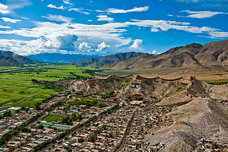
Gyantse, officially Gyangzê Town, is a town located in Gyantse County, Shigatse Prefecture, Tibet Autonomous Region, China. It was historically considered the third largest and most prominent town in the Tibet region, but there are now at least ten larger Tibetan cities.

Yadong County, also known by its Tibetan name Dromo/TromoCounty is a frontier county and trade-market of the Tibet Autonomous Region of China, part of its Shigatse Prefecture.

The Chumbi Valley, called Dromo or Tromo in Tibetan, is a valley in the Himalayas that projects southwards from the Tibetan plateau, intervening between Sikkim and Bhutan. It is coextensive with the administrative unit Yadong County in the Tibet Autonomous Region of China. The Chumbi Valley is connected to Sikkim to the southwest via the mountain passes of Nathu La and Jelep La.

The British expedition to Tibet, also known as the Younghusband expedition, began in December 1903 and lasted until September 1904. The expedition was effectively a temporary invasion by British Indian Armed Forces under the auspices of the Tibet Frontier Commission, whose purported mission was to establish diplomatic relations and resolve the dispute over the border between Tibet and Sikkim. In the nineteenth century, the British had conquered Burma and Sikkim, with the whole southern flank of Tibet coming under the control of the British Indian Empire. Tibet ruled by the Dalai Lama under the Ganden Phodrang government was a Himalayan state under the protectorate of the Chinese Qing dynasty until the 1911 Revolution, after which a period of de facto Tibetan independence (1912–1951) followed.

Yatung or Yadong, also known as Shasima , is the principal town in the Chumbi Valley or Yadong County in the Tibet Autonomous Region of China. It is also its administrative headquarters.
Bji Gewog is a gewog of Haa District, Bhutan. It is the northernmost gewog of the Haa District, bordering China's Chumbi Valley. The gewog has mostly mountainous terrain, with rivers flowing into Amo Chu in the west and the Ha Chu in the east. China claims a large part of the gewog as its territory and has recently started building roads and villages in the border areas.
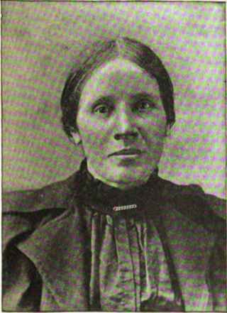
Hannah Royle Taylor, known as Annie Royle Taylor, was an English explorer and Evangelical missionary to Tibet. She was the first Western woman known to have visited Tibet. She attempted to reach the "forbidden" city of Lhasa in 1892–1893.

The Sikkim expedition was an 1888 British military expedition to expel Tibetan forces from the Kingdom of Sikkim. The roots of the conflict lay in British–Tibetan competition for suzerainty over Sikkim.

The Convention of Lhasa, officially the Convention Between Great Britain and Thibet, was a treaty signed in 1904 between Tibet and Great Britain, in Lhasa, the capital of Tibet, then a protectorate of the Qing dynasty. It was signed following the British expedition to Tibet of 1903–1904, a military expedition led by Colonel Francis Younghusband, and was followed by the Anglo-Chinese Convention of 1906.

John Claude White was an engineer, photographer, author and civil servant in British India. From 1889 to 1908, White was the political officer in Sikkim, then a British protectorate. As part of his remit, he also managed British India's relations with Tibet and Bhutan.
Cho La or Cho-la is a mountain pass in the Chola range of the Himalayas. It connects the Indian state of Sikkim with China's Tibet Autonomous Region. It is situated around four miles to the north-west of Nathu La.

Gipmochi is a mountain in the Lower Himalayas in south central Asia. Rising to a height of 14,523 feet (4,427 m), the mountain sits on the border between the northern Indian state of Sikkim and Bhutan. China claims Gipmochi as the China–India–Bhutan tri-junction point. Bhutan and India, however, claim that the tri-junction is 6.5 km to the north, at Batang La.

Doklam, called Donglang by China, is an area in Bhutan with a high plateau and a valley, lying between China's Chumbi Valley to the north, Bhutan's Ha District to the east and India's Sikkim state to the west. It has been depicted as part of Bhutan in the Bhutanese maps since 1961, but it is also claimed by China. The dispute has not been resolved despite several rounds of border negotiations between Bhutan and China. The area is of strategic importance to all three countries.

Chumbi is a historic village in the Chumbi Valley or the Yadong County of the Tibet Autonomous Region of China. It is in the valley of Amo Chu river, where the route from Sikkim's Cho La pass meets the Amo Chu valley. The "Chumbi Valley" of the European nomenclature derives its name from the village of Chumbi. It was the administrative center of the lower Chumbi Valley until the Chinese take-over of Tibet in 1950, after which Yatung became its headquarters. Chumbi is also associated with the Sikkim's royal family, which had a summer palace in the village.
Rinchengang (Tibetan: རིན་ཆེན་སྒང, Wylie: rin chen sgang, THL: rin chen gang, ZYPY: Rinqêngang) or Renqinggang (Chinese: 仁青岗村; pinyin: Rén qīng gǎng cūn) is a town in the Chumbi Valley and the headquarters of the Xia Yadong Township of Yadong County, Tibet region of China. It is in the valley of Amo Chu where the route from Sikkim's Jelep La pass meets Amo Chu. It is also close to the Bhutan–China border, which is currently in dispute. In December 2018, Rinchengang village had a population of around 550 people. The inhabitants are engaged in animal grazing or work as forest rangers. Some also carry supplies to Chinese border troops.
Xiayadong Township, known in Tibetan as Dromo Mechü is a township in the Chumbi Valley in Yadong County, Shigatse, in the Tibet Autonomous Region of China. Much of the township's area comprises disputed territory: the township spans an area of 204.7 square kilometres (79.0 sq mi), excluding disputed territory, and 650.88 square kilometres (251.31 sq mi) including it. Xiayadong Township's population totaled 897 as of 2018.
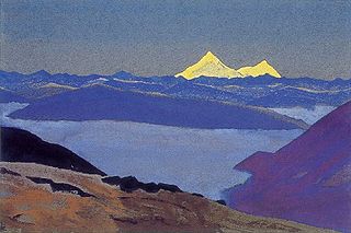
Dongkya or Dongkhya range, is a mountain range in the lower Himalayas that forms the eastern border of Sikkim, a state of India. Its northern tip extends to Dongkha La, and as it moves southwards, sometimes referred to as the Chola range, it is cut by Cho La, Yak La, Nathu La and Jelep La passes.

Old Yatung, originally just "Yatung", with a native Tibetan spelling of Nyatong or Myatong, is a location 2 miles west of Rinchengang in the lower Chumbi Valley in the present day Yadong County of Tibet. It is in the valley of Yatung Chu, the river that flows down from Jelep La to join the Amo Chu river near Rinchengang. But according to travel writer John Easton, Yatung is actually a hill top location adjoining the valley, which has a historic Kagyu monastery. The monastery itself lies along the route from the Nathu La pass via Champithang.


