Chena, Alaska

Last updated

Chena, Alaska
Ghost Town
View of Chena on the Tanana River, 1907 (AL+CA 84).jpg
View of Chena on the Tanana River, 1907
USA Alaska location map.svg
Red pog.svg
Chena
Location in the U.S. state of Alaska
Coordinates(USGS GNIS 1893892): 64°47′44″N147°57′06″W / 64.79556°N 147.95167°W / 64.79556; -147.95167
CountryUnited States
State Alaska
Borough Fairbanks North Star
Elevation
[1]
430 ft (131 m)
Time zone UTC-9 (Alaska (AKST))
  Summer (DST) UTC-8 (AKDT)
ZIP code
99709
Area code 907
GNIS feature ID 1893892

Chena was a former city in interior Alaska, located in the Fairbanks North Star Borough, Alaska, United States, near the confluence of the Chena and Tanana rivers. It incorporated in 1903 and was disincorporated in 1973. [2] The area is now part of the outskirts of Fairbanks, within the CDP of Chena Ridge. Its heyday was in the first two decades of the 20th century, with a peak population of about 400 in 1907. By 1910 the population had fallen to 138. [3]

Contents

The city was fairly prosperous for a time, and even had its own newspaper, the Tanana Miner , which later was purchased by the Fairbanks Daily News (now the Fairbanks Daily News-Miner), running concurrently with it for a time. Other businesses included two hotels, two general stores, a bakery, a laundry, and two restaurants. By 1910, Chena had a police department, a public school, churches, and a fire department. By 1915, however, the population had dropped to 50. With the death of the city's last business owner, grocer Harry Beldon, in 1920, the population had dropped to only 18. The town gradually faded away, resurging in modern times as a suburb of Fairbanks.

The Tanana Valley Railroad had its southern terminus in Chena, but moved its general manager's office to Fairbanks in 1915. There was a pump station to provide water for the hydraulic mining operations on the other side of Chena Ridge, near Ester. The Chena Pump House is now a restaurant and tourist attraction.

Alaska Gold Rush

Chena was established and incorporated in 1903, soon after Felix Pedro found gold in Fairbanks in 1902. It was a shipping and mining town on the banks of the Tanana River. Larger ships (probably from the tidewater ports on the Yukon River) transferred cargo to smaller boats at Chena. The smaller boats would then shuttle the cargo to Fairbanks, where the Fairbanks Gold Rush was happening. [4]

In 1905, the Tanana Mines Railway (TMR) opened. It took supplies to the gold mines 20 miles away. The Tanana Mines Railway was refinanced and expanded in 1907 to become the Tanana Valley Railroad (TVRR). The railroad transported supplies to Fairbanks and other mining towns. It made Chena a successful railroad town. [5]

Competition with Fairbanks

Chena competed with Fairbanks for serving the nearby gold mines. Each town wanted to supply the mines because they would make a lot of money.

The Tanana Valley Railroad gave Chena a huge advantage over Fairbanks. It supplied mines in the Chatanika River Valley 43 miles North. The railroad allowed Chena to supply mines that Fairbanks couldn’t realistically serve. Chena thrived as a railroad town. It built a sawmill, power plant, and major dock facilities with warehouses, repair shops, and businesses for the seasonal freight brought by riverboats. A telegraph station was built for the Washington-Alaska Military Cable and Telegraph System (WAMCATS), and connected the continental United States North to Eagle and Nome, Alaska. [5] At its peak, the town had a hospital, school, city hall, dance hall, and 3 newspapers. One of the newspapers, The Tanana Miner, later became the Fairbanks Daily News-Miner. [4]

Chena relied so much on supplying mines and miners that it couldn’t last. The amount of gold in the Tanana Valley declined quickly, so miners left to make money elsewhere. World War I started in 1914, and many miners were sent to fight. This trend continued until there were hardly any people left in Chena. The Tanana Valley Railroad went bankrupt in 1917, and was bought by what is now the Alaska Railroad. [4] The bankruptcy of the Tanana Valley Railroad marks the collapse of the town, but the Chena townsite wasn’t officially cancelled until July 14, 1921. [5]

Fairbanks survived the downturn that came when World War I broke out. In 1903, Judge James Wickersham transferred the Third Judicial District offices to Fairbanks. Additionally, he had the town linked to the new telegraph line from Tanacross to St. Michael. [6] Judge Wickersham also encouraged E. T. Barnette to name the town after the running vice president, Charles Fairbanks. He believed that by doing so, the town would find favor with the vice president in the future. Fairbanks continued to grow and expand into a city during this time, while Chena was solely a mining town. These actions gave Fairbanks an advantage over Chena, and Chena collapsed in 1917 while Fairbanks only faced a setback.

Chena would not formally be disincorporated as a city until 1973, although it had long since been abandoned.

Ghost town

Chena is now a ghost town. For a long time, no one even knew where it was. There are maps of the town from when it was successful, and a Sanborn Fire Insurance map of the commercial buildings. However, there are no surveys that give scale or specific locations. None of the original railroad tracks remain. The buildings were all either destroyed by the Tanana River or repurposed in Fairbanks. Looking at where the town should be, there is no evidence that the town even existed. [5]

Fairbanks North Star Borough surveyor Martin Gutoski was disappointed that there was no clear map of the town, or its location. Chena was never properly surveyed because it had such a short boom-and-bust phase. He did some research, and found what is likely the site of the town. The town is now buried under a century’s worth of silt and dirt, but there is significant evidence that much of it still remains. [4]

Demographics

Historical population
CensusPop.Note
1910 138
1920 18−87.0%
U.S. Decennial Census [7]

Chena first appeared on the 1910 U.S. Census as an incorporated city. [8] It appeared once more in 1920, [9] the last time it was returned separately. As of 2010, it now lays within the Chena Ridge CDP (census-designated place). [10]

It is estimated that there were about 2,400[ citation needed ] people living in Chena at its peak, around 1907-1908. Because the census data was taken in 1910, it did not reflect the population during that boom. [4]

Related Research Articles

<span class="mw-page-title-main">Fairbanks, Alaska</span> City in Alaska, United States

Fairbanks is a home rule city and the borough seat of the Fairbanks North Star Borough in the U.S. state of Alaska. Fairbanks is the largest city in the Interior region of Alaska and the second largest in the state. The 2020 Census put the population of the city proper at 32,515 and the population of the Fairbanks North Star Borough at 95,655, making it the second most populous metropolitan area in Alaska after Anchorage. The Metropolitan Statistical Area encompasses all of the Fairbanks North Star Borough and is the northernmost Metropolitan Statistical Area in the United States, located 196 miles by road south of the Arctic Circle.

<span class="mw-page-title-main">Manley Hot Springs, Alaska</span> CDP in Alaska, United States

Manley Hot Springs is a census-designated place (CDP) in Yukon-Koyukuk Census Area, Alaska, United States. At the 2020 census the population was 169, up from 89 in 2010.

Minto is a census-designated place (CDP) in Yukon-Koyukuk Census Area, Alaska, United States. As of the 2020 census, the population of the CDP is 150, down from 210 in 2010. The name is an anglicized version of the Lower Tanana Athabaskan name Menhti, meaning 'among the lakes'. After repeated flooding the village was relocated to its present location in 1969. The former village site is now known as Old Minto.

<span class="mw-page-title-main">Nenana, Alaska</span> City in Alaska, United States

Nenana (Lower Tanana: Toghotili; is a home rule city in the Yukon-Koyukuk Census Area of the Unorganized Borough in the Interior of the U.S. state of Alaska. Nenana developed as a Lower Tanana community at the confluence where the tributary Nenana River enters the Tanana. The population was 378 at the 2010 census, down from 402 in 2000.

<span class="mw-page-title-main">Tanana, Alaska</span> City in the Yukon-Koyukuk Census Area in Alaska, United States

Tanana is a city in the Yukon-Koyukuk Census Area in the U.S. state of Alaska. At the 2010 census the population was 246, down from 308 in 2000. It was formerly known as Clachotin, adopted by Canadian French.

<span class="mw-page-title-main">Iditarod, Alaska</span> Ghost town in the State of Alaska, United States

Iditarod is an abandoned town in the Yukon-Koyukuk Census Area in the U.S. state of Alaska. It is presently located within the boundaries of the Flat Census Designated Place, which has no residents as of 2010.

<span class="mw-page-title-main">District of Alaska</span> Governmental designation for Alaska from 1884 to 1912

The District of Alaska was the federal government’s designation for Alaska from May 17, 1884, to August 24, 1912, when it became Alaska Territory. Previously (1867–1884) it had been known as the Department of Alaska, a military designation.

<span class="mw-page-title-main">James Wickersham</span> American politician (1857-1939)

James Wickersham was a district judge for Alaska, appointed by U.S. President William McKinley to the Third Judicial District in 1900. He resigned his post in 1908 and was subsequently elected as Alaska's delegate to Congress, serving until 1917 and then being re-elected in 1930. He was instrumental in the passage of the Organic Act of 1912, which granting Alaska territorial status. He also introduced the Alaska Railroad Bill, legislation to establish McKinley Park, and the first Alaska Statehood Bill in 1916. He was among those responsible for the creation of the Alaska Agricultural College and School of Mines, which later became the University of Alaska. A residence hall on the University of Alaska Fairbanks campus is named in his honor.

<span class="mw-page-title-main">Pioneer Park (Fairbanks, Alaska)</span> Borough park in Fairbanks, Alaska

Pioneer Park is a 44-acre (109-ha) city park in Fairbanks, Alaska, United States run by the Fairbanks North Star Borough Department of Parks and Recreation. The park commemorates early Alaskan history with multiple museums and historic displays on site. The park is located along the Chena River and is accessible from Peger and Airport Roads. A waterfront path connects the park to the Carlson Center, Growden Memorial Park and downtown Fairbanks. There is no admission fee to enter the park, though many of the museums and attractions do charge an entrance fee. Concessions are open from Memorial Day weekend through Labor Day, though the park is open year-round and some events are held in the off-season. Free Wi-Fi is available.

<i>Fairbanks Daily News-Miner</i> Daily newspaper in Fairbanks, Alaska

The Fairbanks Daily News-Miner is a morning daily newspaper serving the city of Fairbanks, Alaska, the Fairbanks North Star Borough, the Denali Borough, and the Yukon-Koyukuk Census Area in the U.S. state of Alaska. It is the farthest north daily in the United States, and one of the farthest north in the world. The oldest continuously operating daily in Alaska, by circulation it is the second-largest daily in the state. It was purchased by the Helen E. Snedden Foundation in 2016. The Snedden family were longtime owners of the News-Miner, selling it to a family trust for Dean Singleton and Richard Scudder, founders of the Media News Group in 1992.

<span class="mw-page-title-main">Treadwell gold mine</span>

The Treadwell gold mine was on the south side of Douglas Island, .5-mile (0.80 km) east of downtown Douglas and southeast of downtown Juneau, owned and operated by John Treadwell. Composed of four sub-sites, Treadwell was in its time the largest hard rock gold mine in the world, employing over 2,000 people. Between 1881 and 1922, over 3 million troy ounces of gold were extracted. Not much remains today except for a few crumbling buildings and a "glory hole". Although John Treadwell had twelve years of experience in both placer and lode mines, he was a carpenter and builder by trade who had come to Alaska prior to the Klondike Gold Rush.

<span class="mw-page-title-main">Fairbanks mining district</span> Alaska Mining District

The Fairbanks mining district is a gold-mining area in the U.S. state of Alaska. Placer mining began near Fairbanks in July 1902, after Felix Pedro, an Italian immigrant and Tom Gilmore discovered gold in the hills north of the Tanana and Chena Rivers in 1901. Pedro died exactly eight years after finding the richest gold placer he would ever know. By 1903 a new rush started, and prospectors staked thousands of claims. However, mining results were disappointing during the summer of 1903, with little gold recovered. Then Dennis O'Shea struck it rich on Fairbanks Creek, No. 8 Above. This was one of the richest claims in the Fairbanks Mining District and paid as high as $136 to the pan. Discoveries on Cleary and Ester Creeks followed, and almost two-thirds of the gold mined in the Tanana hills before 1910 came from these three creeks. Total production of gold was more than $30 million. Towns grew on every creek with a combined population of 1,600 residents.

<span class="mw-page-title-main">Chatanika, Alaska</span> Unincorporated community in the state of Alaska, United States

Chatanika is a small unincorporated community located in the Fairbanks North Star Borough, Alaska, United States, north-northeast of the city of Fairbanks. The community runs along an approximately 20-mile (32 km) stretch of the Steese Highway, the majority of which sees the highway paralleled by the Chatanika River. The community consists of sparsely scattered residential subdivisions, several roadside businesses, a boat launch where the Steese Highway crosses the Chatanika River, relics of past gold mining operations in the area and the Poker Flat Research Range operated by the Geophysical Institute of the University of Alaska Fairbanks.

<span class="mw-page-title-main">2008 Tanana Valley flood</span> 2008 flood in Alaska, United States

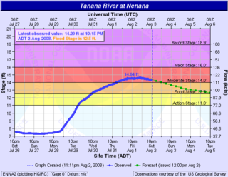
The 2008 Tanana Valley flood or the 2008 Fairbanks flood was a flood in late July and early August 2008 that affected several rivers in the central portion of the American state of Alaska. The city of Fairbanks, Alaska saw high water levels, while the towns of Nenana, Salcha, and Old Minto received heavy damage. The Salcha River and Tanana River reached their second-highest levels since record-keeping began, while the Chena River, which bisects Fairbanks, was kept below flood stage by the use of the Chena River Lakes Flood Control Project.

<span class="mw-page-title-main">Felix Pedro</span>

Felice Pedroni, commonly known by his Hispanicized alias Felix Pedro, was an Italian immigrant whose discovery of gold in Interior Alaska marked the beginning of the 1902 Fairbanks Gold Rush.

<span class="mw-page-title-main">Fairbanks Gold Rush</span> Gold rush near Fairbanks, Alaska in the early 1900s

The Fairbanks Gold Rush was a gold rush that took place in Fairbanks, Alaska in the early 1900s. Fairbanks was a city largely built on gold rush fervor at the turn of the 20th century. Discovery and exploration continue to thrive in and around modern-day Fairbanks.

<span class="mw-page-title-main">E. T. Barnette</span> First mayor of Fairbanks, Alaska

Elbridge Truman Barnette was a Yukon riverboat captain, banker, and swindler, who founded the city of Fairbanks, Alaska, and later served as its first mayor.

<span class="mw-page-title-main">History of Fairbanks, Alaska</span>

The history of Fairbanks, the second-largest city in Alaska, can be traced to the founding of a trading post by E.T. Barnette on the south bank of the Chena River on August 26, 1901. The area had seen human occupation since at least the last ice age, but a permanent settlement was not established at the site of Fairbanks until the start of the 20th century.

<span class="mw-page-title-main">Chena Ridge, Alaska</span> CDP in Alaska, United States

Chena Ridge is a census-designated place (CDP) in Fairbanks North Star Borough, Alaska, United States. It is the location of the former city (1903-73) of Chena, now a ghost town that once rivaled nearby Fairbanks in importance.

<span class="mw-page-title-main">Falcon Joslin House</span> Historic house in Alaska, United States

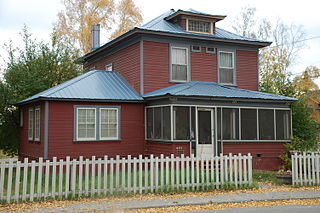
The Falcon Joslin House is a historic house at 413 Cowles Street in Fairbanks, Alaska. Built in 1904, this American Foursquare two-story frame house is the oldest house in Fairbanks set at its original location, and was one of the first frame houses built in what was then a mining camp. The house was built by Falcon Joslin, a Tennessee lawyer who came to Fairbanks and financed construction of the railroad connection to Chena, the head of navigation on the Tanana River. Joslin's railroad ensured the economic success of Fairbanks, which was then competing with Chena as a supply center for miners in the region. In 1930 the house was purchased by Fairbanks Exploration Company, which used it as housing for executives and employees until 1960.

References

  1. "Chena". Geographic Names Information System . United States Geological Survey, United States Department of the Interior . Retrieved October 28, 2019.
  2. "City Governments in Alaska that been dissolved or otherwise ceased to exist" (PDF). State of Alaska Department of Commerce, Community, and Economic Development. April 29, 2015.
  3. Farm Journal Complete World Atlas, 1912 Edition, p. 195
  4. 1 2 3 4 5 News-Miner, Suzanna Caldwell / scaldwell@newsminer.com Fairbanks Daily. "Where's Chena? Surveyor tracks down location of vanished Alaska gold rush town". Fairbanks Daily News-Miner. Retrieved May 23, 2018.
  5. 1 2 3 4 Gutoski, Martin (2013). "Where is Chena?" (PDF). The American Surveyor. 10.
  6. "Race to Grow". History of Chena, AK. August 23, 2011. Retrieved May 23, 2018.
  7. "U.S. Decennial Census". Census.gov. Retrieved June 6, 2013.
  8. "Supplement for Alaska - Population, Agriculture, Manufactures, Mines, and Quarries" (PDF). United States Census Bureau. 1910.
  9. "Population of Outlying Possessions by Civil Divisions: 1920 and earlier years" (PDF). United States Census Bureau. 1920. pp. 680 & 681.
  10. U.S. Census Bureau (June 2012). "2010 Census of Population and Housing - Alaska" (PDF). U.S. Government Printing Office. Archived from the original (PDF) on February 24, 2014.