
College is a census-designated place (CDP) in Fairbanks North Star Borough, Alaska, United States. It is part of the Fairbanks, Alaska Metropolitan Statistical Area. As of the 2020 census, the population was 11,332, down from 12,964 in 2010. College is the third-most populated CDP in Alaska.

Fox is a census-designated place (CDP) in Fairbanks North Star Borough, Alaska, United States. It is part of the Fairbanks, Alaska Metropolitan Statistical Area. At the 2010 census the population was 417, up from 300 in 2000.

Moose Creek is a census-designated place (CDP) in Fairbanks North Star Borough in the U.S. state of Alaska. As of the 2010 census, the population of the CDP was 747, up from 542 in 2000. It is part of the 'Fairbanks, Alaska Metropolitan Statistical Area'. Moose Creek is located south of Fairbanks, Alaska along the Richardson Highway. Moose Creek is bordered by Eielson Air Force Base to the south, the Tanana River to the west, and the Chena River Flood Control Project to the north.
Pleasant Valley is a census-designated place (CDP) in Fairbanks North Star Borough, Alaska, United States. It is part of the Fairbanks, Alaska Metropolitan Statistical Area. The population was 725 at the 2010 census, up from 623 at the 2000 census.

Salcha is a census-designated place (CDP) in Fairbanks North Star Borough in the U.S. state of Alaska. It is part of the Fairbanks, Alaska Metropolitan Statistical Area. The population was 1,095 at the 2010 census, up from 854 in 2000.

Two Rivers is a census-designated place (CDP) in Fairbanks North Star Borough, Alaska, United States. It lies between mile 13 and mile 25 on the Chena Hot Springs Road, northeast of Fairbanks. As of the 2010 United States Census, the CDP had a population of 719, up from 482 in 2000.

Big Delta is a census-designated place (CDP) in Southeast Fairbanks Census Area, Alaska, United States. The population was 591 at the 2010 census, down from 749 in 2000. Big Delta is at the confluence of the Delta River and the Tanana River and gets its name from the huge river delta formed by the confluence.
Deltana is a census-designated place (CDP) in Southeast Fairbanks Census Area, Alaska, United States. At the 2020 census the population was 2,359, up from 2,251 in 2010. Native inhabitants are Tanana Athabaskans.

Healy Lake is a census-designated place (CDP) in Southeast Fairbanks Census Area, Alaska, United States. The population was 13 at the 2010 census, down from 37 in 2000.

Northway is a census-designated place (CDP) in Southeast Fairbanks Census Area, Alaska, United States. Prior to the 2020 Census, the borders of the CDP got expanded to include Northway Junction and Northway Village. The population was 234 at the 2020 census, up from 71 in 2010.
Northway Village was a census-designated place (CDP) in Southeast Fairbanks Census Area, Alaska, United States. It was merged with Northway CDP prior to the 2020 Census. The population was 98 at the 2010 census, down from 107 in 2000.
Tanacross is a census-designated place (CDP) in Southeast Fairbanks Census Area, Alaska, United States. At the 2010 census the population was 136, down from 140 in 2000. It hosts an air tanker base.
Tetlin is a census-designated place (CDP) in Southeast Fairbanks Census Area, Alaska, United States. At the 2010 census the population was 127, up from 117 in 2000.
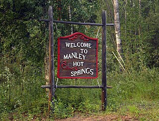
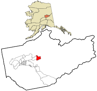
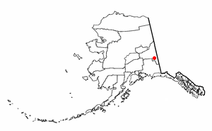
Manley Hot Springs is a census-designated place (CDP) in Yukon-Koyukuk Census Area, Alaska, United States. At the 2020 census the population was 169, up from 89 in 2010.
Minto is a census-designated place (CDP) in Yukon-Koyukuk Census Area, Alaska, United States. As of the 2020 census, the population of the CDP is 150, down from 210 in 2010. The name is an anglicized version of the Lower Tanana Athabaskan name Menhti, meaning 'among the lakes'. After repeated flooding the village was relocated to its present location in 1969. The former village site is now known as Old Minto.

Chena was a former city in interior Alaska, located in the Fairbanks North Star Borough, Alaska, United States, near the confluence of the Chena and Tanana rivers. It incorporated in 1903 and was disincorporated in 1973. The area is now part of the outskirts of Fairbanks, within the CDP of Chena Ridge. Its heyday was in the first two decades of the 20th century, with a peak population of about 400 in 1907. By 1910 the population had fallen to 138.

Farmers Loop is a census-designated place in Fairbanks North Star Borough, Alaska, United States. One of several CDPs created out of various Fairbanks suburbs and outskirts during the 2010 census, at which time it had a population of 4,853. The CDP is located north of Fairbanks and is centered on and named for Farmers Loop Road, a road that runs along the foothills north of Fairbanks between the Steese Highway and the northeastern corner of the University of Alaska Fairbanks campus.

Badger is a census-designated place (CDP) in the Fairbanks North Star Borough of Alaska. It was one of the CDPs created in 2010 out of small suburbs and outskirts of Fairbanks. It has an area of 66.71 sq. mi, 65.63 of land and 1.08 of water.

Steele Creek is a census-designated place (CDP) in Fairbanks North Star Borough, Alaska, United States. It is part of the Fairbanks, Alaska Metropolitan Statistical Area. As of the 2020 census, the population was 6,437, down from 6,662 in 2010. It is the eighth-most populated CDP in Alaska.

Goldstream, Alaska is a census-designated place (CDP) in Alaska, United States. It is part of the Fairbanks, Alaska Metropolitan Statistical Area. As of the 2010 census, the population was 3,557.


