
The Seongsu Bridge, sometimes spelled Sŏngsu Bridge, is a cantilever bridge over the Han River, connecting the Seongdong and Gangnam districts of Seoul, South Korea. The bridge began construction under Hyundai Engineering & Construction on April 26, 1995 and was opened to the public on July 3, 1997 by Seoul Mayor Cho Soon. The original Seongsu Bridge was built in 1979, and was demolished and rebuilt following the Seongsu Bridge disaster on October 21, 1994.

Guui Station (Korean: 구의역) is a station on the Seoul Subway Line 2. Because of its proximity to the Gwangjin District Office, it is also known as Gwangjin-gu Office Station.
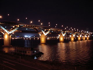
Cheongdam Bridge is a bridge over the Han River in Seoul, South Korea. It is the 18th bridge to be constructed over the river. The bridge links the Gwangjin and Gangnam districts. It carries a section of Line 7 of the Seoul Subway, between Cheongdam Station and Jayang station, on its underside, making it the first "duplex bridge" in South Korea. The road portion is a part of the Dongbu Expressway, which limits the bridge to motor traffic only.

Gangdong District is one of the 25 gu that make up the city of Seoul. Gangdong, literally means "east of river".

The Yanghwa Bridge (Korean: 양화대교), formerly known as the Second Hangang Bridge, is an eight lane bridge spanning the Han River in Seoul, South Korea. The bridge connects Mapo District on the north side of the river to Yeongdeungpo District on the south side of the river. The bridge is buttressed by the eastern end of the island of Seonyudo, home to Seonyudo Park.

Jayang station is a metro station on Seoul Subway Line 7. It is located in Jayang-dong in the Gwangjin District administrative district of Seoul. It is the only station in South Korea to be located on the underside of a bridge, beneath Cheongdam Bridge. The station also runs underneath a highway with two exits being south of the highway and two north. The south exits serve Ttukseom Hangang Park, while the north exits serve Jayang 3-dong and Jayang 4-dong which contain some residential towers with small shops and other mixed commercial and residential areas. The station is serviced by a single bus route which is located at exit 4. Before Line 7 opened the station was known as Jayang Station (자양역).

The Olympic Bridge, also known as the Grand Olympic Bridge, is a bridge over the Han River in Seoul, South Korea. The bridge connects the Gwangjin and Songpa districts.
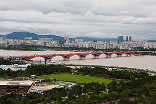
Dongho Bridge is a bridge over the Han River in Seoul, South Korea. It carries road traffic and Seoul Subway Line 3. Oksu station is located at the northern end of this bridge.

Children's Grand Park Station is a rapid transit station on Seoul Subway Line 7. It is located in Mojin-dong, Gwangjin District, Seoul, South Korea. It is also adjacent to Children's Grand Park from which it takes its name.

Cheonho-dong (Korean: 천호동) is a dong (neighborhood) of Gangdong District, Seoul, South Korea.

Gunja-dong is a dong (neighborhood) of Gwangjin District, Seoul, South Korea. It is a transportation hub located on the southern side of Cheonho-daero, to the left of Jungnangcheon.

Yeongdong Bridge is a bridge over the Han River in Seoul, South Korea. The bridge links the Gwangjin and Seongdong districts north of the river to Gangnam district. It was opened on November 8, 1973.
The Hannam Bridge (Korean: 한남대교), formerly known as the Third Hangang Bridge, is a girder bridge over the Han River, South Korea. It connects Sinsa-dong, Gangnam District and Hannam-dong, Yongsan District. The bridge is heavily congested with traffic, with both gu being busy business districts. It was called the Hangang Bridge No. 3 until 1985, when its name was changed to the current name. A trot song "Jesamhanggyo" was popularized by Hye Eun-Yi in 1979. The bridge was originally built to expedite the evacuation of Seoul residents during a potential attack by North Korea.

The Banpo Bridge (Korean: 반포대교) is a major bridge for vehicular traffic over the Han River in central Seoul, South Korea. It is a double-decked bridge, and is above the pedestrian Jamsu Bridge.
The Banghwa Bridge (Korean: 방화대교) is a bridge in South Korea. It crosses the Han River, connecting the Gangseo District, Seoul with Goyang, Gyeonggi Province. The bridge is a part of the Incheon International Airport Expressway. At over 2.5 km in length, it is the longest bridge to cross the Han River. Though mostly a girder bridge, the middle 540m section is an arch truss, resembling the shape of an airplane taking off.
The Seongsan Bridge is a bridge over the Han River in Seoul, South Korea. It connects Mapo District and Yeongdeungpo District. The bridge was completed in June 1980. It has a length of 1,410 m (4,630 ft).

The Jamsil Bridge (Korean: 잠실대교) crosses the Han River in South Korea and connects the districts of Songpa District and Gwangjin District. Completed in 1972, it is the 6th bridge to be constructed over the Han River.

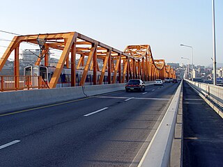
The Gwangjin Bridge (Korean: 광진교) crosses the Han River in South Korea and connects the districts of Gwangjin-gu and Gangdong-gu. The original bridge was completed in 1936, but because of deteriorating conditions, it was rebuilt and reopened in November 2003.

Gubeundari Station is a subway station on Seoul Subway Line 5 in Gangdong District, Seoul.

The Haengju Bridge (Korean: 행주대교) crosses the Han River in South Korea and connects the city of Goyang and the Gangseo District, Seoul. The bridge was first completed in 1978, but the bridge was very narrow and could not handle the increased traffic as the neighboring cities of Ilsan and Bucheon experienced housing booms.


