Cherry River (West Virginia)

Last updated
Cherry River
Cherry River West Virginia.jpg
Cherry River in Nicholas County after heavy rains
Location
Country United States
Physical characteristics
Source 
 - location Pocahontas County, West Virginia (North and South Forks)
 - elevation2,226 ft (678 m) (at confluence of forks at Richwood) [1]
Mouth  
 - location
Gauley River, Nicholas County, West Virginia
The North Fork of the Cherry River in the Monongahela National Forest in northern Greenbrier County North Fork Cherry River West Virginia.jpg
The North Fork of the Cherry River in the Monongahela National Forest in northern Greenbrier County

The Cherry River is a tributary of the Gauley River in southeastern West Virginia in the United States. Via the Gauley, Kanawha and Ohio rivers, it is part of the watershed of the Mississippi River. The Cherry River drains mostly rural and forested areas and flows for much of its length through the Monongahela National Forest. [2] Throughout its entire length the Cherry goes over a series of whitewater rapids in a mountainous setting.

Tributary stream or river that flows into a main stem river or lake

A tributary or affluent is a stream or river that flows into a larger stream or main stem river or a lake. A tributary does not flow directly into a sea or ocean. Tributaries and the main stem river drain the surrounding drainage basin of its surface water and groundwater, leading the water out into an ocean.

Gauley River river in the United States of America

The Gauley River is a 105-mile-long (169 km) river in West Virginia. It merges with the New River to form the Kanawha River, a tributary of the Ohio River. The river features numerous recreational whitewater areas, including those in Gauley River National Recreation Area downstream of the Summersville Dam.

West Virginia State of the United States of America

West Virginia is a state located in the Appalachian region in the Southern United States and is also considered to be a part of the Middle Atlantic States. It is bordered by Pennsylvania to the north, Maryland to the east and northeast, Virginia to the southeast, Kentucky to the southwest, and Ohio to the northwest. West Virginia is the 41st largest state by area, and is ranked 38th in population. The capital and largest city is Charleston.

Contents

History and geography

According to the Geographic Names Information System, the river has also been known historically by the toponyms Cherry Tree Waters and Cherrytree Creek in the past. [3] The present name is for the wild cherry trees along its course. [4]

Geographic Names Information System geographical database

The Geographic Names Information System (GNIS) is a database that contains name and locative information about more than two million physical and cultural features located throughout the United States of America and its territories. It is a type of gazetteer. GNIS was developed by the United States Geological Survey in cooperation with the United States Board on Geographic Names (BGN) to promote the standardization of feature names.

The upper headwaters of the Cherry begin as two separate creeks, the North Fork Cherry River [5] and the South Fork Cherry River, [6] each of which rises in southeastern Pocahontas County and flows generally west-northwestwardly across northern Greenbrier County before converging in Nicholas County at the city of Richwood.

Pocahontas County, West Virginia County in the United States

Pocahontas County is a county located in the U.S. state of West Virginia. As of the 2010 census, the population was 8,719. Its county seat is Marlinton. The county was established in 1821. It is named after the daughter of the Powhatan Native American chief from Jamestown, Virginia. She married an English settler and their mixed-race children became ancestors of many of the First Families of Virginia.

Greenbrier County, West Virginia County in the United States

Greenbrier County is a county in the U.S. state of West Virginia. As of the 2010 census, the population was 35,480. Its county seat is Lewisburg. The county was formed in 1778 from Botetourt and Montgomery counties in Virginia.

Nicholas County, West Virginia County in the United States

Nicholas County is a county located in the U.S. state of West Virginia. As of the 2010 census, the population was 26,233. Its county seat is Summersville. The county was created in 1818 by the Virginia General Assembly and named for Virginia Governor Wilson Cary Nicholas.

Now at an elevation of approximately 2,200 feet above sea level, a unique setting is created by which class 3 whitewater rapids are usually created during spring runoff through a town of about 2,000 residents, viewable from some of the city's public streets. This may be the only place in eastern North America where three categories of "twos" (population, elevation, and whitewater difficulty) are met or eclipsed. (Western US example-the Sacramento River at Dunsmuir, California)

Sacramento River river in Northern and Central California, USA

The Sacramento River is the principal river of Northern California in the United States, and is the largest river in California. Rising in the Klamath Mountains, the river flows south for 400 miles (640 km) before reaching the Sacramento–San Joaquin River Delta and San Francisco Bay. The river drains about 26,500 square miles (69,000 km2) in 19 California counties, mostly within the fertile agricultural region bounded by the Coast Ranges and Sierra Nevada known as the Sacramento Valley, but also extending as far as the volcanic plateaus of Northeastern California. Historically, its watershed has reached as far north as south-central Oregon where the now, primarily, endorheic (closed) Goose Lake rarely experiences southerly outflow into the Pit River, the most northerly tributary of the Sacramento.

Dunsmuir, California City in California

Dunsmuir is a city in Siskiyou County, northern California. It is on the upper Sacramento River in the Trinity Mountains.

Downstream of Richwood, the Cherry River is paralleled by a rail trail, the Cranberry Tri-Rivers Rail-Trail, [7] then flows northwest for about 10 more miles to its confluence with the Gauley in Curtin, a nearly abandoned lumber town two miles south of Craigsville. [2]

Rail trail railroad bed converted to a recreational trail

A rail trail is the conversion of a disused railway track into a multi-use path, typically for walking, cycling and sometimes horse riding and snowmobiling. The characteristics of abandoned railways—flat, long, frequently running through historical areas—are appealing for various developments. The term sometimes also covers trails running alongside working railways; these are called "rails with trails". Some shared trails are segregated, with the segregation achieved with or without separation. Many rail trails are long-distance trails.

Curtin, Nicholas County, West Virginia Unincorporated community in West Virginia, United States

Curtin is a nearly abandoned unincorporated community in eastern Nicholas County, West Virginia, United States. The area is situated at the bottomland surrounding the mouth of the Cherry River at its confluence with the Gauley River. Curtin is also the location where West Virginia Route 55 and West Virginia Route 20 cross the Gauley.

Craigsville, West Virginia CDP in West Virginia, United States

Craigsville is a census-designated place (CDP) in Nicholas County, West Virginia, United States. The population was 2,213 at the 2010 census.

There are currently no dams on the Cherry and the town of Richwood has been subjected to damaging floods, most recently to a "50 year flood" during the current millennium. Local leaders have proposed a dam be placed on the South Fork just above town, thus protecting it from future flooding and potentially creating more reliable flows for whitewater recreation.[ citation needed ]

Richwood, West Virginia City in West Virginia, United States

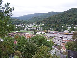
Richwood is a city in Nicholas County, West Virginia, United States. In 2010, the census showed Richwood with a population of 2,051. During the 19th and early 20th century Richwood was a booming coal and lumber town. Richwood has a very rich history, including the formation of the Cherry River Navy civic organization to draw attention to issues important to the community. Richwood has also became known statewide as the "Ramp Capital of the World". Each year, in April, the city hosts a large festival that draws visitors from around the country.

See also

Related Research Articles

Monongahela River river in Pennsylvania and West Virginia, United States

The Monongahela River — often referred to locally as the Mon — is a 130-mile-long (210 km) river on the Allegheny Plateau in north-central West Virginia and southwestern Pennsylvania. The river flows from the confluence of its west and east forks in north central West Virginia northeasterly into southwestern Pennsylvania, then northerly to Pittsburgh and its confluence with the Allegheny River to form the Ohio River. The river is navigable its entire length via a series of locks and dams.

Cheat River river in West Virginia and southwestern Pennsylvania, United States

The Cheat River is a 78.3-mile-long (126.0 km) tributary of the Monongahela River in eastern West Virginia and southwestern Pennsylvania in the United States. Via the Ohio River, the Cheat and Monongahela are part of the Mississippi River watershed. Owing to the ruggedness of the surrounding Allegheny Mountains, the Cheat remains largely remote with few settlements or developments along its banks. Its headwaters are in the Cheat-Potomac Ranger District of the Monongahela National Forest.

The Whitewater River is a 101-mile-long (163 km) southerly flowing right tributary of the Great Miami River in southeastern Indiana and southwestern Ohio in the United States. It is formed by the confluence of two forks, the West Fork and East Fork. The name is a misnomer, as there is no true white water on the river. However, there are many rapids due to the steep gradient present - the river falls an average of six feet per mile (1.1 m/km). The gradient rendered upstream navigation impossible, and in the mid-nineteenth century resulted in the construction of the Whitewater Canal paralleling the river from north of Connersville, Indiana, to the Ohio River.
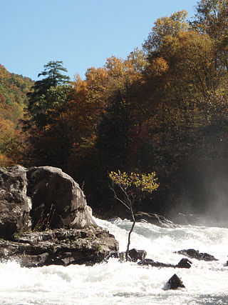
Hughes River (West Virginia) river in the United States of America

The Hughes River is a tributary of the Little Kanawha River in western West Virginia in the United States. Via the Little Kanawha and Ohio Rivers, it is part of the watershed of the Mississippi River. As measured from the confluence of its north and south forks, the Hughes is 18 mi (29 km) long, and drains a rural area of the unglaciated portion of the Allegheny Plateau.

West Fork River river in the United States of America

The West Fork River is a principal tributary of the Monongahela River, 103 miles (166 km) long, in north-central West Virginia in the United States. Via the Monongahela and Ohio Rivers, it is part of the watershed of the Mississippi River, draining an area of 881 square miles (2,284 km²) on the unglaciated portion of the Allegheny Plateau.

Black Fork (Cheat River tributary) river in the United States of America

The Black Fork is a principal tributary of the Cheat River in the Allegheny Mountains of eastern West Virginia, USA. It is a short stream, about four miles (6 km) in length, formed by the confluence of two other streams not far above its mouth. It was traditionally considered one of the five Forks of Cheat.

Blackwater River (West Virginia) river in the United States of America

The Blackwater River is a 34.3-mile-long (55.2 km) river in the Allegheny Mountains of eastern West Virginia, USA. Via the Black Fork, it is a principal tributary of the Cheat River. Via the Cheat, the Monongahela and the Ohio rivers, it is part of the watershed of the Mississippi River and drains an area of 142 square miles (370 km2). It is a true blackwater stream, owing to spruce and hemlock trees in its watershed, the tannins of which impart a tea or amber color to its water.

Shavers Fork river in the United States of America

Shavers Fork of the Cheat River is situated in the Allegheny Mountains of eastern West Virginia, USA. It is 88.5 mi (142.5 km) long and forms the Cheat at its confluence with Black Fork at Parsons. It was traditionally considered one of the five Forks of Cheat and its upper reaches constitute the highest river in the eastern United States.

Dry Fork (Cheat River tributary) tributary of the Black Fork of the Cheat River in West Virginia, USA

The Dry Fork is a 39.1-mile-long (62.9 km) tributary of the Black Fork of the Cheat River in the Allegheny Mountains of eastern West Virginia, USA. Via the Black Fork, the Cheat, and the Monongahela and Ohio rivers, it is part of the watershed of the Mississippi River. The Dry Fork flows for much of its length in the Monongahela National Forest and drains mostly rural and forested areas. It was traditionally considered one of the five Forks of Cheat.

Williams River (West Virginia) river in the United States of America

The Williams River is a tributary of the Gauley River, 33 miles (53 km) long, in east-central West Virginia, USA. Via the Gauley, Kanawha and Ohio Rivers, it is part of the watershed of the Mississippi River, draining an area of 132 square miles (342 km²) in a sparsely populated region of the southern Allegheny Mountains and the unglaciated portion of the Allegheny Plateau.

West Virginia Route 150 is a 22.5-mile (36.2 km) long north–south scenic state highway in the Marlinton and Gauley Ranger Districts of the Monongahela National Forest in southeast West Virginia. The southern terminus of the route is at West Virginia Route 39 and West Virginia Route 55 northwest of Mill Point. The northern terminus is at U.S. Route 219 and WV 55 north of Edray, near Marlinton.

Cranberry River (West Virginia) river in West Virginia, United States

The Cranberry River is a tributary of the Gauley River located in southeastern West Virginia in the United States. It is a part of the Mississippi River watershed, by way of the Gauley, Kanawha, and Ohio Rivers, draining an area of 74 square miles (192 km2).

Summit Lake (West Virginia) lake of the United States of America

Summit Lake is a 43-acre (170,000 m2) cold water reservoir located in Greenbrier County, West Virginia in the Gauley Ranger District of the Monongahela National Forest. The reservoir is formed by the impoundment of the waters of two forks of Coats Run, a small tributary of the North Fork of the Cherry River. There have been attempts to rename the lake in honor of Carl E. Gainer, a politician from nearby Richwood. These efforts, however, have had limited success with local residents and the United States Forest Service.

Glady Fork river in the United States of America

Glady Fork is a 31.9-mile-long (51.3 km) river in the Allegheny Mountains of eastern West Virginia, USA. It is considered one of the five principal headwaters tributaries of the Cheat River — known as the Forks of Cheat.

Laurel Fork (Cheat River tributary) river in the United States of America

Laurel Fork is a 37.8-mile-long (60.8 km) river in eastern West Virginia, USA. It is a tributary of the Dry Fork; via the Dry Fork, the Black Fork, and the Cheat, Monongahela and Ohio rivers, it is part of the watershed of the Mississippi River, draining an area of 60 square miles (160 km2) in the Allegheny Mountains. With the Dry Fork, the Glady Fork, the Shavers Fork and the Blackwater River, it is considered to be one of the five principal headwaters tributaries of the Cheat River.

Middle Fork River river in the United States of America

The Middle Fork River is a 35.4-mile-long (57.0 km) tributary of the Tygart Valley River in north-central West Virginia, USA. Via the Tygart Valley, Monongahela and Ohio rivers, it is part of the watershed of the Mississippi River, draining an area of 152 square miles (390 km2) on the easternmost part of the unglaciated portion of the Allegheny Plateau. According to the Geographic Names Information System, the Middle Fork River has also been known simply as "Middle Fork" and as "Middlefork."

Cranberry Wilderness

The Cranberry Wilderness is a 47,815-acre (19,350 ha) U.S. wilderness area in the Monongahela National Forest of southeast West Virginia, United States. Its name derives from the nearby Cranberry Glades as well as from the Cranberry River and Cranberry Mountain. In addition to being wilderness, it is a designated black bear sanctuary.

Big Run (North Fork South Branch Potomac River tributary)

Big Run is a river of 13 miles in length, located one-and-a-half miles west of Spruce Knob in Monongahela National Forest, in Pendleton County, West Virginia. It is a tributary of the North Fork South Branch Potomac River.

References

  1. Arnold, Amy Donaldson. 2006. "Richwood." The West Virginia Encyclopedia. Ken Sullivan, editor. Charleston, WV: West Virginia Humanities Council. ISBN   0-9778498-0-5.
  2. 1 2 DeLorme (1997). West Virginia Atlas & Gazetteer. Yarmouth, Maine: DeLorme. ISBN   0-89933-246-3.
  3. U.S. Geological Survey Geographic Names Information System: Cherry River
  4. Kenny, Hamill (1945). West Virginia Place Names: Their Origin and Meaning, Including the Nomenclature of the Streams and Mountains. Piedmont, WV: The Place Name Press. p. 169.
  5. U.S. Geological Survey Geographic Names Information System: North Fork Cherry River
  6. U.S. Geological Survey Geographic Names Information System: South Fork Cherry River
  7. West Virginia Rails-to-Trails Council website, reprinted news article about the Cranberry Tri-Rivers Rail-Trail Archived June 14, 2006, at the Wayback Machine .

Coordinates: 38°17′25″N80°38′25″W / 38.2904°N 80.6404°W / 38.2904; -80.6404