
Saskatoon is the largest city in the Canadian province of Saskatchewan. It straddles a bend in the South Saskatchewan River in the central region of the province. It is located along the Trans-Canada Yellowhead Highway, and has served as the cultural and economic hub of central Saskatchewan since its founding in 1882 as a Temperance colony.

The Frederick G. Gardiner Expressway, commonly known as the Gardiner Expressway or simply the Gardiner, is a partially at grade and elevated municipal expressway in Toronto, Ontario, Canada. Running close to the shore of Lake Ontario, it extends from the foot of the Don Valley Parkway (DVP) in the east, just past the mouth of the Don River, to the junction of Highway 427 and the Queen Elizabeth Way (QEW) in the west, for a total length of 18.0 kilometres (11.2 mi). East of Dufferin Street to just east of the Don River, the roadway is elevated for a length of 6.8 kilometres (4.2 mi), unofficially making it the longest bridge in Ontario.
The Don Valley Parkway (DVP) is a municipal expressway in Toronto, Ontario, Canada, which connects the Gardiner Expressway in downtown Toronto with Highway 401. North of Highway 401, it continues as Highway 404. The parkway runs through the parklands of the Don River valley, after which it is named. It has a maximum speed limit of 90 km/h (56 mph) for its entire length of 15.0 km (9.3 mi). It is six lanes for most of its length, with eight lanes north of York Mills Road and four lanes south of Eastern Avenue. As a municipal road, it is patrolled by the Toronto Police Service.

The Kichi Zībī Mīkan, formerly the Sir John A. Macdonald Parkway, and previously the Ottawa River Parkway, is a four-lane scenic parkway along the Ottawa River in Ottawa, Ontario, Canada. It runs from Carling Avenue near Connaught Avenue, to Booth Street at the Canadian War Museum and National Holocaust Monument. It is maintained by the National Capital Commission. The speed limit is 60 km/h (37 mph). Bicycles are allowed on the road and on a parallel recreational path along the parkway.

Highway 15 is a highway in the Edmonton Region of Alberta, connecting northeast Edmonton to the City of Fort Saskatchewan and communities within Lamont County. It serves as an alternative to Highway 16 that bypasses Elk Island National Park. The highway follows the route of a railway line completed in 1905 by the Canadian Northern Railway. In Edmonton, the most southerly portion of the route is named Fort Road, followed by Manning Drive to the north, a developing freeway.

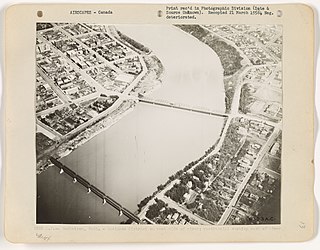
The Traffic Bridge is the name given to two truss bridges constructed across the South Saskatchewan River, connecting Victoria Avenue to 3rd Avenue South and Spadina Crescent in Saskatoon, Saskatchewan, Canada. The original bridge opened on October 10, 1907, and was the first bridge to carry motor vehicle traffic in Saskatoon, replacing an unreliable ferry service. The promised construction of the bridge was considered a prime factor in the amalgamation of the towns of Saskatoon, Nutana and Riversdale into one city named Saskatoon. The Traffic Bridge was the only road bridge in Saskatoon until 1916, when the University Bridge was completed. In 2010, the bridge was permanently closed due to severe corrosion and was demolished by 2016.
Circle Drive Bridge spans the South Saskatchewan River in Saskatoon, Saskatchewan, Canada. It is a steel girder bridge, built in 1983 as part of the Circle Drive freeway system in northeast Saskatoon. At the time of construction, it cost $11.8 million to build. Between its opening in 1983 and the opening of the Chief Mistawasis Bridge in 2018, it was the northernmost vehicular river crossing in the city.
Ring Road is a 4 lane controlled access highway in Regina, Saskatchewan, Canada. Ring Road is a partial ring road or beltway that forms a partial circle around Regina, bypasses the city on the north, east, and south sides, with Lewvan Drive and Pasqua Street N functioning as the de facto western leg. East of Pasqua Street, Ring Road continues west as 9th Avenue N, an arterial road. Ring Road has a speed limit of 100 km/h (60 mph) and consists of 13 interchanges.

University Heights Suburban Development Area (SDA) is an area in Saskatoon, Saskatchewan (Canada). It is a part of the east side community of Saskatoon. It lies (generally) south of the outskirts of the City and the Rural Municipality of Corman Park No. 344, east of the South Saskatchewan River, and Lawson SDA, north of the Lakewood SDA, and Nutana SDA.
The history of Saskatoon began with the first permanent non-indigenous settlement of Saskatoon, Saskatchewan, Canada, in 1883 when Toronto Methodists, wanting to escape the liquor trade in that city, decided to set up a "dry" community in the rapidly growing prairie region. As of 1882 this area was a part of the provisional district named Saskatchewan, North-West Territories (NWT). Their organization, the Temperance Colonization Society, first examined this area in 1882 and found that it would make an excellent location to found their community based on the ideals of the temperance movement; Saskatoon traditionally considers 1882 its founding year and thus marked its centennial in 1982. The settlers, led by John Neilson Lake, arrived on the site of what is now Saskatoon by traveling by railway from Ontario to Moose Jaw, Assiniboia, NWT, and then completing the final leg via horse-drawn cart. The plan for the Temperance Colony soon failed as the group was unable to obtain a large block of land within the community. Nonetheless, John Lake is commonly identified as the founder of Saskatoon; a public school, a park and two streets are named after him.

Willowgrove is a primarily residential neighbourhood located in the east side of Saskatoon, Saskatchewan, Canada. It comprises a mix of mainly single-family detached houses and fewer multiple-unit dwellings. As of 2011, the area is home to 3,973 residents. The neighbourhood is considered a middle to high-income area, with an average family income of $96,002, an average dwelling value of $218,357 and a home ownership rate of 84.8%.

Circle Drive is a major road constructed as a ring road in Saskatoon, Saskatchewan, Canada. Its route constitutes both part of the Yellowhead Highway and Highway 11, signed as both along the entire length. It was first conceived in 1913 by the city commissioner and completed exactly 100 years later in 2013. Most of the route is a fully-controlled access freeway, however the segment between Airport Drive and Millar Avenue has at-grade intersections.
Marquis Industrial is an industrial park located in the North Industrial SDA Suburban Development Area of Saskatoon, Saskatchewan. Industrial parks are usually located close to transport facilities, especially where more than one transport modalities coincide. Sk Hwy 11, and Sk Hwy 12 are all accessed directly from Marquis Industrial. The Saskatoon John G. Diefenbaker International Airport is west of the Sk Hwy 11 Sk Hwy 12 concurrency along Idylwyld Drive.
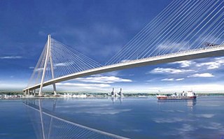
The Gordie Howe International Bridge, known during development as the Detroit River International Crossing and the New International Trade Crossing, is a cable-stayed international bridge across the Detroit River, currently under construction. The crossing will connect Detroit, Michigan, United States of America, and Windsor, Ontario, Canada, by linking Interstate 75 in Michigan with Highway 401 in Ontario. The bridge will provide uninterrupted freeway traffic flow, as opposed to the current configuration with the nearby Ambassador Bridge that connects to city streets on the Ontario side. The bridge is named after Canadian ice hockey player Gordie Howe, whose celebrated career included 25 years with the Detroit Red Wings, and who died two years before construction began.

Evergreen is a residential neighbourhood under construction within the University Heights Suburban Development Area of Saskatoon, Saskatchewan. The residential area is constructed around the village centre and a larger district village. The subdivision was created in 2010. Evergreen is projected to have a density of 8.6 units per acre, becoming one of the densest neighbourhoods in Saskatoon when complete.

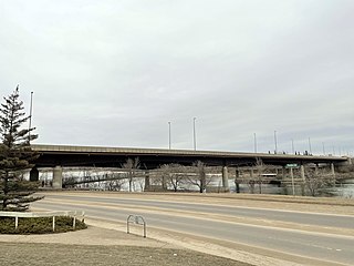
The Gordie Howe Bridge is a vehicular freeway bridge that spans the South Saskatchewan River in Saskatoon, Saskatchewan, Canada. It is a steel girder bridge, built as part of the Circle Drive freeway system in southwestern Saskatoon. At the time of construction, it was projected to cost $272.5 million to build. It is the southernmost road bridge in the city. The bridge is located adjacent to the Grand Trunk Bridge. It is also the longest of Saskatoon's bridges at 440 metres (1,440 ft) in length, and the first to have a concrete road surface. The bridge was scheduled to open with the completion of the entire Circle Drive South project on September 30, 2012. However, record rainfall, high water tables and an early snowfall made that deadline unfeasible. The actual completion and opening date was July 31, 2013.

Aspen Ridge is a neighbourhood located in northeast Saskatoon, Saskatchewan, Canada, construction on which began in 2014. At full build-out, Aspen Ridge will eventually house an estimated 13,000 people. Unlike many of the city's suburban neighbourhoods, it will feature higher density housing on a grid network of roads.
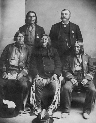
Mistawasis was a Chief of the Sak-kaw-wen-o-wak Plains Cree, notable for his role as the leader of his people during the signing of Treaty 6 in 1876, to which he was the first signatory. Due to the dwindling buffalo population caused by excessive hunting, he was forced to look for new strategies to ensure the survival of his people and their culture. He believed the only way to save his people was to negotiate with the Canadian Government. As a result of his strong influence over the Cree people, he and his close ally Ahtahkakoop were able to argue successfully for the adoption of Treaty 6 by his fellow Cree. After the treaty was signed he remained an ally of the Canadian government until his death.
Calgary Trail and Gateway Boulevard are a pair of major arterial roadways in Edmonton, Alberta. Gateway Boulevard carries northbound traffic while Calgary Trail carries southbound traffic. From south of 31 Avenue, they form a two-way freeway separated by a median; for this portion, the roadway maintains the separate names for northbound and southbound traffic. Near 31 Avenue, Calgary Trail and Gateway Boulevard separate and become parallel one-way arterial roadways to Saskatchewan Drive, at the edge of the North Saskatchewan River valley. Designated as part of Highway 2 south of Whitemud Drive, it is Edmonton's main southern entrance and is both a major commuter route, connecting to the Edmonton International Airport and Leduc, as well as a regional connection to Red Deer and Calgary.
The Saskatoon Freeway is a proposed four-lane limited access highway in and adjacent to Saskatoon, Saskatchewan. The 55-kilometre (34 mi) route will connect Highway 11 (south) with Highway 7, forming a partial ring road around the city of Saskatoon. When complete, it will serve as a replacement bypass route for the existing Circle Drive.

